Menu

Ireland's sailing, boating & maritime magazine

Inland afloat headers


Displaying items by tag: marine science

#MarineScience - The public consultation on a new plan setting out Ireland's Marine Research and Innovation Strategy for the period 2016-2021 has been extended till Friday 30 December.

As previously reported on Afloat.ie, the draft strategy as prepared by the Marine Institute provides a unified view of marine-related funding requirements across a range of societal challenges such as transport, food, energy and biodiversity.

And it aims to build on the significant progress made during the implementation of Ireland's previous marine research, knowledge and innovation strategy, Sea Change 2007-2013.

Details on the consultation’s online survey can be found HERE.

Published in Marine Science

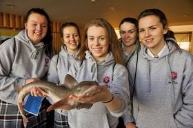
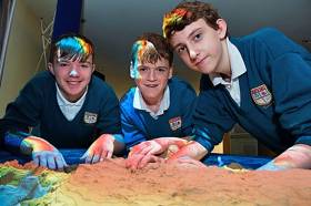
#MarineScience - The Marine Institute welcomed over 250 visitors to its headquarters in Oranmore for the maritime innovation agency’s annual open day on Wednesday (23 November).

Organised as part of the Galway Science & Technology Festival and designed mainly for Transition Year students, this year the Marine Institute decided to open its doors to all, and attracted Leaving Cert students, teachers and parents, plus university and community groups from across the country.

Visitors had the opportunity to tour the state-of-the-art facilities in Oranmore and to meet with researchers and scientists and hear about their careers in the marine sector, which already supports over 30,000 direct and indirect jobs.

The institute also organised a series of interactive exhibitions to introduce visitors to some of the innovative work happening in areas including seabed mapping, research vessel operations and oceanography, as well as fisheries and the marine environment.

Find out more about the Marine Institute and its work at the Galway and Science & Technology Festival Exhibition this Sunday 27 November at NUI Galway from 10am till 6pm.

Published in Marine Science

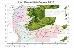
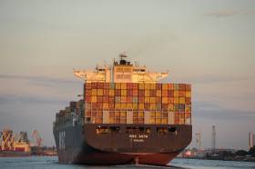
#MarineNotice - The Marine Institute advises that the annual Irish Groundfish Survey (IGFS2016) will be carried out off the South and West coasts of Ireland between Monday 14 November and Sunday 18 December in fulfilment of Ireland’s Common Fisheries Policy obligations.

The IGFS is a demersal trawl survey consisting of a minimum of 125 fishing hauls of 30 minutes duration each. Fishing in 2016 will take place within a 2nm radius of the positions indicated in Marine Notice 44 of 2016, available to read or download HERE.

The survey will be conducted by the RV Celtic Explorer (Callsign EIGB), which will display all appropriate lights and signals during the survey and will also be listening on VHF Channel 16. The vessel will be towing a high headline GOV 36/47 demersal trawl during fishing operations.

The Marine Institute requests that commercial fishing and other marine operators keep a 2nm area around the tow points clear of any gear or apparatus during the survey period.

While there is no statutory provision for the loss of gear at sea, the Marine Institute will make every effort to avoid gear adequately marked according to legislation that may be encountered in the notified areas.

In the event that an operator has static gear or other obstructions within 2nm of the points listed above it is the responsibility of the owner to notify the survey managers or vessel directly. This should be communicated by identifying specifically which ‘Prime Station’ is of concern using the appendix and contact details provided in the Marine Notice. It is not required to provide positional details of commercial operations beyond 3-4nm of the survey points provided.

Specifics of any fishing gear or other obstructions that are known and cannot be kept clear of these survey haul locations can be notified using the contact details provided in the Marine Notice.

Published in Fishing

#MarineScience - A new plan setting out Ireland's Marine Research and Innovation Strategy for the period 2016-2021 is now available for public consultation until Tuesday 22 November.

The draft strategy, prepared by the Marine Institute, provides a unified view of marine-related funding requirements across a range of societal challenges such as transport, food, energy and biodiversity.

It aims to build on the significant progress made during the implementation of Ireland's previous marine research, knowledge and innovation strategy, Sea Change 2007-2013.

The strategy has been developed following detailed review of marine research performance in Ireland, as well a review of the major policy and sectoral drivers.

A key aim of the strategy is to provide a guide for Government and funding agencies to where there are gaps in marine research to meet the needs of society as stated in national strategies such as Innovation 2020, the national research and innovation strategy.

"Significant progress has been made in marine research and it has become clear that marine research in Ireland has moved from being what was considered by some as a niche field, to a theme that is integral to the development of many sectors such as energy, transport, food, and biodiversity,” said Marine Institute chief executive Dr Peter Heffernan.

The strategy aims to raise the research capacity across a number of identified themes and to ensure that funding is targeted to match requirements highlighted in state policies and sectoral plans.

"There is a high degree of co-ordination in the State's approach to research funding, as we have seen through the national research prioritisation exercise and more recently the publication of Innovation 2020,” added Dr Heffernan.

“We hope the Marine Research and Innovation Strategy will contribute to that coordinated approach by providing important insights to funding agencies as to how best to target their resources in the cross cutting area of marine research."

All citizens and organisations are welcome to contribute to this consultation.

“We've chosen to make the document available to as wide an audience as possible through public consultation in the spirit of engaging with the sea, a key goal of Harnessing Our Ocean Wealth, Ireland's integrated marine plan,” said Dr Heffernan. “We hope that as many people as possible will contribute to the consultation process.”

The purpose of the public consultation is to collect views and opinions on the strategy, its scope, objectives, and expected impacts.

View the draft Marine Research and Innovation Strategy and give your feedback no later than 5pm on Tuesday 22 November. Feedback from the consultation will be analysed and considered by the Marine Institute before the strategy is finalised.

Ten questions have been designed to capture your views on the strategy. Complete the online survey HERE or email your responses to [email protected].

Consultation questions and background briefing documents are also available.

Published in Marine Science

#GlobalSulphur - The International Maritime Organistions IMO’s Marine Environment Protection Committee (MEPC) has reached an agreement on global sulphur cap.

The IMO last week agreed in favour of maintaining the deadline of 2020 for introducing a global cap of 0.5% sulphur content in marine fuels.

Responding to the breakthrough, the European Sea Ports Organisation (ESPO) congratulated the IMO on its decision. By setting 2020 as deadline for this global 0.5% sulphur cap, the IMO timing is being aligned with the EU timing as foreseen in the current Sulphur Directive. This will mean equal rules for EU and its neighbouring countries.

European ports are also convinced of the environmental and public health benefits of this reduction target.

Commenting on th decision, ESPO’s Secretary General Isabelle Ryckbost said “It is clear that limiting the sulphur exhaust emissions can have an enormous impact on the local air quality. This decision thus means a big step forward for the maritime and port industry and the people around the ports. In fact, 90% of European ports are very close to urban areas. Moreover, by maintaining 2020, IMO shows that an ambitious greening agenda is possible at global level. We must hope that IMO will demonstrate the same level of ambition when addressing climate change” 

Published in Ports & Shipping

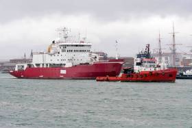
#ShackletonShips - The Ross Sea announced as the World’s largest marine park in the Antarctic is where ice patrol survey ship HMS Endurance nearly sank in the south Atlantic in 2008. Since then the ship has remained laid up, however in recent months she was scrapped, writes Jehan Ashmore.

HMS Endurance (A171) a former Royal Navy vessel based in the polar seas was named in honour of Sir Ernest Shackleton’s original expedition sail and steam ship Endurance.

The three-masted barquentine, Endurance was crushed by pack ice and sunk more than a century ago in late 1915. The incident took place during the Imperial Trans-Antarctic expedition of 1914-1918 led by the Irish born polar explorer. A 15ft model of the ship is on display in the Athy Heritage Museum, Co. Kildare and more recently a statue of Shackleton was unveiled. 

The 1995 built HMS Endurance had a near floundering incident in December 2008 while off Chile. The 5,129 gross tonnage vessel suffered flooding of her engine room that nearly sank her, following an error during routine maintenance on a sea suction strainer.

The damage was so severe that HMS Endurance was transported by semi-submersible ship to the UK, firstly Dartmouth and then Portsmouth  Naval Base. It was deemed far too expensive to carry out repairs and she was sold for scrap in 2013, however since Afloat’s coverage almost three years ago, the towage of the vessel only took place in June when bound for breakers in Turkey.

She had been employed as a hydrographic and support vessel for British Antarctic Survey (BAS), which is responsible for the UK's national scientific activities in Antarctica. A £150m newbuild RRS Sir David Attenborough currently under construction will join her fleetmates as outlined below. 

HMS Endurance was originally built as MV Polar Circle for Norwegians in 1990, then chartered to the Royal Navy and purchased. The navy equipped the vessel with Lynx helicopters as BAS aircraft cannot reach certain locations in the vast polar expanse.

Currently, the Royal Navy’s presence in these polar waters and the South Atlantic is tasked to HMS Protector (A173). Likewise of her predecessor, she operates along with BAS ships.

They are the civilian-manned polar research vessels, RRS Ernest Shackleton and RRS James Clarke Ross. The naming of the ship honours that of the British explorer who in 1841 visited the area (Ross Sea) located in southern Antarctica.

Published in Marine Science

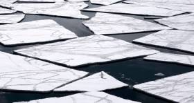
#AntarcticPark - The European Union and 24 countries yesterday agreed to create the world’s largest marine park in the Antarctic Ocean, covering a massive 1.55 million square km (600,000 square miles) of ocean.

The Irish Times writes the Commission for the Conservation of Antarctic Marine Living Resources, meeting in Hobart, Australia, said the Ross Sea marine park would be protected from commercial fishing for 35 years.The Ross Sea is seen as one of the world’s most ecologically important oceans.

The sanctuary will cover more than 12 per cent of the Southern Ocean, which is home to more than 10,000 species including most of the world’s penguins, whales, seabirds, colossal squid and Antarctic tooth fish.

Fishing will be banned completely in 1.1 million square km (425,000 square miles) of the Ross Sea, while areas designated as research zones will allow for some fishing for krill and sawfish.

Scientists and activists described the agreement as a historic milestone in global efforts to protect marine diversity.

For more the newspaper has the report here.

Published in Marine Science

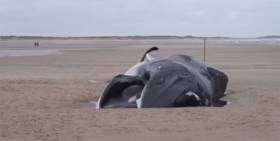
#MarineWildlife - Marine scientists have been puzzled by the recent beaching of a whale rarely seen off the east coast of England.

According to the Guardian, the carcass of a 12m fin whale washed up at Holkham in Norfolk last Thursday afternoon (20 October), far from its usual waters between Britain and Ireland.

“You never get them in the North Sea, so what it was doing there, we have no idea at the moment,” biologist Dr Ben Garrod told the newspaper.

It’s not yet known what causes the marine giant’s death, though collision with a vessel in the North Sea has been mooted as one possibility, as the Eastern Daily Press reports.

Published in Marine Wildlife

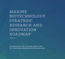
#MarineScience - As previously highlighted on Afloat.ie, the Marine Biotechnology Research and Innovation Roadmap was launched by the EU-funded Marine Biotechnology Consortium (ERA-MBT) last week in Brussels.

The consortium brings together 19 partners from 14 countries across Europe to work with stakeholders in identifying marine biotechnological needs, and gaps in the value chain in an attempt to increase the valorisation of marine bioresources.

Developing a roadmap for future research and innovation was a key project deliverable, and it will now set the direction for future marine biotechnology developments and transnational activities in Europe.

Ireland's Marine Institute is a partner in ERA-MBT and led the development of the Marine Biotechnology Strategic Research and Innovation Roadmap. Chief executive Dr Peter Heffernan congratulated all those involved in the development of the roadmap, in particular Dr Dermot Hurst, who led the Marine Institute's contribution.

"The role played by the Marine Institute in supporting the development of Ireland's marine biotechnology research capabilities through funds awarded to the NutraMara and Beaufort Biodiscovery projects has placed Ireland in a strong international position as a recognised leader in marine biotechnology and related research,” said Dr Heffernan.

Today's bioeconomy is advancing faster and showing greater promise than ever before, driven by both scientific advances and markets demanding sustainable solutions to todays global grand challenges of food and fuel security, sustainable industry and population health.

The global market for marine biotechnology has the potential to reach €5.8 billion by 2025, and Europe is recognised as a high-potential region for future growth resulting from an extensive, yet largely unexplored marine resource.

The Marine Biotechnology Strategic Research and Innovation Roadmap, which is available to download HERE, has been developed to support the development of marine biotechnology research and innovation, enabling its growth within a self-sustained enterprise driven network. The roadmap provides a practical and realistic approach by which marine bioresources and biotechnology can contribute to economic and societal progress.

National and European policy organisations can use the roadmap in developing measures to maximise the contribution of the oceans’ bioresources to the bioeconomy and societal welfare, and funding agencies can use it to identify marine biotechnology related research themes.

Speaking from Ireland's perspective, Dr Heffernan added: "This roadmap directs attention to areas of research which are relevant to Ireland's enterprise sector and as such confirms the opportunities described by the Harnessing Our Ocean Wealth Development Task Force regarding marine resource-based industries adding value to their products and services through marine biotechnology."

Published in Marine Science

#MarineScience - The Marine Institute is set to open its doors for its annual Open Day on Wednesday 23 November from 9.30am to 3pm.

The Open Day at Ireland's national agency for marine research, technology, development and innovation is especially aimed at second level students from Transition Year to the Leaving Cert cycle, their teachers and parents.

Visitors will have the opportunity to tour the state-of-the-art facilities on offer in Oranmore and to meet with researchers and scientists and hear about their careers in the marine.

They will also get to see some of the institute’s innovative work through a series of interactive exhibitions, including seabed mapping, research vessel operations and oceanography, as well as in fisheries and the marine environment.

There are three two-hour sessions available for student groups on the day: 9.30am to 11.30am, 11.15am to 1.15pm and 1pm to 3pm.

Places are limited, and will be allocated on a first come, first served basis. To book, contact Kathleen Sweeney at [email protected] before Friday 28 October.

Last year the Marine Institute hosted some 300 Transition Year students during Science Week as part of the Galway Science & Technology Festival, as previously reported on Afloat.ie.

Published in Marine Science
Page 13 of 35

General Information on using Waterways Ireland inland navigations

Safety on the Water

All users of the navigations are strongly recommended to make themselves aware of safety on the water for whatever activity they are involved in and to read the advice offered by the various governing bodies and by:

The Dept. of Transport, Ireland: www.gov.ie/transport and The Maritime and Coastguard Agency, UK, The RNLI – Water Safety Ireland for information in terms of drowning prevention and water safety.

Registration of Vessels

All vessels using the Shannon Navigation, which includes the Shannon-Erne Waterways and the Erne System must be registered with Waterways Ireland. Only open undecked boats with an engine of 15 horsepower or less on the Shannon Navigation, and vessels of 10 horsepower or less on the Erne System, are exempt. Registration is free of charge.

Craft registration should be completed online at: https://www.waterwaysireland.org/online-services/craft-registration

Permits for use of the Grand and Royal Canals and the Barrow Navigation

All vessels using the Grand and Royal Canals and the Barrow Navigation must display appropriate valid Permit(s) i.e A Combined Mooring and Passage Permit (€126) and if not intending to move every five days, an Extended Mooring Permit (€152).

Permit applications should be completed online at: https://www.waterwaysireland.org/online-services/canal-permits

Passage on the Royal and Grand Canals – Dublin Area

For boat passage through the locks east of Lock 12 into / out of Dublin on either the Royal or Grand Canals, Masters are requested to contact the Waterways Ireland Eastern Regional Office (M-F 9.30am-4.30pm) on tel: +353(0)1 868 0148 or email [email protected] prior to making passage in order to plan the necessary lock-keeping assistance arrangements.

On the Grand Canal a minimum of two days notice prior to the planned passage should be given, masters should note that with the exception of pre-arranged events, a maximum of 2 boats per day will be taken through the locks, travelling either east or west.

Movements in or out of the city will be organised by prior arrangement to take place as a single movement in one day. Boaters will be facilitated to travel the system if their passage is considered to be safe by Waterways Ireland and they have the valid permit(s) for mooring and passage.

Newcomen Lifting Bridge

On the Royal Canal two weeks’ notice of bridge passage (Newcomen Lifting Bridge) is required for the pre-set lift date, and lock assistance will then also be arranged. A minimum of 2 boats is required for a bridge lift to go ahead.

Waterways Ireland Eastern Regional Office (Tel: +353(0)1 868 0148 or [email protected] ) is the point of contact for the bridge lift.

A maximum number of boats passing will be implemented to keep to the times given above for the planned lifts (16 for the Sat / Sun lifts & 8 for the weekday lifts). Priority will be given on a first come first served basis.

On day of lift, boaters and passengers must follow guidance from Waterways Ireland staff about sequence of passage under bridge & through Lock 1, and must remain within signed and designated areas.

Events Held on the Waterways

All organised events taking place on the waterways must have the prior approval of Waterways Ireland. This is a twelve week process and application forms must be accompanied with the appropriate insurance, signed indemnity and risk assessment. The application should be completed on the Waterways Ireland events page at :

https://www.waterwaysireland.org/online-services/event-approval

Time Limits on Mooring in Public Harbours

On the Shannon Navigation and the Shannon-Erne Waterway craft may berth in public harbours for five consecutive days or a total of seven days in any one month.

On the Erne System, revised Bye Laws state that: No master or owner shall permit a vessel, boat or any floating or sunken object to remain moored at or in the vicinity of any public mooring, including mooring at any other public mooring within 3 kilometres of that location, for more than 3 consecutive days and shall not moor at that same mooring or any other public mooring within 3 kilometres of that location within the following 3 consecutive days without prior permission by an authorised official.

Winter Mooring on the Shannon Navigation and Shannon Erne Waterway

Winter mooring may be availed of by owners during the period 1 Nov to 31 Mar by prior arrangement and payment of a charge of €63.50 per craft. Craft not availing of Winter Mooring must continue to comply with the “5 Day Rule”. Winter Mooring applications should be completed online at : https://www.waterwaysireland.org/online-services/winter-moorings-booking

Owners should be aware that electricity supply and water supply to public moorings is disconnected for the winter months. This is to protect against frost damage, to reduce running costs and to minimise maintenance requirements during the winter months.

Vessel owners are advised that advance purchasing of electricity on the power bollards leading up to the disconnection date should be minimal. Electricity credit existing on the bollards will not be recoverable after the winter decommissioning date. Both services will be reinstated prior to the commencement of the next boating season.

Smart Cards

Waterways Ireland smart cards are used to operate locks on the Shannon Erne Waterway, to access the service blocks, to use the pump-outs along the navigations, to avail of electrical power at Waterways Ireland jetties.

Berthing in Public Harbours

Masters are reminded of the following:

  • Equip their vessel with mooring lines of appropriate length and strength and only secure their craft to mooring bollards and cleats provided for this purpose.
  • Ensure the available berth is suitable to the length of your vessel, do not overhang the mooring especially on finger moorings on floating pontoon moorings.
  • Ensure mooring lines, electric cables and fresh water hoses do not create a trip hazard on public jetties for others users.
  • Carry sufficient fenders to prevent damage to your own vessel, other vessels and WI property.
  • Allow sufficient space between your vessel and the vessel ahead /astern (c.1m) for fire safety purposes and /or to recover somebody from the water.
  • Do not berth more than two vessels side by side and ensure there is safe access/egress at all times between vessels and onto the harbour itself.
  • Do not berth in such a way to prevent use of harbour safety ladders, slipways or pump-outs.
  • Do not allow the bow of your vessel to overhang the walkway of a floating mooring thus creating a hazard for others with an overhanging anchor or bow fendering.
  • Animals are not allowed to be loose or stray at any time.
  • Harbour and jetty infrastructure such as railings, power pedestals, fresh water taps, electric light poles, safety bollards, ladders etc are not designed for the purpose of mooring craft , they will not bear the strain of a vessel and will be damaged.
  • At Carrybridge on the Erne System, Masters of vessels are not permitted to use stern on mooring. Masters of vessels must use the mooring fingers for mooring of vessels and for embarkation / disembarkation from vessels.

Passenger Vessel Berths

Masters of vessels should not berth on passenger vessel berths where it is indicated that an arrival is imminent. Passenger vessels plying the navigations generally only occupy the berths to embark and disembark passengers and rarely remain on the berths for extended periods or overnight.

Lock Lead-in Jetties

Lead-in jetties adjacent to the upstream and downstream gates at lock chambers are solely for the purpose of craft waiting to use the lock and should not be used for long term berthing.

Vessel Wake

Vessel wake, that is, the wave generated by the passage of the boat through the water, can sometimes be large, powerful and destructive depending on the hull shape and engine power of the vessel. This wake can be detrimental to other users of the navigation when it strikes their craft or inundates the shoreline or riverbank. Masters are requested to frequently look behind and check the effect of their wake / wash particularly when passing moored vessels, on entering harbours and approaching jetties and to be aware of people pursuing other activities such as fishing on the riverbank.

Speed Restriction

A vessel or boat shall not be navigated on the Shannon Navigation at a speed in excess of 5 kph when within 200 metres of a bridge, quay, jetty or wharf, when in a harbour or canal or when passing within 100 metres of a moored vessel or boat.

Vessels navigating the Shannon-Erne Waterway should observe the general 5 kph speed limit which applies along the waterway. This is necessary in order to prevent damage to the banks caused by excessive wash from vessels.

Vessels navigating the Erne System should observe the statutory 5kt / 6mph / 10kph speed limit areas.

A craft on the Royal and Grand canals shall not be navigated at a speed in excess of 6km per hour.

A craft on the Barrow Navigation shall not be navigated at a speed in excess of 11km per hour except as necessary for safe navigation in conditions of fast flow.

Bank Erosion

Narrow sections of all the navigations are particularly prone to bank erosion due to the large wash generated by some craft. Masters are requested to be vigilant and to slow down to a speed sufficient to maintain steerage when they observe the wash of their craft inundating the river banks.

Unusual Waterborne Activity

Unusual waterborne vessels may be encountered from time to time, such as, hovercraft or amphibious aircraft / seaplanes. Masters of such craft are reminded to apply the normal “Rule of the Road” when they meet conventional craft on the water and to allow extra room to manoeuvre in the interest of safety.

Sailing Activity

Mariners will encounter large numbers of sailing dinghies from late June to August in the vicinity of Lough Derg, Lough Ree and Lower Lough Erne. Sailing courses are marked by yellow buoys to suit weather conditions on the day. Vessels should proceed at slow speed and with due caution and observe the rules of navigation when passing these fleets, as many of the participants are junior sailors under training.

Rowing

Mariners should expect to meet canoes and vessels under oars on any part of the navigations, but more so in the vicinity of Athlone, Carrick-on-Shannon, Coleraine, Enniskillen and Limerick. Masters are reminded to proceed at slow speed and especially to reduce their wash to a minimum when passing these craft as they can be easily upset and swamped due to their very low freeboard and always be prepared to give way in any given traffic situation.

Canoeing

Canoeing is an adventure sport and participants are strongly recommended to seek the advice of the sport’s governing bodies i.e Canoeing Ireland and the Canoe Association of Northern Ireland, before venturing onto the navigations.

Persons in charge of canoes are reminded of the inherent danger to these craft associated with operating close to weirs, sluice gates, locks and other infrastructure particularly when rivers are in flood and large volumes of water are moving through the navigations due to general flood conditions or very heavy localised precipitation e.g. turbulent and broken water, stopper waves. Shooting weirs is prohibited without prior permission of Waterways Ireland.

Canoeists should check with lockkeepers prior entering a lock to ensure passage is done in a safe manner. Portage is required at all unmanned locks.

Canoe Trail Network – "Blueways"

Masters of powered craft are reminded that a canoe trail network is being developed across all navigations and to expect more organised canoeing along these trails necessitating slow speed and minimum wash when encountering canoeists, rowing boats etc

Rockingham and Drummans Island Canals – Lough Key

It is expected that work on Rockingham and Drummans Island Canals on Lough Key will be completed in 2021. Access to these canals will be for non-powered craft only, eg canoes, kayaks, rowing boats.

Fast Powerboats and Personal Watercraft (Jet Skis)

Masters of Fast Powerboats (speed greater than 17kts) and Personal Watercraft (i.e.Jet Skis) are reminded of the inherent dangers associated with high speed on the water and especially in the confines of small bays and narrow sections of the navigations. Keeping a proper look-out, making early alterations to course and /or reducing speed will avoid conflict with slower vessels using the navigation. Personal Watercraft are not permitted to be used on the canals.

Towing Waterskiers, Wakeboarders, Doughnuts etc

Masters of vessels engaged in any of these activities are reminded of the manoeuvring constraints imposed upon their vessel by the tow and of the added responsibilities that they have to the person(s) being towed. These activities should be conducted in areas which are clear of conflicting traffic. It is highly recommended that a person additional to the master be carried to act as a “look-out” to keep the tow under observation at all times.

Prohibition on Swimming

Swimming in the navigable channel, particularly at bridges, is dangerous and is prohibited due to the risk of being run over by a vessel underway in the navigation.

Age Restrictions on operating of powered craft

In the Republic of Ireland, Statutory Instrument 921 of 2005 provides the legal requirements regarding the minimum age for operating of powered craft. The Statutory Instrument contains the following requirements:

- The master or owner of a personal watercraft or a fast power craft shall take all reasonable steps to ensure that a person who has not attained the age of 16 years does not operate or control the craft

- The master or owner of a pleasure craft powered by an engine with a rating of more than 5 horse power or 3.7 kilowatts shall take all reasonable steps to ensure that a person who has not attained the age of 12 years does not operate or control the craft.

Lifejackets and Personal Flotation Devices (PFDs)

Lifejackets and PFD’s are the single most important items of personal protective equipment to be used on a vessel and should be worn especially when the vessel is being manoeuvred such as entering / departing a lock, anchoring, coming alongside or departing a jetty or quayside.

In the Republic of Ireland, Statutory Instrument 921 of 2005 provides the legal requirements regarding the wearing of Personal Flotation Devices. The Statutory Instrument contains the following requirements:

- The master or owner of a pleasure craft (other than a personal watercraft) shall ensure, that there are, at all times on board the craft, sufficient suitable personal flotation devices for each person on board.

- A person on a pleasure craft (other than a personal watercraft) of less than 7 metres length overall shall wear a suitable personal flotation device while on board an open craft or while on the deck of decked craft, other than when the craft is made fast to the shore or at anchor.

- The master or owner of a pleasure craft (other than a personal watercraft) shall take all reasonable steps to ensure that a person who has not attained the age of 16 years complies with paragraph above.

- The master or owner of a pleasure craft (other than a personal watercraft), shall take all reasonable steps to ensure that a person who has not attained the age of 16 years wears a suitable personal flotation device while on board an open craft or while on the deck of a decked craft other than when it is made fast to the shore or at anchor.

- The master or owner of a pleasure craft (other than a personal watercraft) shall take all reasonable steps to ensure that a person wears a suitable personal flotation device, at all times while – (a) being towed by the craft, (b) on board a vessel or object of any kind which is being towed by the craft.

Further information is available at: http://www.irishstatutebook.ie/eli/2005/si/921/made/en/print

Firing Range Danger Area – Lough Ree

The attention of mariners is drawn to the Irish Defence Forces Firing Range situated in the vicinity of buoys No’s 2 and 3, on Lough Ree on the Shannon Navigation. This range is used regularly for live firing exercises, throughout the year, all boats and vessels should stay clear of the area marked with yellow buoys showing a yellow "X" topmark and displaying the word "Danger".

Shannon Navigation, Portumna Swing Bridge Tolls

No attempt should be made by Masters’ of vessels to pay the bridge toll while making way through the bridge opening. Payment will only be taken by the Collector from Masters when they are secured alongside the jetties north and south of the bridge.

Navigating from Killaloe to Limerick on the Shannon Navigation

The navigation from Killaloe to Limerick involves passage through Ardnacrusha locks, the associated headrace and tailrace and the Abbey River into Limerick City. Careful passage planning is required to undertake this voyage. Considerations include: lock passage at Ardnacrusha, water flow in the navigation, airdraft under bridges on Abbey River in Limerick, state of tide in Limerick

Users are advised to contact the ESB Ardnacrusha hydroelectric power station (00353 (0)87 9970131) 48 hours in advance of commencing their journey to book passage through the locks at Ardnacrusha. It is NOT advised to undertake a voyage if more than one turbine is operating (20MW), due to the increased velocity of flow in the navigation channel, which can be dangerous. To ascertain automatically in real time how many turbines are running, users can phone +353 (0)87 6477229.

For safety reasons the ESB has advised that only powered craft with a capacity in excess of 5 knots are allowed to enter Ardnacrusha Headrace and Tailrace Canals.

Passage through Sarsfield Lock should be booked on +353-87-7972998, on the day prior to travel and it should be noted also that transit is not possible two hours either side of low water.

A Hydrographic survey in 2020 of the navigation channel revealed that the approach from Shannon Bridge to Sarsfield Lock and the Dock area has silted up. Masters of vessels and water users are advised to navigate to the Lock from Shannon bridge on a rising tide one or two hours before High Tide.

Lower Bann Navigation

The attention of all users is drawn to the “Users Code for the Lower Bann”, in particular to that section covering “Flow in the River” outlining the dangers for users both on the banks and in the navigation, associated with high flow rates when the river is in spate. Canoeists should consult and carry a copy of the “Lower Bann Canoe Trail” guide issued by the Canoe Association of Northern Ireland. Users should also contact the DfI Rivers Coleraine, who is responsible for regulating the flow rates on the river, for advisory information on the flow rates to be expected on any given day.

DfI Rivers Coleraine. Tel: 0044 28 7034 2357 Email: [email protected]

Lower Bann Navigation – Newferry – No wake zone

A No Wake Zone exists on the Lower Bann Navigation at Newferry. Masters of vessels are requested to proceed at a slow speed and create no wake while passing the jetties and slipways at Newferry.

Overhead Power Lines (OHPL) and Air draft

All Masters must be aware of the dangers associated with overhead power lines, in particular sailing vessels and workboats with cranes or large air drafts. Voyage planning is a necessity in order to identify the location of overhead lines crossing the navigation.

Overhead power line heights on the River Shannon are maintained at 12.6metres (40 feet) from Normal Summer level for that section of navigation, masters of vessels with a large air draft should proceed with caution and make additional allowances when water levels are high.

If a vessel or its equipment comes into contact with an OHPL the operator should NOT attempt to move the vessel or equipment. The conductor may still be alive or re-energise automatically. Maintain a safe distance and prevent third parties from approaching due to risk of arcing. Contact the emergency services for assistance.

Anglers are also reminded that a minimum ground distance of 30 metres should be maintained from overhead power lines when using a rod and line.

Submarine Cables and Pipes

Masters of vessels are reminded not to anchor their vessels in the vicinity of submarine cables or pipes in case they foul their anchor or damage the cables or pipes. Look to the river banks for signage indicating their presence.

Water Levels - Precautions

Low Water Levels:

When water levels fall below normal summer levels masters should be aware of:

Navigation

To reduce the risk of grounding masters should navigate on or near the centreline of the channel, avoid short cutting in dog-legged channels and navigating too close to navigation markers.

Proceeding at a slow speed will also reduce “squat” effect i.e. where the vessel tends to sit lower in the water as a consequence of higher speed.

Slipways

Reduced slipway length available under the water surface and the possibility of launching trailers dropping off the end of the concrete apron.

More slipway surface susceptible to weed growth requiring care while engaged in launching boats, from slipping and sliding on the slope. Note also that launching vehicles may not be able to get sufficient traction on the slipway once the craft is launched to get up the incline.

Bank Erosion

Very dry riverbanks are more susceptible to erosion from vessel wash.

Lock Share

Maximising on the number of vessels in a lock will ensure that the total volume of water moving downstream is decreased. Lock cycles should be used for vessels travelling each way.

High Water Levels:

When water levels rise above normal summer level masters should be aware of:

Navigation

Navigation marks will have reduced height above the water level or may disappear underwater altogether making the navigable channel difficult to discern.

In narrow sections of the navigations water levels will tend to rise more quickly than in main streams and air draft at bridges will likewise be reduced.

There will also be increased flow rates particularly in the vicinity of navigation infrastructure such as bridges, weirs, locks etc where extra care in manoeuvring vessels will be required.

Harbours and Jetties

Due care is required in harbours and at slipways when levels are at or near the same level as the harbour walkways' as the edge will be difficult to discern especially in reduced light conditions. It is advised that Personal Flotation Devices be worn if tending to craft in a harbour in these conditions.

Slipways

Slipways should only be used for the purpose of launching and recovering of water craft or other objects from the water. Before using a slipway it should be examined to ensure that the surface has sufficient traction/grip for the intended purpose such as launching a craft from a trailer using a vehicle, that there is sufficient depth of water on the slipway to float the craft off the trailer before the concrete apron ends and that the wheels of the trailer do not drop off the edge of the slipway. That life-saving appliances are available in the vicinity, that the vehicle is roadworthy and capable of coping with the weight of the trailer and boat on the incline. It is recommended that slipway operations are conducted by two persons.

Caution to be Used in Reliance upon Aids to Navigation

The aids to navigation depicted on the navigation guides comprise a system of fixed and floating aids to navigation. Prudent mariners will not rely solely on any single aid to navigation, particularly a floating aid to navigation. With respect to buoys, the buoy symbol is used to indicate the approximate position of the buoy body and the ground tackle which secures it to the lake or river bed. The approximate position is used because of the practical limitations in positioning and maintaining buoys in precise geographical locations. These limitations include, but are not limited to, prevailing atmospheric and lake/river conditions, the slope of and the material making up the lake/river bed, the fact that the buoys are moored to varying lengths of chain, and the fact that the buoy body and/or ground tackle positions are not under continuous surveillance. Due to the forces of nature, the position of the buoy body can be expected to shift inside and outside the charted symbol.

Buoys and perches are also moved out of position or pulled over by those mariners who use them to moor up to instead of anchoring. To this end, mariners should always monitor their passage by relating buoy/perch positions with the published navigation guide. Furthermore, a vessel attempting to pass close by always risks collision with a yawing buoy or with the obstruction that the buoy or beacon/perch marks.

Masters of Vessels are requested to use the most up to date Navigation guides when navigating on the Inland Waterways.

Information taken from Special Marine Notice No 1 of 2023