


#MarineNotice - The Sandpiper jack-up platform is conducting nearshore geotechnical survey operations associated with the proposed Celtic Interconnector on behalf of EirGrid south of East Cork.
Similar to last autumn’s nearshore survey, the operations are taking place at three coastal locations – namely Ballinwilling Stran, Redbarn Beach and Claycastle Beach.
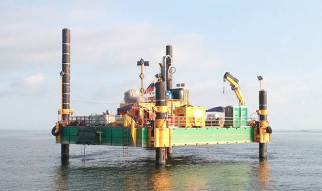
The Sandpiper (Callsign V3UA) will operate on a 24-hour daily basis commencing at the earliest from the Monday 14 May for approximately two weeks.
The Sandpiper is a non-self-propelled jack-up barge measuring 18.3m x 12.2m consisting of five Quadra pontoons and two duo pontoons with four 27m legs. The Sandpiper will be towed by the Trojan (Callsign EIEX6), a tug measuring 16m x 5m. Common frequency VHF Channel 16 shall be used throughout the project.
The survey will be conducted under Foreshore Licence FS006811, and is to collect geotechnical data utilising drilling spread only.
The nearshore survey activities will extend no more than 5km from the shoreline within a 500m area or corridor centred on the co-ordinates detailed in Marine Notice No 21 of 2018, a PDF of which is available to read or download HERE.


 was the Cruisers IRC Zero winner in Thursday's DBSC race")
