Menu

Ireland's sailing, boating & maritime magazine

Displaying items by tag: Commerce

3rd December 2009

Port of Belfast

Port of Belfast

The Port of Belfast is Northern Ireland's principal maritime gateway, serving the Northern Ireland economy and increasingly that of the Republic of Ireland. About 60% of Northern Ireland's seaborne trade and 20% of the entire island's is handled by the Port which receives over 6,000 vessels each year.

The Port is also a major centre of industry and commerce - its Harbour Estate is home to some of Northern Ireland's most important urban regeneration projects and it is the region's leading logistics and distribution hub.

With 1.2 million passengers and half a million freight units annually, Belfast is Ireland's busiest ferry port. It is also the island's leading dry bulk port, dominating the market with regard to imports of grain and animal feeds, coal, fertilisers and cement, and exports of scrap and aggregates. Over 95% of Northern Ireland's petroleum and oil products are also handled at the Port.
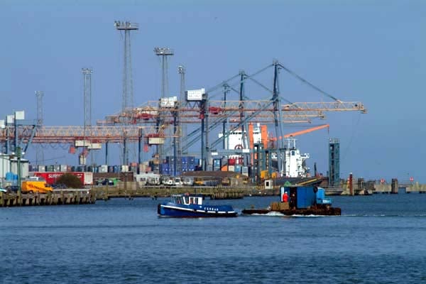
pob-cranes-03.jpg


History of the Port

The origins of the port in Belfast can be traced back to 1613, when, during the reign of James I, the town was incorporated as a borough by royal charter, with provision for the establishment of a wharf or quay. As a result, a quay was constructed at the confluence of the Rivers Fearset (Farset) and Lagan and the development of the Port of Belfast began.

Records show that by 1663 there were 29 vessels owned in the town with a total tonnage of 1,100 tonnes. Trade continued to expand throughout the century, to the extent that the original quay was enlarged, to accommodate the increasing number of ships.

By the early eighteenth century the town had replaced Carrickfergus as the most important port in Ulster and additional accommodation was considered necessary. A number of privately-owned wharves were subsequently constructed on reclaimed land. Throughout the century trade continued to expand as Belfast assumed a greater role in the trading activities of the country as a whole. In 1785 the Irish Parliament passed an act to deal with the town’s burgeoning port. As a result, a new body was constituted: The Corporation for Preserving and Improving the Port and Harbour of Belfast, commonly called “the Ballast Board”.

Although at this point the Port was well established it remained disadvantaged by the natural restrictions of shallow water, bends in the channel approach and inadequate quays. These problems, together with an increasing volume of trade, led to a new government act of 1837. This reconstituted the Board and gave it powers to improve the port, through the formation of a new channel. Initial work on straightening the river commenced in 1839 and by 1841 the first bend had been eliminated. The creation of what was to become the Victoria Channel had begun.

In 1847 the Belfast Harbour Act repealed previous acts and led to the formation of the Belfast Harbour Commissioners. This new body, with much wider powers, completed the second stage of the new channel two years later. From that time the Commissioners have developed and improved the Port, reclaiming land to accommodate new quays, new trades and changes in shipping and cargo-handling technology. The efficient, modern port of today is evidence of the foresight and commitment of successive generations of Harbour Commissioners.


Port of Belfast, Harbour Office, Corporation Square, Belfast, Northern Ireland BT1 3AL. Tel: 028 9055 4422

Commercial Contacts – Email: [email protected] • Tel: 028 9055 4422 • Fax: 028 9055 4420      
       
Marine Contacts – Email: [email protected] • Tel: 028 9055 4422 • Fax: 028 9055 3017      
       
Estate Contacts – Email: [email protected] • Tel: 028 9055 4422 • Fax: 028 9055 4411      
       
Corporate Contacts – Email: [email protected] • Tel: 028 9055 4422 • Fax: 028 9055 4420      
       
Human Resources – Email: [email protected] • Tel: 028 9055 4422 • Fax: 028 9055 4420

Harbour Police – Email: [email protected] • Tel: 028 9055 3000 • Fax: 028 9055 3001      
       
Harbour Safety – Email: [email protected] • Tel: 028 9055 4422 • Fax: 028 9055 3020      
       
Calls within the Belfast Harbour Police telephone system may be monitored or recorded

Published in Irish Ports

Cork Harbour Information

It’s one of the largest natural harbours in the world – and those living near Cork Harbour insist that it’s also one of the most interesting.

This was the last port of call for the most famous liner in history, the Titanic, but it has been transformed into a centre for the chemical and pharmaceutical industry.

The harbour has been a working port and a strategic defensive hub for centuries, and it has been one of Ireland's major employment hubs since the early 1900s. Traditional heavy industries have waned since the late 20th century, with the likes of the closure of Irish Steel in Haulbowline and shipbuilding at Verolme. It still has major and strategic significance in energy generation, shipping and refining.

Giraffe wander along its shores, from which tens of thousands of men and women left Ireland, most of them never to return. The harbour is home to the oldest yacht club in the world, and to the Irish Navy. 

This deep waterway has also become a vital cog in the Irish economy.

‘Afloat.ie's Cork Harbour page’ is not a history page, nor is it a news focus. It’s simply an exploration of this famous waterway, its colour and its characters.

Cork Harbour Festival

Ocean to City – An Rás Mór and Cork Harbour Open Day formerly existed as two popular one-day events located at different points on Cork’s annual maritime calendar. Both event committees recognised the synergy between the two events and began to work together and share resources. In 2015, Cork Harbour Festival was launched. The festival was shaped on the open day principle, with Ocean to City – An Ras Mór as the flagship event.

Now in its sixth year, the festival has grown from strength to strength. Although the physical 2020 festival was cancelled due to Covid-19, the event normally features nine festival days starting on the first week of June. It is packed full of events; all made possible through collaboration with over 50 different event partners in Cork City, as well as 15 towns and villages along Cork Harbour. The programme grows year by year and highlights Ireland’s rich maritime heritage and culture as well as water and shore-based activities, with Ocean to City – An Rás Mór at the heart of the festival.

Taking place at the centre of Ireland’s maritime paradise, and at the gateway to Ireland’s Ancient East and the Wild Atlantic Way, Cork is perfectly positioned to deliver the largest and most engaging harbour festival in Ireland.

The Cork Harbour Festival Committee includes representatives from Cork City Council, Cork County Council, Port of Cork, UCC MaREI, RCYC, Cobh & Harbour Chamber and Meitheal Mara.

Marinas in Cork Harbour

There are six marinas in Cork Harbour. Three in Crosshaven, one in East Ferry, one in Monkstown Bay and a new facility is opening in 2020 at Cobh. Details below

Port of Cork City Marina

Location – Cork City
Contact – Harbour Masters Dept., Port of Cork Tel: +353 (0)21 4273125 or +353 (0)21 4530466 (out of office hours)

Royal Cork Yacht Club Marina

Location: Crosshaven, Co. Cork
Contact: +353 (0) 21 4831023

Crosshaven Boatyard Marina

Location: Crosshaven, Co. Cork
Contact: +353 (0)21 4831161

Salve Marina Ltd

Location: Crosshaven, Co. Cork
Contact: +353 (0) 21 4831145

Cork Harbour Marina

Location: Monkstown, Co. Cork
Contact: +353 (0)87 3669009

East Ferry Marina

Location: East Ferry, Co. Cork
Contact: +353 (0)21 4813390

New Cove Sailing Club Marina

(to be opened in 2020)

Location: Cobh, Co. Cork
Contact: 087 1178363

Cork Harbour pontoons, slipways and ramps

Cork City Boardwalk Existing pontoon

Port of Cork 100m. pontoon

Cork city – End of Cornmarket St. steps and slip;

Cork city - Proby’s Qy. Existing limited access slip

Quays Bar & Restaurant, Private pontoon and ramp for patrons, suitable for yachts, small craft town and amenities

Cobh harbour [camber] Slip and steps inside quay wall pontoon

Fota (zoo, house, gardens) Derelict pontoon and steps

Haulbowline naval basin; restricted space Naval base; restricted access;

Spike Island pier, steps; slip, pontoon and ramp

Monkstown wooden pier and steps;

Crosshaven town pier, with pontoon & steps

East Ferry Marlogue marina, Slip (Great Island side) visitors’ berths

East Ferry Existing pier and slip; restricted space East Ferry Inn (pub)
(Mainland side)

Blackrock pier and slips

Ballinacurra Quay walls (private)

Aghada pier and slip, pontoon & steps public transport links

Whitegate Slip

Passage West Pontoon

Glenbrook Cross-river ferry

Ringaskiddy Parking with slip and pontoon Ferry terminal; village 1km.

Carrigaloe pier and slip; restricted space; Cross-river ferry;

Fountainstown Slip

White’s Bay beach

Ringabella beach

Glanmire Bridge and tide restrictions

Old Glanmire - Quay