Displaying items by tag: Coastal Notes
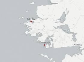
#Shipwrecks - Two new shipwrecks have been discovered in Connemara in areas known to be used by smugglers in centuries past, as The Irish Times reports.
Currach fisherman John Bhaba Jeaic Ó Conghaíle found the skeletal remains of what's thought to be an 18th-century vessel at Cuan Chaisín in Ceantar na nOileáin.
Elsewhere, Fahy Bay resident Michael Barry located a second wreck, believed to date from the 19th century, near his home on the northwest Connemara coast – inshore from the Spanish Armada wreck Falco Blanco Mediano.
The area is known as the birthplace of sea captain George O'Malley, one of the most notorious smugglers of his day.
The Irish Times has much more on the story HERE.
Portrush Lifeguard Aids Man Injured In Whiterocks Cliff Fall
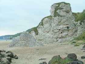
#CliffFall - An RNLI beach lifeguard aided a man who fell onto rocks while walking a steep cliff path on Whiterocks beach in Portrush yesterday afternoon (Wednesday 30 March).
The call for help came after a member of the group the man was with observed him fall just before 1pm and raised the alarm.
After arriving on scene, senior RNLI lifeguard Jamie Russell immediately began to administer casualty care to the conscious man, who had fallen some 12 feet from the coastal path. He was joined on scene by a paramedic and they continued to provide assistance.
However with an incoming tide and a challenging location, it was decided that removing the casualty would require the assistance of Coleraine coastguard.
The man was secured on a stretcher and carefully moved by the group around the rocks to a waiting ambulance.
Commenting on the callout, RNLI lifeguard supervisor Karl O’Neill said: "This incident was quite a challenging one to respond to due to the nature and location of the fall.
"Thankfully the man was conscious but we did not want to risk any further discomfort or injury by moving him ourselves. I would like to thank members of Coleraine coastguard for their assistance."
Whiterocks is one of five beaches being patrolled by RNLI lifeguard during the Easter holidays, continuing till Monday 4 April, as previously reported on Afloat.ie.
#DiverConcerns - The Environmental Protection Agency (EPA) has been called upon by divers to withdraw a permit issued to Dublin Port which allows it to dump “dredge spoil” off Dublin Bay, writes The Irish Times.
The Irish Underwater Council said the permit approved by the EPA was issued before designation of a special area of conservation (SAC) in Dublin Bay extending from Rockabill to Dalkey Island.
Dublin Port wants to carry out maintenance dredging on its main shipping route in April and intends to use an existing EPA permit which it applied for in 2009.
The port’s “spoil site” is on the edge of the Burford Bank, and it stresses that all material in the navigation channel is either uncontaminated or “slightly/moderately” contaminated.
It points out that such maintenance dredging has been routine since the early 1880s and is intended to ensure ships do not run aground approaching or leaving the port.
However, the Irish Underwater Council and diver Peadar Farrell contend that the EPA permit was issued before designation of the Rockabill to Dalkey Island SAC.
The Burford Bank spoil site 5km southeast of Howth lies within the SAC, the diving organisation points out.
For further coverage of this story, click here.
Mini Research Vessel Returns To The Sea
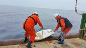
#CoastalNotes - Marine Institute researchers assisted marine technology students from Cape Fear Community College in the USA by deploying their miniature marine research vessel from the RV Celtic Explorer last Sunday 20 March.
The students in Cape Fear Community College’s boat building programme spent two months building Marlin Spikin’ Miller, which washed up on the shores of a Connemara island recently some eight months after being put to sea 6,000 miles across the Atlantic, as previously reported on Afloat.ie.
The boat is a miniature fibreglass sailboat designed to journey with the ocean winds and currents. It is embedded with a small satellite transmitter mounted on the deck and sends back data to the students which they use to monitor ocean and wind currents.
Cape Fear's boat building programme is unique in its kind and is part of a project in which a handful of schools across the USA are included.
Ciaran O’Donnell of the Marine Institute commented: “We are delighted to have this opportunity to play a role in this project and will look forward to seeing where the vessel will end up next.”
The Celtic Explorer launched the Marlin Spikin’ Miller at the most south-westerly point of the current blue whiting acoustic survey off the coast of Ireland.
The survey will run for another fortnight and will assess the size of the spawning stock of blue whiting in western waters. Ireland has participated in the international survey programme since 2004.
Acoustic data, age and maturity of blue whiting samples from all participants are combined to provide a measure of the relative abundance of the blue whiting stock.
The annual abundance estimate and stock numbers at age are presented to the ICES Working Group of Widely Distributed Stocks (WGWIDE).
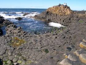
#Tourism - A number of waterside destinations feature in a new Lonely Planet list of the top 21 things to do in Ireland - just in time for the St Patrick's Festival.
TheJournal.ie has the lowdown on the tourism and travel guide's picks, which include the windswept coasts and breathtaking lakes of Connemara, the picturesque Dingle Peninsula, the 'unforgettable' Glendalough and the stunning sights around the Ring of Kerry.
And that's not to mention the rugged beauty of the Donegal coastline, the magnificence of the Causeway Coast and the remarkable history of Titanic Belfast.
Star Wars Shoot Coming To Malin Head? Not So Fast, Says Govt
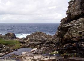
#StarWars - Rumours that Star Wars film crews are set to decamp for the Donegal coast are just that, as the Government department responsible has not confirmed permission.
According to TheJournal.ie, location scouts for Lucasfilm have been spotted in the Malin Head area searching for appropriately dramatic vistas for future instalments of the epic sci-fi film series.
But while Heritage Minister Heather Humphreys has confirmed that a "limited amount of filming" will take place on Sybil Head in Dingle later this year, no such permission has been granted for Donegal – and the minister would not comment on the existence of any talks over the same.
Star Wars fever has gripped the Kerry coast since last year as the Skelligs featured prominently in the smash hit blockbuster The Force Awakens.
But the filming has not been without its share of controversy over repairs to monastic ruins and alleged interference with protected seabird species at the Unesco World Heritage site.
More recently, a long-time guide on Skellig Michael spoke out over the State's facilitating of the two Lucasfilm shoots on the island for The Force Awakens and next year's sequel, as previously reported on Afloat.ie.
Galway Coast Gets New Volunteer Search Unit
#Galway - Galway Bay FM reports on a new volunteer search and rescue unit set up near the city weeks after community efforts to locate missing NUI Galway student Michael Bulger.
As previously reported on Afloat.ie, Bulger's body was recovered from the water near Oranmore on Galway Bay early last month after three weeks of searches largely driven by local volunteers.
Now the Oranmore-Maree Costal Search Unit, which will hold a public meeting on Monday week, hopes to harness those efforts across a 30km span of coastline split into nine zones with the co-operation of the Garda, Civil Defence and the RNLI.
Galway Bay FM has more on the story HERE.
Coastal Communities Integral To Any 'Blue Growth' Strategy Says UN Expert
#CoastalNotes - The rights of coastal communities involved in the likes of small-scale fishing and seaweed harvesting must be respected in any 'Blue Growth' strategy, a UN expert has said.
The Irish Times reports on comments made by UN fisheries chief Dr Rebecca Metzner upon her visit to Galway this week, where she heard the concerns of inshore fishermen who have protested against large-scale fish farming.
Local campaigners breathed relief in December when Bord Iascaigh Mhara (BIM) withdrew its application for what would have been the largest organic salmon farm in Europe, based off the Aran Islands in Galway Bay.
While recognising that aquaculture is required to "fill the gap" in the growing global demand for seafood, Dr Metzner emphasised that dialogue over shared access between local communities and larger commercial interests should be fundamental to any such plans.
She also heard from Connemara seaweed harvesters, who fear the loss of access to the coastline over legislation that may allow harvesting rights to be snapped up by much bigger State-owned enterprises – a situation the Government promised to review two years ago.
The Irish Times has more on the story HERE.
US College's Research Vessel Washes Up On Galway Island
#CoastalNotes - An American college's unmanned research vessel has been found on the shores of a Connemara island some eight months after students put it to sea 6,000 miles across the Atlantic in North Carolina.
As Port City Daily reports, the Cape Fear Community College (CFCC) vessel, appearing like a miniature sailboat, was discovered recently with its mast broken off on the coast of Illaunurra by kayaking father-and-son duo Keith and Graham Roberts.
Inside the boat, they found instructions on who to contact if it were recovered – which is how CFCC marine science teacher Jacqui Degan and her class learned the fate of their project.
Marlin Spikin’ Miller, as the boat was named, is one of two fibreglass boats kitted out with transmitters that the students set adrift south of Wilmington, North Carolina.
And that it survived its long-distance journey over many months relatively intact is a testament to the college's boatbuilding students, who collaborated with the science department on the project
Port City Daily has more on the story HERE.
'Poisonous Parsnips' Warning For NI Beaches
#CoastalNotes - 'Poisonous parsnips' on Co Antrim coastal beaches have prompted warnings to dog owners, as BelfastLive reports.
Warning signs were put up at Ballygally, Carnfunnock and Drains Bay earlier this month after locals found evidence of hemlock water dropwort roots, which are extremely toxic to animals – particularly at this time of year.
It's thought that the plant is previously responsible for the death of at least one dog that tried to eat one at Drains Bay in 2014.
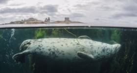
In other recent news from Northern Ireland, a seal spotted swimming in the River Lagan has been hailed as a sign of its good water quality.
Video of what appears to be a grey seal happily bobbing along upstream near the Ormeau Embankment was captued by Belfast man Brendan McNeice, who thought the sight "unusual".
But marine wildlife expert Tanya Singleton told UTV News that seals swimming so far up the river is actually a regular occurrence – and a good sign for the waterway's health as they chase booming fish stocks as far as Lisburn.


