Menu

Ireland's sailing, boating & maritime magazine

Dublin Bay Boating News and Information

Displaying items by tag: Storm Hector

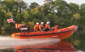
#RNLI - Enniskillen RNLI rescued two people on Lower Lough Erne after their 42ft cruiser broke free from its jetty during Storm Hector yesterday morning (Thursday 14 June).

Belfast Coastguard requested the launch of the inshore lifeboat at 6.42am, with the volunteer crew proceeding north to the stricken vessel close to the shoreline south of Rossigh.

With increasing winds through the night, the vessel had broken free from its mooring and some of the jetty was still secured to the boat.

The winds were starting to settle but they were estimated to be Force 6 or 7 when launching from the Lough Erne Yacht Club.

The lifeboat managed to refloat the vessel and brought it into safer water. The hire company then took charge of the cruiser with the lifeboat accompanying them to a sheltered location.

“With challenging conditions this morning the crews training was put into action and brought the two people and vessel to safety,” said Gary Jones, Enniskillen RNLI’s lifeboat operations manager.

Elsewhere, pagers sounded across the Irish Sea at Holyhead RNLI just after midnight on Thursday in the midst of the storm, with reports of an 18-metre yacht with mechanical failure west of the Skerries lighthouse off Anglesey.

At the scene, the lifeboat crew found the 60-tonne vessel, with two on board, had lost all power and was struggling to cope with the weather conditions, including southerly gale-force winds and spring tides.

The lifeboat undertook a tow of the stricken yacht, which was returning from the Isle of Man TT races back to her mooring at Holyhead. Both vessels arrived safely in port at 4.30am.

Speaking on behalf of Holyhead RNLI, press officer Vicki Owens said: “The weather was unseasonably rough, but our dedicated crew left their beds to help someone in trouble.”

The surprise Storm Hector was also responsible for blowing a yacht ashore on the Kerry coast, as previously noted on Afloat.ie.

Published in RNLI Lifeboats

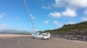
#StormHector - One sorry yacht owner felt the wrath of Storm Hector today (Thursday 14 June) when their vessel was founded beached near Waterville in Co Kerry, as RTÉ News reports.

The Hanse yacht, named Seabiscuit, broke its mooring in Ballinskelligs Bay and was blown ashore on Inny Strand below Waterville Golf Course amid severe gusts that were forecast to reach as high as 125kmh overnight.

A Status Yellow small craft warning remains in effect on coasts from Hook Head to Erris Head to Howth Head with west to southwest winds reaching Force 6 or higher.

Published in Coastguard
Tagged under

Dublin Bay

Dublin Bay on the east coast of Ireland stretches over seven kilometres, from Howth Head on its northern tip to Dalkey Island in the south. It's a place most Dubliners simply take for granted, and one of the capital's least visited places. But there's more going on out there than you'd imagine.

The biggest boating centre is at Dun Laoghaire Harbour on the Bay's south shore that is home to over 1,500 pleasure craft, four waterfront yacht clubs and Ireland's largest marina.

The bay is rather shallow with many sandbanks and rocky outcrops, and was notorious in the past for shipwrecks, especially when the wind was from the east. Until modern times, many ships and their passengers were lost along the treacherous coastline from Howth to Dun Laoghaire, less than a kilometre from shore.

The Bay is a C-shaped inlet of the Irish Sea and is about 10 kilometres wide along its north-south base, and 7 km in length to its apex at the centre of the city of Dublin; stretching from Howth Head in the north to Dalkey Point in the south. North Bull Island is situated in the northwest part of the bay, where one of two major inshore sandbanks lie, and features a 5 km long sandy beach, Dollymount Strand, fronting an internationally recognised wildfowl reserve. Many of the rivers of Dublin reach the Irish Sea at Dublin Bay: the River Liffey, with the River Dodder flow received less than 1 km inland, River Tolka, and various smaller rivers and streams.

Dublin Bay FAQs

There are approximately ten beaches and bathing spots around Dublin Bay: Dollymount Strand; Forty Foot Bathing Place; Half Moon bathing spot; Merrion Strand; Bull Wall; Sandycove Beach; Sandymount Strand; Seapoint; Shelley Banks; Sutton, Burrow Beach

There are slipways on the north side of Dublin Bay at Clontarf, Sutton and on the southside at Dun Laoghaire Harbour, and in Dalkey at Coliemore and Bulloch Harbours.

Dublin Bay is administered by a number of Government Departments, three local authorities and several statutory agencies. Dublin Port Company is in charge of navigation on the Bay.

Dublin Bay is approximately 70 sq kilometres or 7,000 hectares. The Bay is about 10 kilometres wide along its north-south base, and seven km in length east-west to its peak at the centre of the city of Dublin; stretching from Howth Head in the north to Dalkey Point in the south.

Dun Laoghaire Harbour on the southside of the Bay has an East and West Pier, each one kilometre long; this is one of the largest human-made harbours in the world. There also piers or walls at the entrance to the River Liffey at Dublin city known as the Great North and South Walls. Other harbours on the Bay include Bulloch Harbour and Coliemore Harbours both at Dalkey.

There are two marinas on Dublin Bay. Ireland's largest marina with over 800 berths is on the southern shore at Dun Laoghaire Harbour. The other is at Poolbeg Yacht and Boat Club on the River Liffey close to Dublin City.

Car and passenger Ferries operate from Dublin Port to the UK, Isle of Man and France. A passenger ferry operates from Dun Laoghaire Harbour to Howth as well as providing tourist voyages around the bay.

Dublin Bay has two Islands. Bull Island at Clontarf and Dalkey Island on the southern shore of the Bay.

The River Liffey flows through Dublin city and into the Bay. Its tributaries include the River Dodder, the River Poddle and the River Camac.

Dollymount, Burrow and Seapoint beaches

Approximately 1,500 boats from small dinghies to motorboats to ocean-going yachts. The vast majority, over 1,000, are moored at Dun Laoghaire Harbour which is Ireland's boating capital.

In 1981, UNESCO recognised the importance of Dublin Bay by designating North Bull Island as a Biosphere because of its rare and internationally important habitats and species of wildlife. To support sustainable development, UNESCO’s concept of a Biosphere has evolved to include not just areas of ecological value but also the areas around them and the communities that live and work within these areas. There have since been additional international and national designations, covering much of Dublin Bay, to ensure the protection of its water quality and biodiversity. To fulfil these broader management aims for the ecosystem, the Biosphere was expanded in 2015. The Biosphere now covers Dublin Bay, reflecting its significant environmental, economic, cultural and tourism importance, and extends to over 300km² to include the bay, the shore and nearby residential areas.

On the Southside at Dun Laoghaire, there is the National Yacht Club, Royal St. George Yacht Club, Royal Irish Yacht Club and Dun Laoghaire Motor Yacht Club as well as Dublin Bay Sailing Club. In the city centre, there is Poolbeg Yacht and Boat Club. On the Northside of Dublin, there is Clontarf Yacht and Boat Club and Sutton Dinghy Club. While not on Dublin Bay, Howth Yacht Club is the major north Dublin Sailing centre.

© Afloat 2020