Menu

Ireland's sailing, boating & maritime magazine

Dublin Bay Boating News and Information

Displaying items by tag: drumshanbo

#blueway – Minister Heather Humphreys TD, and actor & producer Carrie Crowley joined with over 300 walkers and paddlers to open the Shannon Blueway today in Drumshanbo, Co Leitrim.
As previously reported on Afloat.ie, the Shannon Blueway runs from Drumshanbo through Battlebridge and Leitrim Village to Carrick on Shannon. It includes 16.5km of water trail and over 10km of walking routes in three loops. The Shannon Blueway provides a range of recreational leisure activities such as walking, cycling, canoeing, fishing and cruising all linked by the waterways to local towns and villages.
Minister Heather Humphrey's stated "I am delighted to be launching this project here in Leitrim today. The Shannon Blueway has the potential to have a very positive impact on jobs and the regional economy. The Mayo Greenway, which is now in its 4th year of operation, has seen a jump in visitor numbers from 80,000 in 2011 to 300,000 in 2014. That means an extra €5 million was brought into the region. With the market for off road adventure tourism is growing here in Ireland and internationally, Leitrim is in a prime position to benefit from this trend.
The launch of the Blueway will allow local businesses can capitalise on an increase in demand for transport, equipment hire, accommodation and entertainment. I would like to commend Waterways Ireland for this initiative, which I have no doubt will have a very position impact on the region."
Carrie Crowley said "as a self-confessed blow-in to the area, the Shannon, the wonderful countryside and Leitrim people have provided me with a tranquil and inspirational place to work and home away from home .The only problem is, now our secret is out!"
The Shannon Blueway is the first of its kind in Ireland where a myriad of recreational activities have been developed and bundled together as a single or multiple visitor experience and tourism proposition. Waterways Ireland has, using the wonderful waterway assets, developed and built a canoe trail from Drumshanbo through Battlebridge and Leitrim Village to Carrick on Shannon. It has also developed a series of looped walks adjacent to the Lough Allen Canal with plans to expand those walks to Drumshanbo and Carrick on Shannon. At the same time Waterways Ireland is also developing a canoe trail from Leitrim Village along the 63km of the Shannon Erne Waterway with a walking and cycling trail also at an advanced stage of planning.
The Shannon Blueway is being delivered by Waterways Ireland in partnership of the National Trails Office, Canoeing Ireland, Leitrim County Council, Leitrim Tourism and Fáilte Ireland.

shannon_blueway_leitrim3.jpg

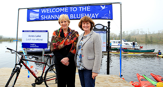
Minister Heather Humphreys TD, and WI Chief Executive Dawn Livingstone 

Chief Executive Dawn Livingstone confirmed that partnership was the key to delivering the Shannon Blueway "Waterways Ireland has invested significantly in creating world beating facilities and services on the Shannon Navigation. Through our partnership with the National Trails Office, Canoeing Ireland, Leitrim Tourism and Leitrim County Council an outstanding multi-activity product has been built in the Shannon Blueway which is now being packaged by clubs and communities for their recreational activities and companies and organisations for domestic and international tourists. Partnership is key to delivering the future of the Shannon Blueway further into Leitrim, and indeed into Roscommon, Longford and Cavan."
The wider Shannon Blueway of which the Drumshanbo to Carrick on Shannon section is part, is at the heart of access to 100km of paddling area, 6 looped walks: 3 of which are on the canal towpath, two long distance walks and three heritage trails. The Shannon Blueway will ultimately provide access to 14 towns and services with each access point and town within an hours' paddling time.

shannon_blueway_leitrim2.jpg

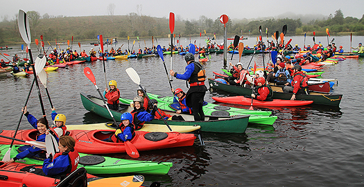
300 paddlers joined the ShannonBlueway launch

Waterways Ireland and Leitrim Co Co will shortly be examining the possibility of providing a connection from the jetties at Acres Lake to the canal towpaths and also to complete the walking/cycling connection to Carrick-on-Shannon, and up the Shannon-Erne Waterway.

Published in Inland Waterways

Shannon Navigation Lough Allen Drumshanbo Jetty Sunken Vessel

Waterways Ireland wishes to advise masters on the inland waterways that a vessel has sunk at the north end of Drumshanbo Lock jetty and poses a hazard to any vessel approaching or departing the jetty. Masters are requested to seek advice from the lockkeeper before berthing and to navigate with due caution.

Charles Lawn
Lt Cdr (rtd)
Inspector of Navigation
12 Jan 2011
Tel: 00 353 (0)90 6494232

Published in Inland Waterways

Dublin Bay

Dublin Bay on the east coast of Ireland stretches over seven kilometres, from Howth Head on its northern tip to Dalkey Island in the south. It's a place most Dubliners simply take for granted, and one of the capital's least visited places. But there's more going on out there than you'd imagine.

The biggest boating centre is at Dun Laoghaire Harbour on the Bay's south shore that is home to over 1,500 pleasure craft, four waterfront yacht clubs and Ireland's largest marina.

The bay is rather shallow with many sandbanks and rocky outcrops, and was notorious in the past for shipwrecks, especially when the wind was from the east. Until modern times, many ships and their passengers were lost along the treacherous coastline from Howth to Dun Laoghaire, less than a kilometre from shore.

The Bay is a C-shaped inlet of the Irish Sea and is about 10 kilometres wide along its north-south base, and 7 km in length to its apex at the centre of the city of Dublin; stretching from Howth Head in the north to Dalkey Point in the south. North Bull Island is situated in the northwest part of the bay, where one of two major inshore sandbanks lie, and features a 5 km long sandy beach, Dollymount Strand, fronting an internationally recognised wildfowl reserve. Many of the rivers of Dublin reach the Irish Sea at Dublin Bay: the River Liffey, with the River Dodder flow received less than 1 km inland, River Tolka, and various smaller rivers and streams.

Dublin Bay FAQs

There are approximately ten beaches and bathing spots around Dublin Bay: Dollymount Strand; Forty Foot Bathing Place; Half Moon bathing spot; Merrion Strand; Bull Wall; Sandycove Beach; Sandymount Strand; Seapoint; Shelley Banks; Sutton, Burrow Beach

There are slipways on the north side of Dublin Bay at Clontarf, Sutton and on the southside at Dun Laoghaire Harbour, and in Dalkey at Coliemore and Bulloch Harbours.

Dublin Bay is administered by a number of Government Departments, three local authorities and several statutory agencies. Dublin Port Company is in charge of navigation on the Bay.

Dublin Bay is approximately 70 sq kilometres or 7,000 hectares. The Bay is about 10 kilometres wide along its north-south base, and seven km in length east-west to its peak at the centre of the city of Dublin; stretching from Howth Head in the north to Dalkey Point in the south.

Dun Laoghaire Harbour on the southside of the Bay has an East and West Pier, each one kilometre long; this is one of the largest human-made harbours in the world. There also piers or walls at the entrance to the River Liffey at Dublin city known as the Great North and South Walls. Other harbours on the Bay include Bulloch Harbour and Coliemore Harbours both at Dalkey.

There are two marinas on Dublin Bay. Ireland's largest marina with over 800 berths is on the southern shore at Dun Laoghaire Harbour. The other is at Poolbeg Yacht and Boat Club on the River Liffey close to Dublin City.

Car and passenger Ferries operate from Dublin Port to the UK, Isle of Man and France. A passenger ferry operates from Dun Laoghaire Harbour to Howth as well as providing tourist voyages around the bay.

Dublin Bay has two Islands. Bull Island at Clontarf and Dalkey Island on the southern shore of the Bay.

The River Liffey flows through Dublin city and into the Bay. Its tributaries include the River Dodder, the River Poddle and the River Camac.

Dollymount, Burrow and Seapoint beaches

Approximately 1,500 boats from small dinghies to motorboats to ocean-going yachts. The vast majority, over 1,000, are moored at Dun Laoghaire Harbour which is Ireland's boating capital.

In 1981, UNESCO recognised the importance of Dublin Bay by designating North Bull Island as a Biosphere because of its rare and internationally important habitats and species of wildlife. To support sustainable development, UNESCO’s concept of a Biosphere has evolved to include not just areas of ecological value but also the areas around them and the communities that live and work within these areas. There have since been additional international and national designations, covering much of Dublin Bay, to ensure the protection of its water quality and biodiversity. To fulfil these broader management aims for the ecosystem, the Biosphere was expanded in 2015. The Biosphere now covers Dublin Bay, reflecting its significant environmental, economic, cultural and tourism importance, and extends to over 300km² to include the bay, the shore and nearby residential areas.

On the Southside at Dun Laoghaire, there is the National Yacht Club, Royal St. George Yacht Club, Royal Irish Yacht Club and Dun Laoghaire Motor Yacht Club as well as Dublin Bay Sailing Club. In the city centre, there is Poolbeg Yacht and Boat Club. On the Northside of Dublin, there is Clontarf Yacht and Boat Club and Sutton Dinghy Club. While not on Dublin Bay, Howth Yacht Club is the major north Dublin Sailing centre.

© Afloat 2020