Displaying items by tag: Marine Science News
Sir David Attenborough Lays Keel for New £150m Polar Research Ship
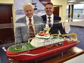
#BoatyMcBoatface - Sir David Attenborough along with more than 1,000 people attended the keel-laying ceremony of a new £150m polar research vessel at a UK shipyard yesterday.
Construction of RSS Sir David Attenborough was officially started by the world-renowned naturalist and broadcaster, after whom the ship is named. Noting earlier this year the public through an online poll originally had chosen a different name 'Boaty McBoatface' as a clear favourite that proved controversial. The newbuild's robotic underwater vehicle will however be named 'Boaty McBoatface'.
At the ceremonial event at Cammell Laird's shipyard site, Birkenhead in Liverpool City Region, Sir David started the “keel laying” process by initiating the lifting by crane of the first hull unit on to the construction berth. This unit, weighing around 100 tonnes, includes part of the ship’s keel and is the first of 97 units which will be erected to form the entire hull of the research ship.
When the ship sets sail in 2019, the RRS Sir David Attenborough will provide a research base to help scientists tackle some of the most important issues facing humanity, including climate change, future sea level rise and the impact of environmental change on marine life.
Speaking at the ceremony Sir David Attenborough said: “It is an honour to be invited to take part in the keel-laying ceremony. The Polar Regions are not only critical for understanding the natural world but they also have an enormous appeal for journalists, broadcasters and the public.
“I have had several opportunities to experience the power of these places first hand. This new ship will ensure that scientists have access to these enigmatic regions to uncover secrets that we can only imagine at this point. Scientists working on this new ship will inform everyone about our changing world for generations to come.”
New Centre Beaufort Promises Major Maritime Investment
#NewCentre – The Examiner writes that over the weekend, a maritime facility which will power the 'blue economy" was opened in Ringaskiddy, Co Cork, by Taoiseach Enda Kenny.
The 4,700m sq, five-storey Beaufort Building with wave simulators, test tanks, workshops and offices provides Ireland with world-class infrastructure for renewable energy and maritime research.
Named after the Irish hydrographer and globally adopted Beaufort Wind Scale creator, Rear Admiral Francis Beaufort, the Beaufort building will house the headquarters of the multi-institutional home to Science Foundation Ireland's Marine Renewable Energy Ireland and the LIR National Ocean Test Facility.
For more on this new facility located in lower Cork Harbour, the newspaper has a report here.
The Blue Economy: Business Breakfast Hosted by Cork Chamber
#BlueEconomy - Dr Peter Heffernan, CEO of the Marine Institute is to be the guest speaker of Cork Chamber's June Business Breakfast on Thursday 25th June in the Clarion Hotel.
The Blue Economy is seen as hugely important for the island of Ireland and Cork is naturally well positioned to reap the benefits of this growth, boasting the second largest natural harbour in the world. Focused around the Ringaskiddy area, the Irish Maritime Research Cluster (IMERC) are at the centre of promoting Ireland as a world renowned maritime and research development location.
It is also the site of the National Maritime College of Ireland, the Irish Naval Service and the UCC Beaufort Laboratory.
Dr Peter Heffernan was appointed as CEO of the Marine Institute in 1994. The Marine Institute is Ireland's National agency for marine Research Technology Development & Innovation (RTDI).
Dr Heffernan obtained PhD in marine science from the National University of Ireland, Galway. He held a post-doctoral position at University of Georgia (USA) in 1985, he has published over 40 scientific papers, has over 20-years of experience in leading marine science policy developments at national, EU and trans-Atlantic levels.
This is an opportunity for Chamber members to get an insight into the huge potential in the marine industry in Ireland and in particular, in the Southern Region.
Members of the public are also invited to the Cork Chamber event where further information, registration and event times are available through this website link HERE.
#SeaforSociety - An open day saw more than 150 children from five schools from Dublin, Cork, Galway, and Mayo visit the Marine Institute's research vessel, the RV Celtic Explorer, as well as Galway Atlantaquaria, as part of the EU FP7 Sea for Society project to raise awareness of our ocean, this week in Galway city.
The Sea for Society collective action aims to shape the concept of a "Blue Society" and improve Europe's understanding on the relation between the ocean and our daily life activities. "As part of the Sea for Society FP7 project in Ireland, we provided the opportunity for children to see and take part in a wide range of activities including meeting with marine scientists, researchers and the Captain of the RV Celtic Explorer, as well as the team from AquaTT and marine experts at the aquarium," explained Cushla Dromgool-Regan, Marine Institute.
On the vessel the children meet with the fisheries research team who showed a wide range of fish from the deep ocean. The seabed mapping researchers showed bathymetry mapping images of key shipwrecks around Ireland as well as the newly discovered submarine mountain ranges mapped by the RV Celtic Explorer on its latest expedition from Newfoundland to Galway.
The remotely operated vehicle ROV Holland I, which is to be used in the vessels next expedition filming cold water corals on the Porcupine bank, was also on display. This
provided a key opportunity for the children to learn about marine history, marine technology well as taking part in some simple experiments demonstrating pressure.
AquaTT also asked the teachers and children to think about the small changes we can make in our lifestyle which have a significant impact on the ocean, such as using less water, eating fish that has been caught sustainably, disposing plastics in a responsible way, to taking part in beach cleans.
Galway Atlantaquaria provided tactile learning opportunities where the students got to touch and see marine animals native to Irish seashores and ocean.
Teachers and pupils alike described the event as a unique and wonderful experience. "I've attended many trips with the school, but this one really stood out. We learned so much, ranging from how phytoplankton in our ocean provide up to 50 percent of the oxygen we breathe, to how to tell the age of a fish using their ear bones - otoliths. Raising awareness of our ocean and the impact that the ocean has on us is so important," said Maire Ni Fhoghlu, from Gaelscoil Uileog de Burca, Claremorris.
The children who attended the open day had taken part in the Marine Institute's Explorers Education Programme which is run by Galway Atlantaquaria, Blackrock Education Centre, SeaLife – Bray and Lifetime Lab in Cork, and is also supported by other education centres in Mayo and Galway.
"The excellent marine activities and projects completed this year by the schools were evident by the enthusiasm and knowledge of the children who visited the Celtic Explorer. For an island nation it is heartening to see that the children are learning about our ocean, understanding the importance of scientific marine research as well as taking personal responsibility for caring for our marine environment," Cushla Dromgool-Regan further said.
The Explorers Education programme also provides a range of cross curricular teaching resources and lesson plans for all primary schools to freely download at www.explorers.ie
In addition for more details on the programme details click HERE.
UCC Given Go Ahead of Major Maritime Research Centre
#NewUCCcentre – According to a report in the Irish Examiner, University College Cork has been granted permission to facilitate site works for the development of a major maritime research centre on the southside of Cork harbour.
The university applied at the end of July for the works, on a site of 15 acres next to Cork Institute of Technology's National Maritime College of Ireland, (which held it's Open Day on Tuesday this week) in Ringaskiddy.
The development also adjoins the under-construction Beaufort Laboratory, for which permission was given on foot of a 2011 application to Cork County Council. For more details among a series of projects listed under planning notes, click HERE.
INFOMAR Seminar Heads for Waterford City
#INFOMARseminar- The annual INFOMAR Seminar is to take place in Waterford City over the course of two-days (22-23 October) at the Tower Hotel opposite the city's landmark Reginald Tower.
The seminar will include an update on Ireland's national seabed mapping programme featuring survey operations and coverage, future plans, associated research along with poster sessions. To register for a free place at the seminar, click HERE
INFOMAR which stands for The INtegrated Mapping FOr the Sustainable Development of Ireland's MArine Resource programme is a joint venture between the Geological Survey of Ireland and the Marine Institute.
An area covering some 125,000 km2 of Ireland's most productive and commercially valuable inshore waters is carried out by INFOMAR. They produce integrated mapping products covering the physical, chemical and biological features of the seabed.
The following research vessels operate for INFORMAR the RV Keary, Geo and Cosantóir Bradán.
#UnderwaterWaterford – Following our port snapshot of Waterford Harbour shipping this morning which included a dredger, INFOMAR takes us on a 3D-fly-through of the estuary (in reverse direction) showing the seabed as its winds its way upriver to the city, writes Jehan Ashmore.
The 3D imagery shows (click link, scroll down and enlarge video) the varying depths and channel widths of the shipping lane along Waterford estuary taken from the research vessel, the RV Keary.
As mentioned above this is where a dredging campaign is currently underway, notably for ships using Belview Por, the main terminal facility of the Port of Waterford Company which has contracted WD Mersey (1983/1,696grt) to carry out the work.
Since late last month dredging operations along the estuary has involved the spoil to be dumped south-west off Hook Head.
As for the role of RV Keary this took place in 2011 and was the first INFOMAR survey leg to be carried out by the South African built aluminium constructed catamaran. The survey took two-months to complete and was conducted in preparation to hosting the second Tall Ships Festival held that year.
The seabed survey mapping of RV Keary concentrated on the navigational channel while the surrounding shallower waters were tasked to a smaller RIB based craft, RV Geo. Together this was the first occasion the pair of GSI vessels worked on a survey.
The 15m RV Keary is a state-run marine research survey vessel commissioned for and operated by the Geological Survey of Ireland (GSI). As reported in 2012, the Central Fisheries Board cutter Cosantoir Bradan was chartered by GSI in an RV role.
The vessels primary function is to provide an inshore survey capability for the national INtegrated Mapping FOr the Sustainable Development of Ireland's MArine Resource - in short INFOMAR.
In addition assistance in the INFOMAR programme which is funded by the Department of Communications, Energy and Natural Resources, is also made available from the Marine Institute's pair of research vessels, RV Celtic Voyager and larger fleetmate RV Celtic Explorer.
To keep track of GSI vessels current locations, click this map-link.
EurOCEAN 2014 during Italian-EU Presidency Conference
#EurOCEAN – CEO of the Marine Institute, Dr Peter Heffernan yesterday welcomed the announcement of the EurOCEAN 2014 Conference in Rome recalling the very successful EurOCEAN 2004 Galway Conference and the 2004 Galway Declaration on Marine Science & Technology.
The Galway Declaration, and subsequent EurOCEAN Conference Declarations (Aberdeen, 2007 and Ostend, 2010), have made significant contributions to the EU's Marine Research Agenda and the Integrated Maritime Policy for the European Union (2007). He looked forward to an equally influential Declaration from the Rome Conference.
EurOCEAN 2014 (7th – 9th October 2014, Rome) will bring together marine scientists across the broad range of disciplines with policymakers, industry and NGOs, to develop a common vision on achieving an ecosystem approach to the management of Europe's marine resources as a fundamental requirement for sustainable Blue Growth. Highlighting the importance of Blue Growth and of commercially-driven, problem-oriented research, EurOCEAN 2014 will equally emphasize that a growing and sustainable maritime economy will also require a much greater knowledge and understanding of marine ecosystem functioning and resilience.
For 2.5 days EurOCEAN 2014 cover a combination of plenary sessions and parallel workshops, organized around societal, policy and regional challenges. The conference programme will reflect the high-level messages of the European Marine Board's Navigating the Future-IV Foresight Report.
The EurOCEAN 2014 conference is part of the successful EurOCEAN Conference Series initiated in late 1990s to provide a regular focal point for the marine and maritime research community and stakeholders to interact with European and member state policymakers and programme managers, to discuss and respond to new marine science and technology developments, challenges and opportunities.
EurOCEAN 2014 is an official event of the Italian EU Presidency and is co-organized by the European Marine Board, European Commission and the Italian EMB members, CNRS, OGS and CoNISMA.
For further information see: http://eurocean2014.eu/
INFOMAR Annual Seminar 2013
#INFOMARseminar – A two-day INFOMAR seminar hosted by the Geological Survey of Ireland and the Marine Institute is to start tomorrow (Wednesday 9 October) in Limerick City.
Integrated Mapping for the Sustainable Development of Ireland's Marine Resources (INFOMAR) is a joint venture between the Geological Survey of Ireland and the Marine Institute. The programme is the successor to the Irish National Seabed Survey.
INFOMAR covers some 125,000 km² of Irelands most productive and commercially valuable inshore waters.
The annual INFOMAR conference will see seminar delegates meet in the Pavilion of the University of Limerick (UL) which is to be hosted by the Mobile & Marine Robotics Research Centre.
The seminar will include an update on Ireland's national seabed mapping programme including survey operations and coverage, future plans, associated research along with poster sessions.
Places to attend the free seminar were made open to all, however registration has now closed as attendance is at capacity.
To request a late registration, contact Kevin Sheehan by email: [email protected], should places become available.
For further information visit: www.eventelephant.com/infomarannualseminar2013
Scientific Ship-Time Applications Now Open for 2014-2015
#ResearchShipTime – The Marine Institute are calling for applications for those wishing to accept ship-time on board the research vessels RV Celtic Explorer and RV Celtic Voyager in 2014 and 2015.
Applications for ship-time must be submitted using Research Vessel Operations' on-line 'Survey Planning System' (SPS) before 20th September 2013.
Applicants can get further information from the Apply for Ship-time pageApplications for ship-time must be submitted using Research Vessel Operations' on-line 'Survey Planning System' (SPS) before 20th September 2013.
Applicants can get further information from the Apply for Ship-time page on the Marine Institute website www.marine.ie and contact [email protected] to obtain login details to SPS.
Applicants should read The Vessel Charter Guidelines (.doc 256 KB) prior to submitting their application.
Applicants may seek grant-aid to cover all or part of the vessel charter costs.
For information on eligibility for grant-aid and additional application requirements please refer to the Grant-Aid Guidelines
Note: Applications for grant-aid will only be accepted for ship-time in 2014. Applications for grant-aid for ship-time in 2015 will be accepted in 2014.
Persons considering making an application for shiptime for training purposes are advised to consult with Strategic Marine Alliance for Research and Training (SMART) via [email protected].
This marine science partnership programme is designed to standardise and optimise ship based training for 3rd level students and provide nationally accredited ship based training activities.
The RV Celtic Explorer will once again be making transatlantic passages to complete a survey in Newfoundland waters in April 2014 (Westward) and May (Eastward) and a targeted call for applications to utilise these transects is being included in this year's call.
Applications are invited from researchers to utilise to utilise the vessel for up to a 14 day period on the western transect starting in mid-April 2014.
The initiative is planned to coincide with a planned charter survey in Newfoundland waters in April/May 2014 and is a precursor to future transatlantic co-operative research as outlined at the recent Atlantic Strategy meeting which included EU, US and Canadian Partners.
The PIP funding scheme will accept proposals for part funding of shiptime and full funding of associated research. For further information please go to their website: http://www.pip.ie/page/1


