Menu

Ireland's sailing, boating & maritime magazine

Displaying items by tag: Navigation

The latest Marine Notice from the Department of Transport, Tourism and Sport details the training requirements for the use of Electronic Chart Display and Information Systems (ECDIS) as a primary means of navigation.
Mandatory carriage requirements for ECDIS will be phased in between 1 July 2012 and 1 July 2018 according to ship size and class. All shipowners, masters and deck officers of merchant and fishing vessels, yachtsmen, nautical colleges and other users are required to complete both generic and ship specific training for the use of ECDIS.
The notice outlines the following as meeting the requirements for generic training:
- A NARAS Operational course completed after 1 January 2005.
- An ECDIS programme based on the IMO Model ECDIS course (1.27) approved by the Irish Maritime Administration.
- An ECDIS programme based on the IMO Model ECDIS course (1.27) approved by the maritime administration of an EU Member State or by a country recognised by Ireland under STCW 78.
As far as ship-specific training, the following areas should be covered in training delivered by the ECDIS manufacturer (computer-based training packages are acceptable):
- familiarisation with available functions
- familiarisation with the menu structure
- display setup
- setting of safety values
- recognition of alarms and malfunction indicators and the actions to be taken
- route planning
- route monitoring
- changing over to backup systems
- loading charts and licenses
- updating of software
Further details are available in Marine Notice No 51 of 2011, available to read or download as a PDF HERE.

The latest Marine Notice from the Department of Transport, Tourism and Sport details the training requirements for the use of Electronic Chart Display and Information Systems (ECDIS) as a primary means of navigation.

Mandatory carriage requirements for ECDIS will be phased in between 1 July 2012 and 1 July 2018 according to ship size and class. All shipowners, masters and deck officers of merchant and fishing vessels, yachtsmen, nautical colleges and other users are required to complete both generic and ship specific training for the use of ECDIS.

The notice outlines the following as meeting the requirements for generic training:

  • A NARAS Operational course completed after 1 January 2005.
  • An ECDIS programme based on the IMO Model ECDIS course (1.27) approved by the Irish Maritime Administration. 
  • An ECDIS programme based on the IMO Model ECDIS course (1.27) approved by the maritime administration of an EU Member State or by a country recognised by Ireland under STCW 78.

As far as ship-specific training, the following areas should be covered in training delivered by the ECDIS manufacturer (computer-based training packages are acceptable): 

  • familiarisation with available functions
  • familiarisation with the menu structure
  • display setup
  • setting of safety values
  • recognition of alarms and malfunction indicators and the actions to be taken
  • route planning
  • route monitoring
  • changing over to backup systems
  • loading charts and licenses
  • updating of software

Further details are available in Marine Notice No 51 of 2011, available to read or download as a PDF HERE.

Published in News Update

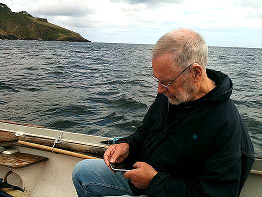
Dag Pike talks us through the fact the ubiquitous IPhone will do nearly anything that you ask it to and it even makes phone calls. Much of what it does is related to land-based applications but now the boundaries are becoming blurred and the IPhone can become a wonderful navigation device for use at sea.

I am sure that many of you have already discovered the virtues of the IPhone and the more I use it for navigation, the more I discover what it will do. The problem is to narrow down what you want the phone to do rather than being distracted by the wide variety of applications on offer that will run your life if you let them.
dagnav

Certainly the IPhone is the most complete navigation tool ever invented. In one tiny unit, it offers communication, navigation charting and positioning, compass, tides and currents, AIS, and even a log book, all at the touch of a button. As far as I can work out, there are only two things missing from the navigation repertoire of the IPhone. One is radar, and there really is no way around that one, and the second is a depth sounder and the only way that you might get that information from the IPhone would be to tie it onto a piece of string and drop it overboard! Everything or at least nearly everything else you might need for navigation is contained in the one small portable package.

It sounds too good to be true and in some ways it is. Being a small portable package makes it vulnerable. You might drop it, you might loose it, you might have a flat battery, or it might just stop working, so you could be vulnerable if you put all your trust into this one unit. For many, there has been safety in the philosophy of having each navigation requirement contained in a separate unit, then if one fails then you still have the other to keep you going. I would be very nervous about putting all my navigation requirements into the one IPhone when I was out at sea but where the IPhone would perform very well would be as a back-up to the conventional navigation systems and it would still remain working if all your electrics failed.

Let's have a closer look at each navigation requirement that can be provided by the IPhone and this will give a better picture of what can and cannot be done with the IPhone.

Communications

You can make phone calls and send text messages and have Internet access using the IPhone wherever there is coverage for the provider that you are using. If you want to get sophisticated, then you need the 3G coverage and that tends to be less extensive, particularly out at sea. For normal phone coverage, you can be pretty certain of coverage up to 5 miles offshore and in many areas up to 10 miles but after that it can be a bit hit and miss. There will always be dead spots that the signal cannot reach, particularly along a rocky coastline where there are cliffs, but this can be a problem with marine VHF as well.

Whilst there are detailed maps showing the mobile phone coverage on land there are none for sea coverage so you can only learn what is available when you are out there. You should have a VHF radio on board as well as an IPhone so that you can hear distress messages and send out your own if you are in trouble but more and more these days boaters are using mobile phones to communicate for routine matters such as organising a berth in a marina and you certainly don't want to be thinking about using the VHF to book a table in a restaurant.
iphone_baltic

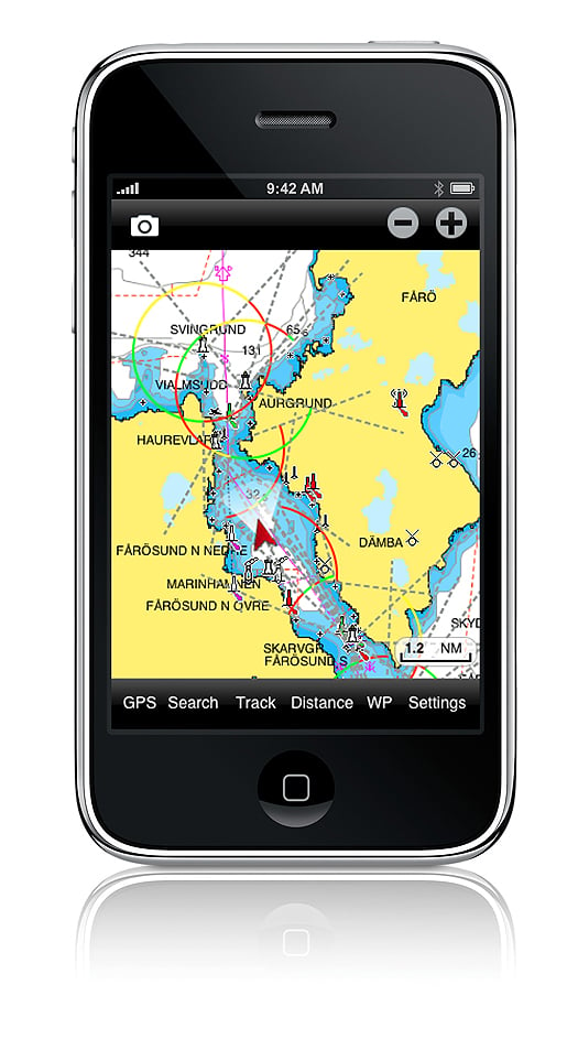
With the Navionics navigation package on your IPhone, I love the way that you can just tap on a port or marina and up will come the telephone number. One more tap on the screen and the phone is ringing.

GPS Reception

GPS is the key to position fixing and the IPhone has a built in receiver that should know where you are all the time. However, you will notice that your conventional chart plotter has its GPS antenna located outside the boat to ensure continuous reception. Your IPhone GPS will have its antenna inside the boat most of the time so you will need to check whether the GPS is working here. It may work under the windscreen and it should certainly work in an open boat or on the flybridge but GPS reception is certainly something to check out before you commit yourself to IPhone navigation. I use the Pocket GPS World App because this shows you the reliability of the position information being produced by the GPS and you should consider this vital information.

There are very cheap or free GPS Apps that you can download that will show your position, speed course etc, which you could use in conjunction with paper charts if you just want to simplify your IPhone navigation.

Navigation

There is no doubt in my mind that that the Navionics App is the best one both for route planning and for navigation itself. This system has rave reviews and it works extremely well by offering most of the facilities that are found on mainstream chart plotters on the small screen of the IPhone. There is virtually worldwide chart coverage and you simply download the App that is relevant to the area you plan to sail in. For instance you can get chart coverage of the whole of the UK and Northern Europe for the price of a couple of bottles of wine.

It is the compact size of the screen that can make things difficult but you soon get used to this. When you are plotting a route, you need to take extra care that the route you have chosen is free from dangers and this can only be done by expanding the scale and then carefully studying the route in detail. I found it too easy to set the waypoints out and then find that the chosen route passes over a rock or a shoal that does not show up too well on the small screen or the scale that you are using.

You set the waypoints by selecting WP and then simply tapping the screen and with big fingers, it is not easy to set them accurately. However, they are easy to adjust, again by simply touching the way point and dragging it to where you want it to be. It took me 5 minutes to plot a route involving 10 waypoints and that including checking it out afterwards.

Once plotted all you need to do is keep the 'own ship' icon on the course line to follow the route. You can set the track plotting mode so that you have a record of where you have been and you get a heading vector and a speed read-out provided that you are doing more than 5 knots. That might be a handicap for sail boats because that heading vector is particularly useful to see where you are going in relation to the plotted route.

Don't take for granted that the GPS plot is giving accurate information. As mentioned above, I like to get a check on the quality of the GPS fix because when I was testing the IPhone, there were a couple of times when it plotted over the land and I was confident that I was on the water.

The Navionics App also has tidal and current information for 7 days ahead for a variety of locations around your position. There is so much information built into the system that you have virtually everything at your fingertips. However, there are some things that it will not do such as showing you the total distance of a route you have plotted and the courses and distances of each leg of the route. That said, the Navionics App has to be one of the most useful for those who want to navigate on the water.

AIS

You cannot get a direct read-out from the AIS transmitters around you because you need VHF for that but the next best thing is the Ship Finder App. With this App you can go to nearly any location around the world and it will show you the ships and boats that are transmitting their AIS signals. Tap on any one of the ship icons and it will show you all the details of the ship including its size, destination and course and speed. This function is more of interest than a serious navigation tool but it could be useful to indentify a ship out at sea and to give some idea of where it might be heading.

Compass

The IPhone has a built-in compass but there are also a number of Apps available with alternative compass displays. The standard display shows both an analogue and a digital read-out of the heading and checking this out at sea, it seems to be reasonably accurate, say to within 5°. The reason it is hard to get better accuracy is that the heading shown is the way that the IPhone is pointing and it is hard to get this lined up exactly with the bow of the boat. It only wants a slight movement of the phone to change the heading by several degrees. However as an emergency compass it works and you have the choice of the readout in either true or magnetic headings.

Weather

If your IPhone is connected to the Internet then you can access all the web sites that offer weather information. However I use an App called Weather Pro that will give you detailed 7 day weather at any port you programme in. The forecast is given for every 3 hours and details thing like wind strength and direction as well as predicted wind gust speeds. However, you do need to be aware that these are basically land forecasts and the conditions at sea could vary a little.

Comments

Every time that I have used the IPhone for navigation I have been amazed at its capabilities. It gives you so much information in such a small package that you will wonder how you ever managed without it. This really is the problem because in time you will take everything the IPhone can do for granted and you will no longer check that it is giving good quality navigation information. The biggest worry is the quality of the GPS position information because much of the navigation depends on this. I used the App that tells you the quality of the GPS fix but that means switching over to this at frequent intervals. It would be much better to have an automatic system that throws up an alarm when the GPS position is poor. I am sure that will come with time.

I would be nervous if the IPhone was my only source of navigation information. It is easily dropped, it is not waterproof and the battery has only a limited life. Of course, you can mount it into a holder and you can keep the charger plugged in to overcome the battery life problem and you can get extra life batteries. Where the IPhone scores is that it makes a great back-up system that will cover most of your navigation needs. In this respect, it could replace the hand held GPS and the hand- held VHF to a certain extent but before you throw these items away, I would suggest that you get a lot of experience with IPhone navigation. Only then will it become the true navigation friend that this remarkable piece of equipment is.

Published in Afloat Guide
Tagged under
Waterways Ireland is advising Shannon Navigation users that a vessel is presently sunk immediately downstream of the bridge at Shannonbridge and is a hazard to navigation.

It is intended to lift this vessel using a pontoon and lifting equipment on Thurs 30 Jun 2011, commencing at 08.00hrs. It is expected that the operation will take four hours. Masters should expect to be delayed when passing through the area.

All vessels passing the pontoons should exercise due caution and heed the advice and instructions of the safety boat in attendance.

Southbound vessels in particular should be aware of their speed as they approach the navigation arch with the attending flow in order to avoid a close quarters situation with the pontoon. Use of extra fenders in the bow area of vessels would be a prudent precautionary measure when passing the lifting rig.

Published in Inland Waterways
Minister for Transport, Tourism and Sport Mr. Leo Varadkar T.D. yesterday announced his intention to amalgamate Dundalk port with the capital port, writes Jehan Ashmore.
Minister Varadkar said: 'It is with great regret that I have come to the conclusion that the financial difficulties faced by Dundalk Port Company mean that it no longer has a future as an independent company'.

"In order to ensure the orderly management of the company's affairs, I have decided that the best course of action is to transfer responsibility for the port to Dublin Port Company. I would be hopeful that port activities will continue at Dundalk following the transfer.

He added, once the current difficulties are overcome, it may be the case that Dundalk Port can return to local control, in cooperation with the local authority and private sector operators.

To amalgamate the two port companies a Transfer Order will be made under the Harbours Act 1996. In addition a draft order has to be approved by both Houses of the Oireachtas before being signed into law which is expected to take place within the coming weeks.

The Co. Louth port which is equidistant between Dublin and Belfast, has shown to have a long history as an independent seaport. However the recession has had a significant impact making trading conditions particularly difficult for the company. At its peak in 2006 there were over 220 vessels calling at the port but dropped to just over 60 vessels last year. Figures for 2011 show no signs of improvement.

Vessels of up to 3,500 dwt and 106m in length can be handled at the port's six berths. Unusally for an Irish port vessels can be seen resting on the mudbank subject to the state of the tide. The port is some 8kms from the open sea and is reached along a narrow channel which requires the compulsory use of a pilot.

Published in Ports & Shipping
Masters and owners on inland waterways have been advised that the winter mooring period ends on Thurs 31 Mar 2011 thereafter Navigation Bye-law No. 17(3) applies i.e. Vessels should not be berthed in the same harbour for longer than the statutory period of five consecutive days or more than a total of 7 days in any one month.
Published in Inland Waterways
The Commissioners of Irish Lights has said it consulted widely about discontinuing the last remaining fog signals around Ireland's coastline, The Irish Times reports.

Nine lighthouses operated directly by the authority in the Republic and Northern Ireland, along with several others run by harbours or local authorities - including Cork Harbour and Dun Laoghaire - will sound their last fog signals tomorrow.

Capt Kieran O'Higgins of the Commissioners of Irish Lights said the plan was notified to mariners in September 2010, and was taken due to "advances in marine navigation technology".

However Capt Michael Coleman, formerly of the Jeanie Johnston, did not think the plan was adequately publicised. He also noted now many smaller boats without advanced equipment that navigate by charts often reply on fog signals for safe passage.

Even bigger boats that navigate by GPS could be affected in dangerous situations if they suffer a power failure, he said.

On Afloat's official Facebook page, Cork resident Denis Cronin commented: "If this is the last night the [Cork Harbour] fog horn blows, it's a sad night.

"The tune she blows is a comfort for all those at sea and for all those at home for been home safely."

What do you think of the end of Ireland's fog signals? HAVE YOUR SAY on our facebook page HERE!

BBC Article HERE

Irish Times Article HERE

Published in Ilen
The Department of Transport today has issued a Marine Notice (No. 35, 2010) to advise that all Irish ships having radio communications or radio navigational equipment, which transmits radio signals, must hold a ship radio licence under the Wireless Telegraphy Acts. This is also a requirement under the International Radio Regulations of the International Telecommunications Union ITU.
The ITU Radio Regulation Article 47.2 specifically lays out the requirement for the operator of a ship to have a recognition or authorisation (Authority To Operate) issued by the administration issuing a ship radio licence, to a ship station. The applicable legislation in Ireland is the Wireless Telegraphy Act 1926; Wireless Telegraphy Act 1972; Communications Regulation Act 2002; and amending legislation, in particular the Wireless Telegraphy (Ship Station Radio Licence) Regulations 2006 (S.I. 414 of 2006)

In order to comply with these regulations, Ireland accepts the following documents as meeting the requirements on board its vessels:

To view the regulations in greater detail logon HERE

Published in Ports & Shipping
Page 3 of 3

Aquaculture Information

Aquaculture is the farming of animals in the water and has been practised for centuries, with the monks farming fish in the middle ages. More recently the technology has progressed and the aquaculture sector is now producing in the region of 50 thousand tonnes annually and provides a valuable food product as well as much needed employment in many rural areas of Ireland.

A typical fish farm involves keeping fish in pens in the water column, caring for them and supplying them with food so they grow to market size. Or for shellfish, containing them in a specialised unit and allowing them to feed on natural plants and materials in the water column until they reach harvestable size. While farming fish has a lower carbon and water footprint to those of land animals, and a very efficient food fed to weight gain ratio compared to beef, pork or chicken, farming does require protein food sources and produces organic waste which is released into the surrounding waters. Finding sustainable food sources, and reducing the environmental impacts are key challenges facing the sector as it continues to grow.

Salmon is the most popular fish bought by Irish families. In Ireland, most of our salmon is farmed, and along with mussels and oysters, are the main farmed species in the country.

Aquaculture in Ireland

  • Fish and shellfish are farmed in 14 Irish coastal counties.
  • Irish SMEs and families grow salmon, oysters, mussels and other seafood
  • The sector is worth €150m at the farm gate – 80% in export earnings.
  • The industry sustains 1,833 direct jobs in remote rural areas – 80% in the west of Ireland
  • Every full-time job in aquaculture creates 2.27 other jobs locally (Teagasc 2015)
  • Ireland’s marine farms occupy 0.0004% of Ireland’s 17,500Km2 inshore area.
  • 83% of people in coastal areas support the development of fish farming
  • Aquaculture is a strong, sustainable and popular strategic asset for development and job creation (Foodwise 2025, National Strategic Plan, Seafood
  • Operational Programme 2020, FAO, European Commission, European Investment Bank, Harvesting Our Ocean Wealth, Silicon Republic, CEDRA)
    Ireland has led the world in organically certified farmed fish for over 30 years
  • Fish farm workers include people who have spent over two decades in the business to school-leavers intent on becoming third-generation farmers on their family sites.

Irish Aquaculture FAQs

Aquaculture, also known as aquafarming, is the farming of aquatic organisms such as fish, crustaceans, molluscs and aquatic plants, and involves cultivating freshwater and saltwater populations under controlled conditions- in contrast to commercial fishing, which is the harvesting of wild fish. Mariculture refers to aquaculture practiced in marine environments and in underwater habitats. Particular kinds of aquaculture include fish farming, shrimp farming, oyster farming, mariculture, algaculture (such as seaweed farming), and the cultivation of ornamental fish. Particular methods include aquaponics and integrated multi-trophic aquaculture, both of which integrate fish farming and plant farming.

About 580 aquatic species are currently farmed all over the world, according to the UN Food and Agriculture Organisation (FAO), which says it is "practised by both some of the poorest farmers in developing countries and by multinational companies".

Increasing global demand for protein through seafood is driving increasing demand for aquaculture, particularly given the pressures on certain commercially caught wild stocks of fish. The FAO says that "eating fish is part of the cultural tradition of many people and in terms of health benefits, it has an excellent nutritional profile, and "is a good source of protein, fatty acids, vitamins, minerals and essential micronutrients".

Aquaculture now accounts for 50 per cent of the world's fish consumed for food, and is the fastest-growing good sector.

China provides over 60 per cent of the world's farmed fish. In Europe, Norway and Scotland are leading producers of finfish, principally farmed salmon.

For farmed salmon, the feed conversion ratio, which is the measurement of how much feed it takes to produce the protein, is 1.1, as in one pound of feed producing one pound of protein, compared to rates of between 2.2 and 10 for beef, pork and chicken. However, scientists have also pointed out that certain farmed fish and shrimp requiring higher levels of protein and calories in feed compared to chickens, pigs, and cattle.

Tilapia farming which originated in the Middle East and Africa has now become the most profitable business in most countries. Tilapia has become the second most popular seafood after crab, due to which its farming is flourishing. It has entered the list of best selling species like shrimp and salmon.

There are 278 aquaculture production units in Ireland, according to Bord Iascaigh Mhara (BIM) *, producing 38,000 tonnes of finfish and shellfish in 2019 and with a total value of €172 million

There are currently almost 2,000 people directly employed in Irish aquaculture in the Republic, according to BIM.

BIM figures for 2019 recorded farmed salmon at almost 12,000 tonnes, valued at €110 million; rock oysters reached 10,300 tonnes at a value of €44 million; rope mussels at 10,600 tonnes were valued at €7 million; seabed cultured mussels at 4,600 tonnes were valued at €7 million; "other" finfish reached 600 tonnes, valued at €2 million and "other" shellfish reached 300 tonnes, valued at €2 million

Irish aquaculture products are exported to Europe, US and Asia, with salmon exported to France, Germany, Belgium and the US. Oysters are exported to France, with developing sales to markets in Hong Kong and China. France is Ireland's largest export for mussels, while there have been increased sales in the domestic and British markets.

The value of the Irish farmed finfish sector fell by five per cent in volume and seven per cent in value in 2019, mainly due to a fall on salmon production, but this was partially offset by a seven per cent increased in farmed shellfish to a value of 60 million euro. Delays in issuing State licenses have hampered further growth of the sector, according to industry representatives.

Fish and shellfish farmers must be licensed, and must comply with regulations and inspections conducted by the Sea Fisheries Protection Authority and the Marine Institute. Food labelling is a function of the Food Safety Authority of Ireland. There is a long backlog of license approvals in the finfish sector, while the Department of Agriculture, Food and Marine says it is working to reduce the backlog in the shellfish sector.

The department says it is working through the backlog, but notes that an application for a marine finfish aquaculture licence must be accompanied by either an Environmental Impact Statement (EIS) or an Environmental Impact Assessment Report (EIAR). As of October 2020, over two-thirds of applications on hand had an EIS outstanding, it said.

The EU requires member states to have marine spatial plans by 2021, and Ireland has assigned responsibility to the Department of Housing, Planning and Local Government for the National Marine Planning Framework (NMPF). Legislation has been drawn up to underpin this, and to provide a "one stop shop" for marine planning, ranging from fish farms to offshore energy – as in Marine Planning and Development Management Bill. However, the Department of Agriculture, Food and Marine confirmed last year that it intends to retain responsibility for aquaculture and sea-fisheries related development – meaning fish and shellfish farmers won't be able to avail of the "one stop shop" for marine planning.

Fish and shellfish health is a challenge, with naturally occurring blooms, jellyfish and the risk of disease. There are also issues with a perception that the sector causes environmental problems.

The industry has been on a steep learning curve, particularly in finfish farming, since it was hailed as a new future for Irish coastal communities from the 1970s – with the State's Electricity Supply Board being an early pioneer, and tobacco company Carrolls also becoming involved for a time. Nutrient build up, which occurs when there is a high density of fish in one area, waste production and its impact on depleting oxygen in water, creating algal blooms and "dead zones", and farmers' use of antibiotics to prevent disease have all been concerns, and anglers have also been worried about the impact of escaped farmed salmon on wild fish populations. Sea lice from salmon farmers were also blamed for declines in sea trout and wild salmon in Irish estuaries and rivers.

BIM says over 95% of all salmon farmed in Ireland are certified organic. Organically grown salmon are only fed a diet of sustainable organic feed. They are also raised in more spacious pens than traditional farmed salmon. The need to site locations for fish farms further out to sea, using more robust cages for weather, has been recognised by regulatory agencies. There is a move towards land-based aquaculture in Norway to reduce impact on local ecosystems. The industry says that antibiotic use is declining, and it says that "safe and effective vaccinations have since been developed for farmed fish and are now widely used". Many countries are now adopting a more sustainable approach to removing sea lice from salmon, using feeder fish such as wrasse and lumpsucker fish. Ireland's first lumpsucker hatchery was opened in 2015.

BIM says over 95% of all salmon farmed in Ireland are certified organic. Organically grown salmon are only fed a diet of sustainable organic feed. They are also raised in more spacious pens than traditional farmed salmon. The need to site locations for fish farms further out to sea, using more robust cages for weather, has been recognised by regulatory agencies. There is a move towards land-based aquaculture in Norway to reduce impact on local ecosystems. The industry says that antibiotic use is declining, and it says that "safe and effective vaccinations have since been developed for farmed fish and are now widely used". Many countries are now adopting a more sustainable approach to removing sea lice from salmon, using feeder fish such as wrasse and lumpsucker fish. Ireland's first lumpsucker hatchery was opened in 2015.

Yes, as it is considered to have better potential for controlling environmental impacts, but it is expensive. As of October 2020, the department was handling over 20 land-based aquaculture applications.

The Irish Farmers' Association has represented fish and shellfish farmers for many years, with its chief executive Richie Flynn, who died in 2018, tirelessly championing the sector. His successor, Teresa Morrissey, is an equally forceful advocate, having worked previously in the Marine Institute in providing regulatory advice on fish health matters, scientific research on emerging aquatic diseases and management of the National Reference Laboratory for crustacean diseases.

BIM provides training in the national vocational certificate in aquaculture at its National Fisheries College, Castletownbere, Co Cork. It also trains divers to work in the industry. The Institute of Technology Carlow has also developed a higher diploma in aqua business at its campus in Wexford, in collaboration with BIM and IFA Aquaculture, the representative association for fish and shellfish farming.

© Afloat 2020

At A Glance - Irish Aquaculture

  • Fish and shellfish are farmed in 14 Irish coastal counties
  • Salmon is the most popular fish bought by Irish families. 
  • In Ireland, most of our salmon is farmed, and along with mussels and oysters, are the main farmed species in the country.
  • The industry sustains 1,833 direct jobs in remote rural areas – 80% in the west of Ireland
  • Every full-time job in aquaculture creates 2.27 other jobs locally (Teagasc 2015)
  • Ireland’s marine farms occupy 0.0004% of Ireland’s 17,500Km2 inshore area.
  • 83% of people in coastal areas support the development of fish farming

Featured Sailing School

INSS sidebutton

Featured Clubs

dbsc mainbutton
Howth Yacht Club
Kinsale Yacht Club
National Yacht Club
Royal Cork Yacht Club
Royal Irish Yacht club
Royal Saint George Yacht Club

Featured Brokers

leinster sidebutton

Featured Webcams

Featured Associations

ISA sidebutton
ICRA
isora sidebutton

Featured Marinas

dlmarina sidebutton

Featured Chandleries

CHMarine Afloat logo
https://afloat.ie/resources/marine-industry-news/viking-marine

Featured Sailmakers

northsails sidebutton
uksails sidebutton
watson sidebutton

Featured Blogs

W M Nixon - Sailing on Saturday
podcast sidebutton
BSB sidebutton
wavelengths sidebutton
 

Please show your support for Afloat by donating