Menu

Ireland's sailing, boating & maritime magazine

Displaying items by tag: oil and gas exploration

The Minister for the Environment, Climate and Communications, Eamon Ryan TD, has obtained Cabinet approval to introduce legislation to ban licences for new oil and natural gas exploration. The legislation will be included in the Climate Action and Low Carbon Amendment Bill which will go before the Oireachtas shortly.

Today’s decision will ensure legislative effect is given to the commitment in the Programme for Government to end the issuing of new licences for the exploration and extraction of gas, on the same basis as the 2019 decision in relation to oil exploration and extraction. The Minister gave effect to this commitment immediately; the Department no longer accepts new applications for exploration licences for natural gas or oil, nor will there be any future licensing rounds. The legislation will involve amendments to the Petroleum and Other Minerals Development Act 1960, which is the legislation governing the issuing of petroleum authorisations in the Irish offshore.

Minister Ryan commented: “The decision we have made today to legislate for a ban on new oil exploration and extraction will send a powerful message, within Ireland and internationally, that Ireland is moving away from fossil fuels towards a renewable future. By keeping fossil fuels in the ground, we will incentivise the transition to renewable energy and put ourselves on a pathway to net zero by 2050. The previously announced prohibition on exploration for oil has had a welcome impact in terms of the numbers of existing authorisations that have been relinquished. I expect this number to reduce further in the period ahead given the increasingly challenging global investment environment for fossil fuels.”

The legislative amendments will not affect existing authorisations, with applications for authorisations and activities remaining subject to technical, financial and environmental assessments as appropriate.

Published in Power From the Sea

#CorkHarbour – The increasing strategic importance of Cork Harbour as a base for the oil and gas energy sector in the search for natural resources particularly off our southern shores, is evident with this recent view taken by our colleagues of the platform supply vessel (PSV) Bourbon Clear passing Cobh, writes Jehan Ashmore.

Not only is Bourbon Clear painted with a distinctive green hull but also features an unconventional bow which is of the X-BOW design, a unique and environmentally-friendly hull line design that is patented by her Norwegian developers Ulstein.

The odd looking X-Bow has an inverted bow design which was first introduced in 2005 with the Bourbon Orca, her introduction caused quite a splash in the offshore maritime world and beyond.

Since then, more 60 vessels of various designs have been completed with the specialist bow form which claims to improve handling in rough seas and in reduced levels of fuel consumption.

The 4,000 tonnes newbuild has further Nordic connections as the owners are Bourbon Offshore Norway. The company have a fleet of vessels that utilizise in the very latest design and technology so to provide supplies to oil and oil-related companies all over the world.

Bourbon clear x Bow Cork Harbour

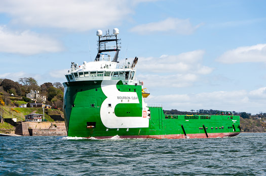
Bourbon Clear passes Port Control at 'The Holy Ground' area of Cork Harbour. Photo: Bob Bateman

Currently Bourbon have newbuilds under construction and they are of the Ulstein PX105 PSV design in which the 80m Bourbon Clear belongs to this series having been launched last year from a Chinese shipyard.

Bourbon Clear has called previously to Cobh Cruise Terminal and in the background of the (TOP) photo, is yet another Norwegian flagged vessel, Hurtigruten's Fram, the polar expedition cruiseship which visited Dublin Port yesterday.
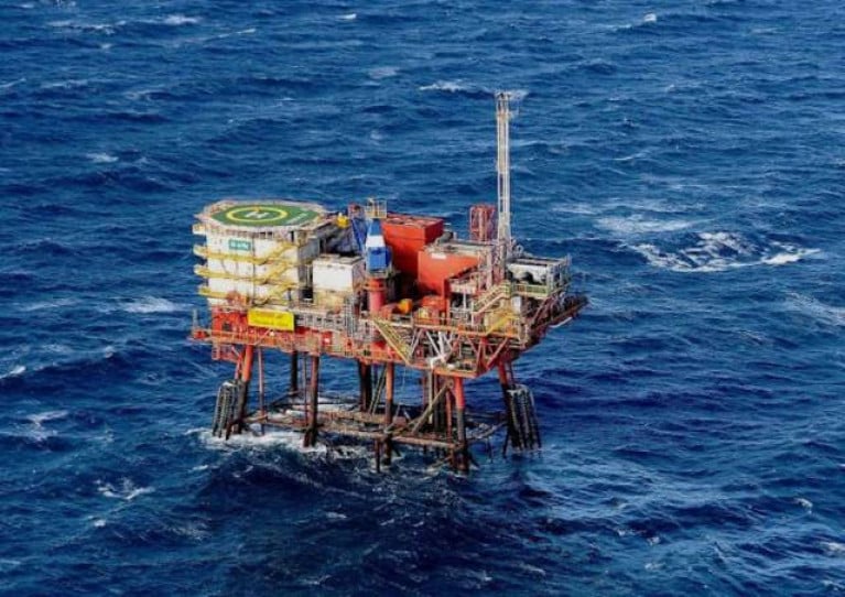
 

Published in Cork Harbour

#COASTAL NOTES - Providence Resources has struck big off the south coast of Cork with an oil flow that could be worth billions of euro to the beleaguered Irish economy.

According to the Guardian, the Dublin-based company announced yesterday that oil had started to flow successfully from its Barryroe structure in the north Celtic Sea at nearly twice the rate previously projected.

Providence Resources CEO Tony O'Reilly Jr said the discovery was a "seminal day for Ireland, especially in the runup to St Patrick's Day."

Last month the firm had confirmed the presence of light oil with its first appraisal well at the site, a situation described by its technical director as "extremely encouraging".

Now that a steady flow has been achieved, future extraction from the oil field - comparable to a medium-to-large North Sea field - can surely proceed, which now puts pressure on the Government to grand permission for further exploration around the Irish coast.

As previously reported on Afloat.ie, plans by Providence Rescources to prospect for oil on the east coast off Dalkey Island have been met with fierce opposition by mainland residents and environmental groups.

The Guardian has much more on the story HERE.

Published in Coastal Notes

Ireland's offshore islands

Around 30 of Ireland's offshore islands are inhabited and hold a wealth of cultural heritage.

A central Government objective is to ensure that sustainable vibrant communities continue to live on the islands.

Irish offshore islands FAQs

Technically, it is Ireland itself, as the third largest island in Europe.

Ireland is surrounded by approximately 80 islands of significant size, of which only about 20 are inhabited.

Achill island is the largest of the Irish isles with a coastline of almost 80 miles and has a population of 2,569.

The smallest inhabited offshore island is Inishfree, off Donegal.

The total voting population in the Republic's inhabited islands is just over 2,600 people, according to the Department of Housing.

Starting with west Cork, and giving voting register numbers as of 2020, here you go - Bere island (177), Cape Clear island (131),Dursey island (6), Hare island (29), Whiddy island (26), Long island, Schull (16), Sherkin island (95). The Galway islands are Inis Mór (675), Inis Meáin (148), Inis Oírr (210), Inishbofin (183). The Donegal islands are Arranmore (513), Gola (30), Inishboffin (63), Inishfree (4), Tory (140). The Mayo islands, apart from Achill which is connected by a bridge, are Clare island (116), Inishbiggle (25) and Inishturk (52).

No, the Gaeltacht islands are the Donegal islands, three of the four Galway islands (Inishbofin, like Clifden, is English-speaking primarily), and Cape Clear or Oileán Chléire in west Cork.

Lack of a pier was one of the main factors in the evacuation of a number of islands, the best known being the Blasket islands off Kerry, which were evacuated in November 1953. There are now three cottages available to rent on the Great Blasket island.

In the early 20th century, scholars visited the Great Blasket to learn Irish and to collect folklore and they encouraged the islanders to record their life stories in their native tongue. The three best known island books are An tOileánach (The Islandman) by Tomás Ó Criomhthain, Peig by Peig Sayers, and Fiche Blian ag Fás (Twenty Years A-Growing) by Muiris Ó Súilleabháin. Former taoiseach Charles J Haughey also kept a residence on his island, Inishvickillaune, which is one of the smaller and less accessible Blasket islands.

Charles J Haughey, as above, or late Beatle musician, John Lennon. Lennon bought Dorinish island in Clew Bay, south Mayo, in 1967 for a reported £1,700 sterling. Vendor was Westport Harbour Board which had used it for marine pilots. Lennon reportedly planned to spend his retirement there, and The Guardian newspaper quoted local estate agent Andrew Crowley as saying he was "besotted with the place by all accounts". He did lodge a planning application for a house, but never built on the 19 acres. He offered it to Sid Rawle, founder of the Digger Action Movement and known as the "King of the Hippies". Rawle and 30 others lived there until 1972 when their tents were burned by an oil lamp. Lennon and Yoko Ono visited it once more before his death in 1980. Ono sold the island for £30,000 in 1984, and it is widely reported that she donated the proceeds of the sale to an Irish orphanage


Yes, Rathlin island, off Co Antrim's Causeway Coast, is Ireland's most northerly inhabited island. As a special area of conservation, it is home to tens of thousands of sea birds, including puffins, kittiwakes, razorbills and guillemots. It is known for its Rathlin golden hare. It is almost famous for the fact that Robert the Bruce, King of Scots, retreated after being defeated by the English at Perth and hid in a sea cave where he was so inspired by a spider's tenacity that he returned to defeat his enemy.

No. The Aran islands have a regular ferry and plane service, with ferries from Ros-a-Mhíl, south Connemara all year round and from Doolin, Co Clare in the tourist season. The plane service flies from Indreabhán to all three islands. Inishbofin is connected by ferry from Cleggan, Co Galway, while Clare island and Inishturk are connected from Roonagh pier, outside Louisburgh. The Donegal islands of Arranmore and Tory island also have ferry services, as has Bere island, Cape Clear and Sherkin off Cork. How are the island transport services financed? The Government subsidises transport services to and from the islands. The Irish Coast Guard carries out medical evacuations, as to the RNLI lifeboats. Former Fianna Fáíl minister Éamon Ó Cuív is widely credited with improving transport services to and from offshore islands, earning his department the nickname "Craggy island".

Craggy Island is an bleak, isolated community located of the west coast, inhabited by Irish, a Chinese community and one Maori. Three priests and housekeeper Mrs Doyle live in a parochial house There is a pub, a very small golf course, a McDonald's fast food restaurant and a Chinatown... Actually, that is all fiction. Craggy island is a figment of the imagination of the Father Ted series writers Graham Linehan and Arthur Mathews, for the highly successful Channel 4 television series, and the Georgian style parochial house on the "island" is actually Glenquin House in Co Clare.

Yes, that is of the Plassey, a freighter which was washed up on Inis Oírr in bad weather in 1960.

There are some small privately owned islands,and islands like Inishlyre in Co Mayo with only a small number of residents providing their own transport. Several Connemara islands such as Turbot and Inishturk South have a growing summer population, with some residents extending their stay during Covid-19. Turbot island off Eyrephort is one such example – the island, which was first spotted by Alcock and Brown as they approached Ireland during their epic transatlantic flight in 1919, was evacuated in 1978, four years after three of its fishermen drowned on the way home from watching an All Ireland final in Clifden. However, it is slowly being repopulated

Responsibility for the islands was taking over by the Department of Rural and Community Development . It was previously with the Gaeltacht section in the Department of Media, Tourism, Arts, Culture, Sport and the Gaeltacht.

It is a periodic bone of contention, as Ireland does not have the same approach to its islands as Norway, which believes in right of access. However, many improvements were made during Fianna Fáíl Galway West TD Éamon Ó Cuív's time as minister. The Irish Island Federation, Comdháil Oileáin na hÉireann, represents island issues at national and international level.

The 12 offshore islands with registered voters have long argued that having to cast their vote early puts them at a disadvantage – especially as improved transport links mean that ballot boxes can be transported to the mainland in most weather conditions, bar the winter months. Legislation allowing them to vote on the same day as the rest of the State wasn't passed in time for the February 2020 general election.

Yes, but check tide tables ! Omey island off north Connemara is accessible at low tide and also runs a summer race meeting on the strand. In Sligo, 14 pillars mark the way to Coney island – one of several islands bearing this name off the Irish coast.

Cape Clear or Oileán Chléire is the country's most southerly inhabited island, eight miles off the west Cork coast, and within sight of the Fastnet Rock lighthouse, also known as the "teardrop of Ireland".
Skellig Michael off the Kerry coast, which has a monastic site dating from the 6th century. It is accessible by boat – prebooking essential – from Portmagee, Co Kerry. However, due to Covid-19 restrictions, it was not open to visitors in 2020.
All islands have bird life, but puffins and gannets and kittiwakes are synonymous with Skellig Michael and Little Skellig. Rathlin island off Antrim and Cape Clear off west Cork have bird observatories. The Saltee islands off the Wexford coast are privately owned by the O'Neill family, but day visitors are permitted access to the Great Saltee during certain hours. The Saltees have gannets, gulls, puffins and Manx shearwaters.
Vikings used Dublin as a European slaving capital, and one of their bases was on Dalkey island, which can be viewed from Killiney's Vico road. Boat trips available from Coliemore harbour in Dalkey. Birdwatch Ireland has set up nestboxes here for roseate terns. Keep an eye out also for feral goats.
Plenty! There are regular boat trips in summer to Inchagoill island on Lough Corrib, while the best known Irish inshore island might be the lake isle of Innisfree on Sligo's Lough Gill, immortalised by WB Yeats in his poem of the same name. Roscommon's Lough Key has several islands, the most prominent being the privately-owned Castle Island. Trinity island is more accessible to the public - it was once occupied by Cistercian monks from Boyle Abbey.

©Afloat 2020