Menu

Ireland's sailing, boating & maritime magazine

Inland afloat headers


Displaying items by tag: Dun Laoghaire Harbour News

# FASHION –In addition to this evening's fashion show in aid of the development fund for the Maritime Institute of Ireland's maritime museum in Dun Laoghaire, as previously reported on Afloat.ie, a maritime morning of free lectures will be presented in Dublin City Library on Saturday, writes Jehan Ashmore.
The Old Dublin Society, in partnership with Dublin City Library and Archive, will present the lectures in the Conference Room of the Dublin City Library and Archive located on 138 – 144 Pearse Street, Dublin 2. The times of the three lecture topics are listed below:

10 a.m. 'Dublin Port – Past and Present'– Niall Dardis

11 a.m. 'The Blood Red Badge: Dublin Dockers, Seamen and their Unionisation' – Francis Devine

12 Noon 'Liffey Ships' – Pat Sweeney

All are welcome to attend the lecture morning, noting the nearest DART station to the venue is at Pearse Street. For further information about other events, activities and developments of the M.I.I. visit www.mariner.ie

Published in Boating Fixtures
#MARITIME MUSEUM – Independent T.D.'s Richard Boyd Barrett, Luke'Ming' Flanagan and Mick Wallace are to don 'conservative' attire, albeit briefly!..wearing collars, ties and suits for a 'Fashion Show Extavaganza' to aid the re-opening of the National Maritime Museum in Dun Laoghaire, writes Jehan Ashmore.
In addition to the appearance of the public representatives, local fashion from Dun Laoghaire, Glasthule and Monkstown will be modelled by professional models. There will also be Captain Roger's Treasure Raffle with great prizes and big surprizes.

The fundraiser event which is in aid of the Development Fund of the museum, is to take place this Thursday evening (8 p.m.) on 10th November, in the National Yacht Club (NYC) along the waterfront of Dun Laoghaire Harbour, close to the East Pier.

Tickets costing €20 are available from the Maritime Institute of Ireland's (M.I.I.) museum office located on the top floor of the Dun Laoghaire Shopping Centre, in local fashion shops and by contacting (01) 214 3964.

At the end of last month, the M.I.I. celebrated its 70th anniversary which was founded in 1941. To read more about the museum which is undergoing renovation and due to re-open in March 2012 click HERE and to read other news and developments visit www.mariner.ie

Published in Boating Fixtures
Irish Sea fast-ferry Stena Lynx III (1996/4,113grt) which has been laid-up in Dun Laoghaire Harbour since last month has been sold to interests in South Korea. Renamed Sunflower 2 and flying the flag of the Far-Eastern nation, she departed yesterday afternoon on a delivery voyage expected to take around twenty-five days, writes Jehan Ashmore.
The Dublin Port pilot cutter Camac was in attendance as the 650 passenger/153 vehicle fast-ferry departed at 16.20hrs. She is re-registered in Busan, South Korea's second largest city, located in the south-east, where she is to operate to the island of Jeju off the country's south-west coast.

Sunflower 2 is to make bunker calls on the repositioning voyage, firstly in Valletta, Malta before she transits the Suez Canal to the Red Sea port of Jeddah, Saudi Arabia and Columbo, Sri Lanka. From there she transits the Strait of Malacca then through the South China Sea followed by the East China Sea before finally entering the Strait of Korea to her homeport of Busan.

Since 1999 she has served Stena Line's fast-ferry high-season Rosslare-Fishguard route sailings taking 1 hour 50 minutes in tandem with conventional ferry Stena Europe (1981/24,828grt) which currently maintains the year-round 3 hours 30 minutes route. It is believed that Stena Line will not be operating high-season fast-ferry services in 2012.

Prior to her Dun Laoghaire departure, her South Korean crew have been preparing the craft over the last three weeks. Notably there was the removal of all Stena Line corporate livery markings on the hull. Her new name and port of registry were painted at the stern though she retained her original name at the bow which included both symbols of an Irish shamrock aptly to starboard (green) and the Welsh dragon to port (red) to reflect her Irish Sea southern corridor route.

Stena Lynx III departing Dun Laoghaire last year, note her starboard 'Shamrock' at the bow.

In recent years on the St. Georges Channel route she was marketed as the Stena 'Express'. Her final sailing this year was 4 September and three days later she docked Dun Laoghaire at St. Michaels Pier. On the adjacent berth which is designed specifically for and only capable of accommodating the HSS 1500 class fast-ferries.

Stena Lynx III also ran several shoulder season stints on the Dun Laoghaire-Holyhead route with the HSS Stena Explorer (1996/19,638grt) only running during the busier summer months. During this summer all sailings were maintained by HSS Stena Explorer until the route became a seasonal-only service for the first time this year when the last sailing took place in mid-September. The HSS remains in layover for the winter in Holyhead at her dedicated berth. The route is due to re-open in April or May.

The 35 knot Stena Lynx III was launched from fast-ferry catamaran specialists InCAT Pty based in the Tasmanian capital of Hobart. Early in her career the 81m wave-piercing catamaran (WPC) craft served Dover-Calais followed by two seasons between Newhaven-Dieppe when renamed P&O Elite for joint operators P&O Stena Line.

Her predecessors the WPC InCat 74m Stena Sea Lynx, became the first car-carrying catamaran to operate Dun Laoghaire-Holyhead sailings in 1993. The pioneering water-jet propelled craft was replaced in subsequent years by the larger InCAT 78m Stena Lynx II.

She was replaced in 1996 when the revolutionary four gas-turbine engine water-jet propelled HSS Stena Explorer was introduced. A further two sisters of the HSS 1500 class (High-speed Sea Service) were completed by Finnyards in Rauma.

Published in Ferry
The 'soft-opening' of the Maritime Institute of Ireland's (M.I.I.) maritime museum in Dun Laoghaire this Saturday is to showcase developments to invited groups. The public will be welcomed to the museum when it is due to officially opened in March 2012.
For several years the museum located close to Dun Laoghaire Harbour's East Pier has been undergoing extensive renovation in addition to display projects that are due for completion. In order for local groups to gain an understanding of what has been achieved to date, the soft-opening will provide a glimpse of what is to be expected with the official opening next year.

Following the one-day soft-opening, any group which wishes to visit the museum by appointment should contact the MII's Tel: (01) 280 0969 or you can also call (01) 214 3934.

To read more about the renovation programme click HERE. If you would like to assist through voluntary work, fund-raising activities or make a donation in addition to keeping abreast of news, events and winter lecture programme visit www.mariner.ie

Published in Dublin Bay
The 'soft' re-opening of the Maritime Institute of Ireland's (M.I.I.) renovated maritime museum in Dun Laoghaire is this Sunday, though the opening is dependent to fire officer's approval, writes Jehan Ashmore.
For several years the museum has been closed due to extensive renovation that was urgently required in the former Mariners Church built in 1837. In 1971 the church closed and the museum moved into the building in 1976. The church retains many of the original features, including the prisoner's docks in the gallery and magnificent stained glass windows. Externally the building has also undergone external renovation with extensive cleaning of the structure's stonework.
It is situated between the town's main shopping thoroughfare on Georges Street Upper and Dun Laoghaire Harbour's East Pier. If you are arriving to Dun Laoghaire by DART, why not take the short stroll to the museum along The 'Metals' as far as the Christ the King sculpture opposite the East Pier. From here there are steps that lead up to Haigh Terrace and the museum.

At the end of this month the M.I.I. will celebrate the 70th anniversary of its foundation and it is the intention of the voluntary run museum to 'officially' re-open in March 2012.

To read more about the renovation programme click HERE. If you would like to assist through voluntary work, fund-raising activities or make a donation in addition to keeping abreast of the latest developments visit www.mariner.ie


View Larger Map
Published in Dublin Bay
As part of this year's Open House Dublin event, the striking headquarters of the Commissioners of Irish Lights building in Dún Laoghaire Harbour will be open to the public tomorrow, writes Jehan Ashmore.
The iconic coastal landmark building built by Scott Tallon Walker Architects in 2008, consists of two-interconnected buildings that house offices and a marine depot. They utilise many eco-friendly and innovative technologies to ensure sustainable building design and energy efficiency.

Regular guided tours will provide a fascinating insight into the work of the Commissioners of Irish Lights (CIL). The tours (first-come basis) are also available for disabled access and they start from 12 noon to 5pm, noting the last tour is 4.30pm. Location: Harbour Road, Dún Laoghaire.

Like most of the tours and events in Open House Dublin, there is no pre-booking required. Entry is FREE and on a first-come basis. For more information about what to expect from your tour or event, check the How It Works by clicking HERE.

CIL operate the 79m aids-to-navigation tender ILV Granuaile which is based at her homeport of Dun Laoghaire. The 2,625grt tender was built by the Dutch Damen Shipyard group in Galati, Romania. She was then towed to The Netherlands where further outfitting work was conducted. She entered service in 2000 and she is the third tender to be named after the Mayo pirate queen.

Occasionally ILV Granuaile can be seen moored alongside the berth adjacant to the marine depot accessed through Dun Laoghaire Marina, though she mostly calls to the harbour's western bight area, using her DP (dynamic-positioning) mode. Her design is ideally suited for buoy and chain work, search and rescue, salvage and recovery, towing, hydrographic applications, and ROV work.

She is shallow drafted at 4.4m and has heavy lifting equipment including a 20 tonne aft-mounted crane with an outreach of 20m. Accommodation is for a crew of 16 in addition there are cabins for a further 10 persons.

Published in Lighthouses
On a rare occasion both the Marine Institute's research vessels docked in both Dublin Bay ports today, normally these vessels operate mostly off the western seaboard and using their home-port of Galway Harbour, writes Jehan Ashmore.
The 65m RV Celtic Explorer (2002 /2,425grt) made an early morning call to Dublin Port's Ocean Pier. Her smaller fleet-mate RV Celtic Voyager (1996/340grt) made a midday arrival to Dun Laoghaire Harbour's East Pier. She moored at the same berth last month, as previously reported on Afloat.ie The larger vessel has a greater range capability while the smaller vessel covers more inshore-work throughout the Irish coastline.

According to the vessels survey schedules, RV Celtic Explorer had today completed fisheries demersal surveys which started in Galway on 23 September. The near fortnight-long survey was conducted in the ICES area VI, under the direction of chief scientist, Dave Stokes.

On Friday she embarks on a herring acoustic survey which is to take place in the Celtic Sea and the south-west. This survey will be under chief scientist Ciaran O'Donnell and is to de-mobilise in Cork on 27 October. To read more about her 2011 survey programme click HERE.

Across Dublin Bay in neighbouring Dun Laoghaire, the 31m RV Celtic Voyager is currently nearing the end of a month-long hydrography survey of the Celtic Sea. The survey had started in Howth Harbour on 17 September under chief scientist Kevin Sheehan. For the time-being she remains moored in Dun Laoghaire prior to resuming survey work which will continue until the vessel de-mobilises in Rosslare in mid-October. To find out more about her remaining surveys for this year click HERE.

On the surveys outlined they are conducted on behalf of Marine Institute scientists, though the vessels are also allocated ship-time for use of third parties. These include government departments and agencies, universities, research institutes and industry. For further information on the research vessels, survey schedules etc can be found by visiting: www.marine.ie/home/Research+Vessels.htm


Published in Marine Science
As strollers take in the fresh conditions along Dun Laoghaire Harbour's East Pier today they will see the state's first purpose built oceanographic research vessel RV Celtic Voyager moored alongside at the jetty, writes Jehan Ashmore.
With her distinctive 31m green-painted hull, the 340 gross registerd tonnes (grt) vessel built by the Dutch Damen Shipyard in 1997, was commissioned for the Marine Institute, whose headquarters are based outside Galway city at Oranmore.

RV Celtic Voyager is an inshore RV and she can accommodate 6 - 8 scientists with a maximum endurance of 14 days. According to her intensive survey schedule she is currently conducting hydography work for this month entirely. To read her complete survey programme click HERE.

In 2002 she was joined by a second though considerably larger vessel the 65m RV Celtic Explorer, which is six times larger than her fleetmate in terms of tonnage, which is 2,425grt. Apart from all the scientific and deck machinery she can also handle seven 20-foot containerised laboratories.She has accommodates for 35 personnel, including 19-21 scientists and has an endurance window of 30 days.

The vessel was also built by the same Dutch shipyard and both are owned by the Marine Institute. Ship management of the Galway based pair is provided by P&O Maritime Services (Ireland) Ltd.

In addition the ROV Holland I a deepwater Remotely Operated Vehicle is operated on board the RV Celtic Explorer. The ROV is named after John Phillip Holland from Liscannor, Co. Clare who was an early inventor and builder of submarines. For more information about the ROV which forms as part of tonight's 'Sea2Sky' event in Salthill, Galway, as previously reported on Afloat.ie click HERE.

Today is European Researchers Night, where the ROV will be on display in Galway

Published in Marine Science
At 13.07hrs Stena Line's HSS 1500 fast-craft ferry HSS Stena Explorer pulled away from her berth for the last time this year on the Dun Laoghaire Harbour-Holyhead route, as she headed for the harbour mouth several crew members waved from the stern to shore-based colleagues on the link-span, writes Jehan Ashmore.
Only yesterday, sailings on the daily single-round trip operated route had to be cancelled due to adverse weather conditions on the Irish Sea caused by the tail end of Hurricane Katia. The decision with today's closure was made well in advance and comes as no surprise as the Stena Explorer (1996/19,638grt) "has traded at a financial loss for several years" according to her owners Stena Line. Around 53 staff in Dun Laoghaire will be affected by the decision.

The core reason to withdraw the HSS on the 120-minute route which is not to re-open until the 2012 season, rests with the high operating costs of the fuel-thirsty fast-ferry which is powered by four gas-turbine engines. In addition the route's generated most of its turnover during the period May-September, leaving the remaining months unsustainable, as such the company wants the route to be seasonal-only in the long-term.

HSS_Stena_Explorer

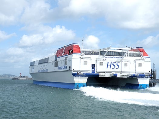
HSS Stena Explorer departs Dun Laoghaire Harbour on her final sailing this season. Photo: Jehan Ashmore

Passengers and freight customers will instead need to use the company's other Dublin Bay route between Dublin Port and Holyhead. The 3 hour 15-minute central corridor route is served by two ro-pax vessels, Stena Adventurer (2004/43,532 grt) and Stena Nordica (2000/24,206 grt) which operate to a year-round schedule, for times click HERE.

What is not certain is the precise date for resumption of Dun Laoghaire-Holyhead services as Stena Line have only indicated that they hope to reopen in April or May nor it is outlined as to what type of fast-craft would operate the route next year.

With today's break in service for at least the next six months, this is the most significant absence of the revolutionary HSS (High Speed Sea Service) 1500 fast-ferry which made her official maiden voyage on the route from Dun Laoghaire on 10th April 1996. The only other notable occasions when the HSS was off-service was for the short spells to allow for annual dry-docking, refit, repairs or when the route in recent years was partially operated by Stena Lynx III.

The 1500 referred to the number of passengers the Stena Explorer could accommodate. She was the first of the three Finish-built HSS 1500 catamaran vehicle capable carrying craft to enter service on three routes from the UK. The next sister completed HSS Stena Discovery entered service in the same year between Harwich-Hook van Holland and the final of the trio HSS Stena Voyager entered the Belfast-Stranraer route in 1997. Several years ago the HSS ceased operating on the Dutch route and the HSS currently serving on the North Channel is due to be replaced by conventional ferries in mid-November as previously reported on Afloat.ie, to read more click HERE.

On the Dun Laoghaire-Holyhead service the HSS enjoyed the boom years, and at its peak there were five daily round trips. From 2006 onwards the routes fortunes began to decline due to the ending of duty-free sales, competition from low-cost airlines, and the increasing cost of fuel.

In order to stave off further losses, a series of cost cutting measures were implemented over the next five years. Firstly the sailing frequency was reduced then the passage times were increased to reduce fuel consumption at the expense of faster crossings. In addition the company resorted to withdrawing the Stena Explorer during the shoulder months surrounding the summer and as previously mentioned these sailings were covered by the Stena Lynx III.

When the Stena Explorer returned for the summer months, the Stena Lynx III switched to her normal high-season spell on Rosslare-Fishguard sailings in tandem with regular route vessel Stena Europe. This year she served as usual on the St. Georges Channel route with the last high-season sailing completed on 4 September.

Stena Lynx III remained initially at Fishguard until making a repositioning voyage to Dun Laoghaire via the Kish Lighthouse last Wednesday. She berthed adjacent to the now disused HSS berth link-span on St. Michaels Wharf. The Tasmanian built craft has spent previous winter layover periods in Dublin and last year in Dun Laoghaire whereas the Stena Explorer is expected to do so in her home port of Holyhead.

At the neighbouring Carlisle Pier, the former terminal where numerous steam-packets, 'mailboats' and the conventional Sealink/British Rail car-ferries served (the last being the Stena Adventurer better known as St. Columba built in 1977) there are plans for a national diaspora museum.

The centrepiece landmark building would form as part of the masterplan proposed by the Dun Laoghaire Harbour Company as part of a concerted effort to offset the reduced role of ferry operations. The masterplan is also to attract cruiseship business amongst other proposals envisaged.

Published in Ferry
Following the successfull one-day maritime lecture seminar held last month in the Dun Loaghaire Club, an illustrated lecture on the Maritime Museum in Dun Laoghaire is to be held tomorrow at 8pm in the same venue. The presenter is Kevin Crothers, a former vice-president of the Maritime Institute of Ireland (M.I.I.).
The venue is situated off Marine Road behind St. Michaels Church and close to the Senior College Dun Laoghaire. All are welcome to attend the evening. To assist covering costs voluntary donations would be appreciated.

Kevin will be recounting his involvement with the acquisition of many of the museum's artefacts in addition to the part he has played in representing the M.I.I. on such issues as sail-training, and the National Monuments Legislation with relation to the Armada finds in Ireland. In addition, Kevin is an experienced yachtsman and he will be touching on that subject too during the evening.

The museum which is situated in the former Mariners Church, Haigh Terrace is due be re-opened with a 'preview' from 16 October 2011 to mark the M.I.I.'s 70th anniversary. The museum is due to be officially opened in Easter 2012. For more about the M.I.I., its museum and activities www.mariner.ie

Published in Boating Fixtures
Page 3 of 4

General Information on using Waterways Ireland inland navigations

Safety on the Water

All users of the navigations are strongly recommended to make themselves aware of safety on the water for whatever activity they are involved in and to read the advice offered by the various governing bodies and by:

The Dept. of Transport, Ireland: www.gov.ie/transport and The Maritime and Coastguard Agency, UK, The RNLI – Water Safety Ireland for information in terms of drowning prevention and water safety.

Registration of Vessels

All vessels using the Shannon Navigation, which includes the Shannon-Erne Waterways and the Erne System must be registered with Waterways Ireland. Only open undecked boats with an engine of 15 horsepower or less on the Shannon Navigation, and vessels of 10 horsepower or less on the Erne System, are exempt. Registration is free of charge.

Craft registration should be completed online at: https://www.waterwaysireland.org/online-services/craft-registration

Permits for use of the Grand and Royal Canals and the Barrow Navigation

All vessels using the Grand and Royal Canals and the Barrow Navigation must display appropriate valid Permit(s) i.e A Combined Mooring and Passage Permit (€126) and if not intending to move every five days, an Extended Mooring Permit (€152).

Permit applications should be completed online at: https://www.waterwaysireland.org/online-services/canal-permits

Passage on the Royal and Grand Canals – Dublin Area

For boat passage through the locks east of Lock 12 into / out of Dublin on either the Royal or Grand Canals, Masters are requested to contact the Waterways Ireland Eastern Regional Office (M-F 9.30am-4.30pm) on tel: +353(0)1 868 0148 or email [email protected] prior to making passage in order to plan the necessary lock-keeping assistance arrangements.

On the Grand Canal a minimum of two days notice prior to the planned passage should be given, masters should note that with the exception of pre-arranged events, a maximum of 2 boats per day will be taken through the locks, travelling either east or west.

Movements in or out of the city will be organised by prior arrangement to take place as a single movement in one day. Boaters will be facilitated to travel the system if their passage is considered to be safe by Waterways Ireland and they have the valid permit(s) for mooring and passage.

Newcomen Lifting Bridge

On the Royal Canal two weeks’ notice of bridge passage (Newcomen Lifting Bridge) is required for the pre-set lift date, and lock assistance will then also be arranged. A minimum of 2 boats is required for a bridge lift to go ahead.

Waterways Ireland Eastern Regional Office (Tel: +353(0)1 868 0148 or [email protected] ) is the point of contact for the bridge lift.

A maximum number of boats passing will be implemented to keep to the times given above for the planned lifts (16 for the Sat / Sun lifts & 8 for the weekday lifts). Priority will be given on a first come first served basis.

On day of lift, boaters and passengers must follow guidance from Waterways Ireland staff about sequence of passage under bridge & through Lock 1, and must remain within signed and designated areas.

Events Held on the Waterways

All organised events taking place on the waterways must have the prior approval of Waterways Ireland. This is a twelve week process and application forms must be accompanied with the appropriate insurance, signed indemnity and risk assessment. The application should be completed on the Waterways Ireland events page at :

https://www.waterwaysireland.org/online-services/event-approval

Time Limits on Mooring in Public Harbours

On the Shannon Navigation and the Shannon-Erne Waterway craft may berth in public harbours for five consecutive days or a total of seven days in any one month.

On the Erne System, revised Bye Laws state that: No master or owner shall permit a vessel, boat or any floating or sunken object to remain moored at or in the vicinity of any public mooring, including mooring at any other public mooring within 3 kilometres of that location, for more than 3 consecutive days and shall not moor at that same mooring or any other public mooring within 3 kilometres of that location within the following 3 consecutive days without prior permission by an authorised official.

Winter Mooring on the Shannon Navigation and Shannon Erne Waterway

Winter mooring may be availed of by owners during the period 1 Nov to 31 Mar by prior arrangement and payment of a charge of €63.50 per craft. Craft not availing of Winter Mooring must continue to comply with the “5 Day Rule”. Winter Mooring applications should be completed online at : https://www.waterwaysireland.org/online-services/winter-moorings-booking

Owners should be aware that electricity supply and water supply to public moorings is disconnected for the winter months. This is to protect against frost damage, to reduce running costs and to minimise maintenance requirements during the winter months.

Vessel owners are advised that advance purchasing of electricity on the power bollards leading up to the disconnection date should be minimal. Electricity credit existing on the bollards will not be recoverable after the winter decommissioning date. Both services will be reinstated prior to the commencement of the next boating season.

Smart Cards

Waterways Ireland smart cards are used to operate locks on the Shannon Erne Waterway, to access the service blocks, to use the pump-outs along the navigations, to avail of electrical power at Waterways Ireland jetties.

Berthing in Public Harbours

Masters are reminded of the following:

  • Equip their vessel with mooring lines of appropriate length and strength and only secure their craft to mooring bollards and cleats provided for this purpose.
  • Ensure the available berth is suitable to the length of your vessel, do not overhang the mooring especially on finger moorings on floating pontoon moorings.
  • Ensure mooring lines, electric cables and fresh water hoses do not create a trip hazard on public jetties for others users.
  • Carry sufficient fenders to prevent damage to your own vessel, other vessels and WI property.
  • Allow sufficient space between your vessel and the vessel ahead /astern (c.1m) for fire safety purposes and /or to recover somebody from the water.
  • Do not berth more than two vessels side by side and ensure there is safe access/egress at all times between vessels and onto the harbour itself.
  • Do not berth in such a way to prevent use of harbour safety ladders, slipways or pump-outs.
  • Do not allow the bow of your vessel to overhang the walkway of a floating mooring thus creating a hazard for others with an overhanging anchor or bow fendering.
  • Animals are not allowed to be loose or stray at any time.
  • Harbour and jetty infrastructure such as railings, power pedestals, fresh water taps, electric light poles, safety bollards, ladders etc are not designed for the purpose of mooring craft , they will not bear the strain of a vessel and will be damaged.
  • At Carrybridge on the Erne System, Masters of vessels are not permitted to use stern on mooring. Masters of vessels must use the mooring fingers for mooring of vessels and for embarkation / disembarkation from vessels.

Passenger Vessel Berths

Masters of vessels should not berth on passenger vessel berths where it is indicated that an arrival is imminent. Passenger vessels plying the navigations generally only occupy the berths to embark and disembark passengers and rarely remain on the berths for extended periods or overnight.

Lock Lead-in Jetties

Lead-in jetties adjacent to the upstream and downstream gates at lock chambers are solely for the purpose of craft waiting to use the lock and should not be used for long term berthing.

Vessel Wake

Vessel wake, that is, the wave generated by the passage of the boat through the water, can sometimes be large, powerful and destructive depending on the hull shape and engine power of the vessel. This wake can be detrimental to other users of the navigation when it strikes their craft or inundates the shoreline or riverbank. Masters are requested to frequently look behind and check the effect of their wake / wash particularly when passing moored vessels, on entering harbours and approaching jetties and to be aware of people pursuing other activities such as fishing on the riverbank.

Speed Restriction

A vessel or boat shall not be navigated on the Shannon Navigation at a speed in excess of 5 kph when within 200 metres of a bridge, quay, jetty or wharf, when in a harbour or canal or when passing within 100 metres of a moored vessel or boat.

Vessels navigating the Shannon-Erne Waterway should observe the general 5 kph speed limit which applies along the waterway. This is necessary in order to prevent damage to the banks caused by excessive wash from vessels.

Vessels navigating the Erne System should observe the statutory 5kt / 6mph / 10kph speed limit areas.

A craft on the Royal and Grand canals shall not be navigated at a speed in excess of 6km per hour.

A craft on the Barrow Navigation shall not be navigated at a speed in excess of 11km per hour except as necessary for safe navigation in conditions of fast flow.

Bank Erosion

Narrow sections of all the navigations are particularly prone to bank erosion due to the large wash generated by some craft. Masters are requested to be vigilant and to slow down to a speed sufficient to maintain steerage when they observe the wash of their craft inundating the river banks.

Unusual Waterborne Activity

Unusual waterborne vessels may be encountered from time to time, such as, hovercraft or amphibious aircraft / seaplanes. Masters of such craft are reminded to apply the normal “Rule of the Road” when they meet conventional craft on the water and to allow extra room to manoeuvre in the interest of safety.

Sailing Activity

Mariners will encounter large numbers of sailing dinghies from late June to August in the vicinity of Lough Derg, Lough Ree and Lower Lough Erne. Sailing courses are marked by yellow buoys to suit weather conditions on the day. Vessels should proceed at slow speed and with due caution and observe the rules of navigation when passing these fleets, as many of the participants are junior sailors under training.

Rowing

Mariners should expect to meet canoes and vessels under oars on any part of the navigations, but more so in the vicinity of Athlone, Carrick-on-Shannon, Coleraine, Enniskillen and Limerick. Masters are reminded to proceed at slow speed and especially to reduce their wash to a minimum when passing these craft as they can be easily upset and swamped due to their very low freeboard and always be prepared to give way in any given traffic situation.

Canoeing

Canoeing is an adventure sport and participants are strongly recommended to seek the advice of the sport’s governing bodies i.e Canoeing Ireland and the Canoe Association of Northern Ireland, before venturing onto the navigations.

Persons in charge of canoes are reminded of the inherent danger to these craft associated with operating close to weirs, sluice gates, locks and other infrastructure particularly when rivers are in flood and large volumes of water are moving through the navigations due to general flood conditions or very heavy localised precipitation e.g. turbulent and broken water, stopper waves. Shooting weirs is prohibited without prior permission of Waterways Ireland.

Canoeists should check with lockkeepers prior entering a lock to ensure passage is done in a safe manner. Portage is required at all unmanned locks.

Canoe Trail Network – "Blueways"

Masters of powered craft are reminded that a canoe trail network is being developed across all navigations and to expect more organised canoeing along these trails necessitating slow speed and minimum wash when encountering canoeists, rowing boats etc

Rockingham and Drummans Island Canals – Lough Key

It is expected that work on Rockingham and Drummans Island Canals on Lough Key will be completed in 2021. Access to these canals will be for non-powered craft only, eg canoes, kayaks, rowing boats.

Fast Powerboats and Personal Watercraft (Jet Skis)

Masters of Fast Powerboats (speed greater than 17kts) and Personal Watercraft (i.e.Jet Skis) are reminded of the inherent dangers associated with high speed on the water and especially in the confines of small bays and narrow sections of the navigations. Keeping a proper look-out, making early alterations to course and /or reducing speed will avoid conflict with slower vessels using the navigation. Personal Watercraft are not permitted to be used on the canals.

Towing Waterskiers, Wakeboarders, Doughnuts etc

Masters of vessels engaged in any of these activities are reminded of the manoeuvring constraints imposed upon their vessel by the tow and of the added responsibilities that they have to the person(s) being towed. These activities should be conducted in areas which are clear of conflicting traffic. It is highly recommended that a person additional to the master be carried to act as a “look-out” to keep the tow under observation at all times.

Prohibition on Swimming

Swimming in the navigable channel, particularly at bridges, is dangerous and is prohibited due to the risk of being run over by a vessel underway in the navigation.

Age Restrictions on operating of powered craft

In the Republic of Ireland, Statutory Instrument 921 of 2005 provides the legal requirements regarding the minimum age for operating of powered craft. The Statutory Instrument contains the following requirements:

- The master or owner of a personal watercraft or a fast power craft shall take all reasonable steps to ensure that a person who has not attained the age of 16 years does not operate or control the craft

- The master or owner of a pleasure craft powered by an engine with a rating of more than 5 horse power or 3.7 kilowatts shall take all reasonable steps to ensure that a person who has not attained the age of 12 years does not operate or control the craft.

Lifejackets and Personal Flotation Devices (PFDs)

Lifejackets and PFD’s are the single most important items of personal protective equipment to be used on a vessel and should be worn especially when the vessel is being manoeuvred such as entering / departing a lock, anchoring, coming alongside or departing a jetty or quayside.

In the Republic of Ireland, Statutory Instrument 921 of 2005 provides the legal requirements regarding the wearing of Personal Flotation Devices. The Statutory Instrument contains the following requirements:

- The master or owner of a pleasure craft (other than a personal watercraft) shall ensure, that there are, at all times on board the craft, sufficient suitable personal flotation devices for each person on board.

- A person on a pleasure craft (other than a personal watercraft) of less than 7 metres length overall shall wear a suitable personal flotation device while on board an open craft or while on the deck of decked craft, other than when the craft is made fast to the shore or at anchor.

- The master or owner of a pleasure craft (other than a personal watercraft) shall take all reasonable steps to ensure that a person who has not attained the age of 16 years complies with paragraph above.

- The master or owner of a pleasure craft (other than a personal watercraft), shall take all reasonable steps to ensure that a person who has not attained the age of 16 years wears a suitable personal flotation device while on board an open craft or while on the deck of a decked craft other than when it is made fast to the shore or at anchor.

- The master or owner of a pleasure craft (other than a personal watercraft) shall take all reasonable steps to ensure that a person wears a suitable personal flotation device, at all times while – (a) being towed by the craft, (b) on board a vessel or object of any kind which is being towed by the craft.

Further information is available at: http://www.irishstatutebook.ie/eli/2005/si/921/made/en/print

Firing Range Danger Area – Lough Ree

The attention of mariners is drawn to the Irish Defence Forces Firing Range situated in the vicinity of buoys No’s 2 and 3, on Lough Ree on the Shannon Navigation. This range is used regularly for live firing exercises, throughout the year, all boats and vessels should stay clear of the area marked with yellow buoys showing a yellow "X" topmark and displaying the word "Danger".

Shannon Navigation, Portumna Swing Bridge Tolls

No attempt should be made by Masters’ of vessels to pay the bridge toll while making way through the bridge opening. Payment will only be taken by the Collector from Masters when they are secured alongside the jetties north and south of the bridge.

Navigating from Killaloe to Limerick on the Shannon Navigation

The navigation from Killaloe to Limerick involves passage through Ardnacrusha locks, the associated headrace and tailrace and the Abbey River into Limerick City. Careful passage planning is required to undertake this voyage. Considerations include: lock passage at Ardnacrusha, water flow in the navigation, airdraft under bridges on Abbey River in Limerick, state of tide in Limerick

Users are advised to contact the ESB Ardnacrusha hydroelectric power station (00353 (0)87 9970131) 48 hours in advance of commencing their journey to book passage through the locks at Ardnacrusha. It is NOT advised to undertake a voyage if more than one turbine is operating (20MW), due to the increased velocity of flow in the navigation channel, which can be dangerous. To ascertain automatically in real time how many turbines are running, users can phone +353 (0)87 6477229.

For safety reasons the ESB has advised that only powered craft with a capacity in excess of 5 knots are allowed to enter Ardnacrusha Headrace and Tailrace Canals.

Passage through Sarsfield Lock should be booked on +353-87-7972998, on the day prior to travel and it should be noted also that transit is not possible two hours either side of low water.

A Hydrographic survey in 2020 of the navigation channel revealed that the approach from Shannon Bridge to Sarsfield Lock and the Dock area has silted up. Masters of vessels and water users are advised to navigate to the Lock from Shannon bridge on a rising tide one or two hours before High Tide.

Lower Bann Navigation

The attention of all users is drawn to the “Users Code for the Lower Bann”, in particular to that section covering “Flow in the River” outlining the dangers for users both on the banks and in the navigation, associated with high flow rates when the river is in spate. Canoeists should consult and carry a copy of the “Lower Bann Canoe Trail” guide issued by the Canoe Association of Northern Ireland. Users should also contact the DfI Rivers Coleraine, who is responsible for regulating the flow rates on the river, for advisory information on the flow rates to be expected on any given day.

DfI Rivers Coleraine. Tel: 0044 28 7034 2357 Email: [email protected]

Lower Bann Navigation – Newferry – No wake zone

A No Wake Zone exists on the Lower Bann Navigation at Newferry. Masters of vessels are requested to proceed at a slow speed and create no wake while passing the jetties and slipways at Newferry.

Overhead Power Lines (OHPL) and Air draft

All Masters must be aware of the dangers associated with overhead power lines, in particular sailing vessels and workboats with cranes or large air drafts. Voyage planning is a necessity in order to identify the location of overhead lines crossing the navigation.

Overhead power line heights on the River Shannon are maintained at 12.6metres (40 feet) from Normal Summer level for that section of navigation, masters of vessels with a large air draft should proceed with caution and make additional allowances when water levels are high.

If a vessel or its equipment comes into contact with an OHPL the operator should NOT attempt to move the vessel or equipment. The conductor may still be alive or re-energise automatically. Maintain a safe distance and prevent third parties from approaching due to risk of arcing. Contact the emergency services for assistance.

Anglers are also reminded that a minimum ground distance of 30 metres should be maintained from overhead power lines when using a rod and line.

Submarine Cables and Pipes

Masters of vessels are reminded not to anchor their vessels in the vicinity of submarine cables or pipes in case they foul their anchor or damage the cables or pipes. Look to the river banks for signage indicating their presence.

Water Levels - Precautions

Low Water Levels:

When water levels fall below normal summer levels masters should be aware of:

Navigation

To reduce the risk of grounding masters should navigate on or near the centreline of the channel, avoid short cutting in dog-legged channels and navigating too close to navigation markers.

Proceeding at a slow speed will also reduce “squat” effect i.e. where the vessel tends to sit lower in the water as a consequence of higher speed.

Slipways

Reduced slipway length available under the water surface and the possibility of launching trailers dropping off the end of the concrete apron.

More slipway surface susceptible to weed growth requiring care while engaged in launching boats, from slipping and sliding on the slope. Note also that launching vehicles may not be able to get sufficient traction on the slipway once the craft is launched to get up the incline.

Bank Erosion

Very dry riverbanks are more susceptible to erosion from vessel wash.

Lock Share

Maximising on the number of vessels in a lock will ensure that the total volume of water moving downstream is decreased. Lock cycles should be used for vessels travelling each way.

High Water Levels:

When water levels rise above normal summer level masters should be aware of:

Navigation

Navigation marks will have reduced height above the water level or may disappear underwater altogether making the navigable channel difficult to discern.

In narrow sections of the navigations water levels will tend to rise more quickly than in main streams and air draft at bridges will likewise be reduced.

There will also be increased flow rates particularly in the vicinity of navigation infrastructure such as bridges, weirs, locks etc where extra care in manoeuvring vessels will be required.

Harbours and Jetties

Due care is required in harbours and at slipways when levels are at or near the same level as the harbour walkways' as the edge will be difficult to discern especially in reduced light conditions. It is advised that Personal Flotation Devices be worn if tending to craft in a harbour in these conditions.

Slipways

Slipways should only be used for the purpose of launching and recovering of water craft or other objects from the water. Before using a slipway it should be examined to ensure that the surface has sufficient traction/grip for the intended purpose such as launching a craft from a trailer using a vehicle, that there is sufficient depth of water on the slipway to float the craft off the trailer before the concrete apron ends and that the wheels of the trailer do not drop off the edge of the slipway. That life-saving appliances are available in the vicinity, that the vehicle is roadworthy and capable of coping with the weight of the trailer and boat on the incline. It is recommended that slipway operations are conducted by two persons.

Caution to be Used in Reliance upon Aids to Navigation

The aids to navigation depicted on the navigation guides comprise a system of fixed and floating aids to navigation. Prudent mariners will not rely solely on any single aid to navigation, particularly a floating aid to navigation. With respect to buoys, the buoy symbol is used to indicate the approximate position of the buoy body and the ground tackle which secures it to the lake or river bed. The approximate position is used because of the practical limitations in positioning and maintaining buoys in precise geographical locations. These limitations include, but are not limited to, prevailing atmospheric and lake/river conditions, the slope of and the material making up the lake/river bed, the fact that the buoys are moored to varying lengths of chain, and the fact that the buoy body and/or ground tackle positions are not under continuous surveillance. Due to the forces of nature, the position of the buoy body can be expected to shift inside and outside the charted symbol.

Buoys and perches are also moved out of position or pulled over by those mariners who use them to moor up to instead of anchoring. To this end, mariners should always monitor their passage by relating buoy/perch positions with the published navigation guide. Furthermore, a vessel attempting to pass close by always risks collision with a yawing buoy or with the obstruction that the buoy or beacon/perch marks.

Masters of Vessels are requested to use the most up to date Navigation guides when navigating on the Inland Waterways.

Information taken from Special Marine Notice No 1 of 2023