


Displaying items by tag: Dublin Port
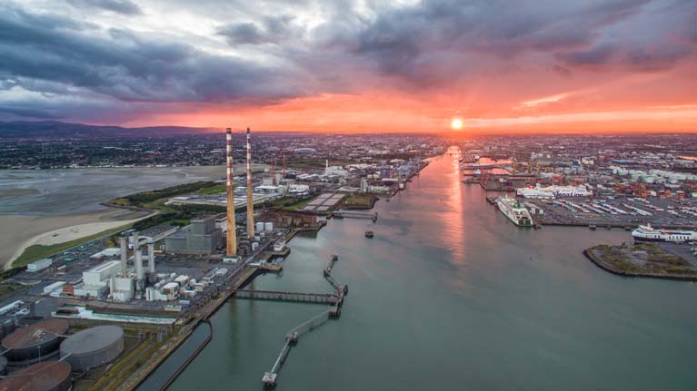
Dublin Port Company has today reported its second-quarter trading figures for 2020. The latest figures show a decline in overall port tonnage of -10.9% in the first six months of 2020.
As Afloat reported previously, having seen a decline of -4.8% in Q1 (which had been attributed to Brexit stockpiling in the first quarter of last year), there was a further and steeper decline in Q2 of -17.0% as the Covid-19 pandemic impacted on the country.
The Q2 decline of -17.0% was less than had been feared following a decline in the month of April of -26.2%. This was followed by a smaller decline of -20.5% in May and by a decline of just -5.5% in June.
Unitised trade (trailers and containers combined) fell by -13.5% to 321,000 units during Q2 with Ro-Ro declining by -13.0% to 225,000 units and Lo-Lo by -14.0% to 173,000 TEU.
Imports of new trade vehicles through Dublin Port in the April to June period decreased by -64.9% to 9,900 and a significant decline appears inevitable for the rest of the year.
Bulk liquid volumes, primarily petroleum products, declined by -37.8% to 715,000 tonnes. Aviation fuel accounts for more than one-fifth of all petroleum imports in Dublin Port and the impact of Covid-19 on air travel has greatly reduced demand. Likewise, reduced car traffic during the lockdown has greatly diminished demand for petrol and diesel.
Bulk solid commodities declined by -20.6% to 388,000 tonnes.
Ferry passenger numbers decreased by -78.2% to 120,000, the great majority of whom were HGV drivers, critical supply chain workers. The number of tourist vehicles fell even further, by -84.2% to 24,000.
There were no cruise ship calls to Dublin Port in Q2 and none is anticipated for the remainder of the year.
Elsewhere, An Bord Pleanála has granted permission for the MP2 Project, the second of three Strategic Infrastructure Development projects required to deliver Masterplan 2040, the development programme designed to bring Dublin Port to its ultimate capacity by 2040.
This permission will allow the construction of two berths with an overall length of 545 metres for Lo-Lo container ships and two berths with a combined length of 572 metres for Ro-Ro ferries. The MP2 Project also provides for the development of a heritage zone overlooking Dublin Bay at the eastern end of Dublin Port as the termination point for the 3.2 kilometre cycle and pedestrian greenway to be built along the northern fringe of the port overlooking the Tolka Estuary. Construction of this greenway will start next year.
Between the ABR Project, which is under construction, and the MP2 Project, Dublin Port Company has now secured all of the planning permissions required for the major development works planned on the northern side of the port under Masterplan 2040.
Commenting on the results, Dublin Port’s Chief Executive, Eamonn O’Reilly, said:
On the Q2 trading results:
“The Q2 decline of 17.0% in cargo volumes was less than we had feared it might be. After the first six months of the year, our volumes are down by 10.9%. At this level, our throughput for the full year would be back to where it was in 2016.
“We saw after the 2008 recession how rapidly the Irish economy can recover from a deep recession and we seem to be seeing some evidence of this resilience in recent months where a 26.2% fall-off in April was followed by a smaller decline of 20.5% in May and by a decline of just 5.5% in June.
“Even during the rapid and deep downturn during Q2, we have seen new unitised services - both Ro-Ro and Lo-Lo - introduced on routes to Rotterdam, Santander and Liverpool and additional capacity added on existing services to Liverpool. We are able to accommodate these because we have been systematically adding to port capacity in recent years.”
On the MP2 Project
“We recently received a 15-year planning permission for the MP2 Project. This will allow us to accommodate the future needs of Ro-Ro and Lo-Lo lines in the years ahead. Given that we have been playing catch-up over the past decade to provide additional port infrastructure for future growth, the drop back in volumes this year gives us some breathing space and it is important that we do not waste the opportunity this gives us to make counter-cyclical investment in port infrastructure.
“The MP2 Project planning permission is for 937 metres of new berths, including an extension to an existing berth. This will allow us to develop 1,117 metres of berths for unitised trade at the eastern end of the port, split 50 / 50 between Lo-Lo and Ro-Ro.
“Dublin Port has two oil jetties through which almost one third of the country’s total energy requirements are imported in the form of petrol, diesel, kerosene and aviation fuel. The MP2 Project planning permission allows for the redevelopment of one of these jetties to provide an additional berth for container ships as and when the demand for fossil fuels permanently reduces in response to national climate change policies.
“The MP2 Project is the second of three Strategic Infrastructure Development projects needed to realise the vision of Masterplan 2040. Work on the first of these – the ABR Project – is well underway. The additional port capacity which these projects will give contributes substantially to the Masterplan’s objective to provide additional port capacity to bring Dublin Port to its ultimate capacity by 2040.
“A second but equally important objective of the Masterplan is to re-integrate Dublin Port with Dublin City and the MP2 Project gives us planning permission to create a heritage area at the eastern end of the port as the destination point for the 3.2 kilometre cycle and pedestrian greenway which we will build along the northern fringe of the port overlooking the Tolka Estuary. Work on the greenway will start next year.
“We are now only 20 years away from the Masterplan’s target date of 2040. Delivering new port infrastructure takes a long time and we need now, already in 2020, to be looking to see how port capacity requirements will be met after 2040. We will shortly publish a series of papers as part of the Dublin Port Post 2040 Dialogue to ensure we have early and comprehensive consultation on this nationally important issue. Long-term planning of large infrastructure is very challenging and cannot start too early.”
As an island nation, Ireland is dependent on ports and shipping services to transport goods, and 90% of our trade is moved though Irish ports.
Shipping and maritime transport services make a significant contribution to Ireland’s ocean economy, with the sector generating €2.3 billion in turnover and employing over 5,000 people in 2018.
The importance of Ireland’s ports and shipping services is the focus of this week’s Oceans of Learning series, with resources from the Marine Institute and Irish Maritime Development Office (IMDO).
Ireland’s maritime industry continues to grow and progress each year with Irish ports and shipping companies making significant investments.
The ports sector in Ireland is currently undergoing a number of expansions and developments — with Dublin Port’s Alexandra Basin development, the development of Ringaskiddy in Cork by Port of Cork and the development of Shannon Foynes Port.
Along with these major investments, shipping companies are also investing heavily in new tonnage, with Irish Ferries, CLdN and Stena leading new build programmes.
IMDO director Liam Lacey said: “The Irish maritime industry can look to the future with confidence. It has shown itself to be resilient and agile in responding to challenges.
“Over the past decade, it has had to respond to the challenges of the financial crisis of 2008, the uncertainty surrounding Brexit and recent challenges. Ireland’s maritime sector has continued to underpin our economy by maintaining vital shipping links for both trade and tourism.”
Oceans of Learning offers downloadable resource such as fact sheets, a quiz and posters on Ireland's shipping sector. To access the resources for this week’s series, visit Port of the Future.
For more information on Oceans of Learning, visit www.marine.ie and follow the Marine Institute on Facebook, Instagram and Twitter.
Dublin Port Company Distributes 500 Care Packs to Seafarers
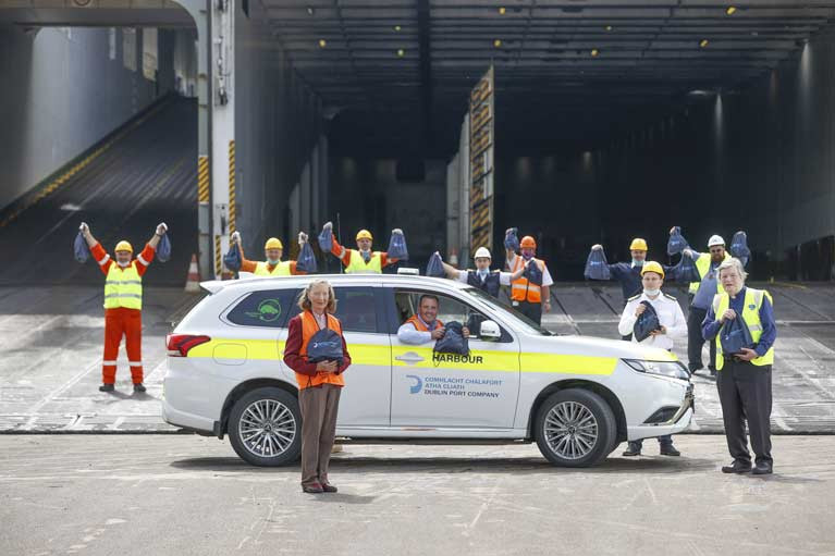
Dublin Port Company today delivered the first of 500 care packs to international seafarers as a thank you for their frontline service during the coronavirus crisis. Due to the pandemic, many members of ships’ crews have had lengthy enforced extensions to their time on board cargo vessels. Crews can typically spend up to 6 months at sea at a time, away from family and home.
Some 300 of the care packs will be distributed amongst the crews of 27 individual vessels which are scheduled to arrive into Dublin Port in the next two weeks. The packs contain essential toiletries, including disposable razors, soap, deodorant, toothbrushes, toothpaste, hand cream, hand soap, lip balm and a nail brush.
Today, the first care packs were given to the crew members of the Victorine, which docked in Dublin Port this morning having completed a voyage between Rotterdam and Dublin as part of a service operated by CLdN.
The remaining 200 care packs will be held by the Dublin Port Seafarers’ Centre and given to the sailors who avail of its services in the weeks and months ahead. The Seafarers’ Centre was opened in 2016 following a €500,000 investment from Dublin Port Company as a vital resource for ships’ crews. It provides amenities such as access to free Wi-Fi, a vital commodity so that seafarers can easily contact family and loved ones while ashore. The Centre supports over 7,500 visiting seafarers a year arriving from all over the world, typically from countries such as India, China, Ukraine, Russia and the Philippines.
Harbour Master Michael McKenna said; “We are delighted to get our Seafarer Care Pack initiative underway today. We at Dublin Port felt like these crew members needed to be acknowledged. They have gone above and beyond in recent months, working during this public health emergency and being confined to their vessels and these packs are a token of our appreciation for the essential service they provide. It’s because of them that we have food on our table, and other essentials at this time.”
Reverend William Black, Port Chaplin from the Mission to Seafarers said; “Looking after seafarers and their basic needs is a huge part of what we do at the centre and we are blessed to be given the opportunity to assist them. They are the essential worker that we all rely on, but not everyone gets the opportunity to see. Today, we wish them well on their homeward journeys and thank them for their service after what has been a difficult time for so many.”
Rose Kearney, manager of the Seafarers’ Centre said; “It is our pleasure to look after these crew members in any way we can. It is a tough world for seafarers, and they have now been away from their families and loved ones for even longer than expected because of the coronavirus. Anything we can do to make their lives a little easier is no problem at all, we are very grateful to them. We hope the packs can give them a bit of comfort before they make their way home.”
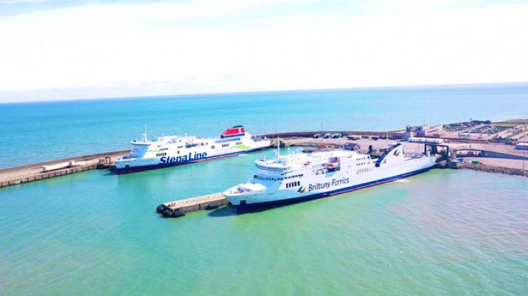
The ferryport of Rosslare Europort will undergo a €30m transformation over the next five years and is the ideal port to alleviate traffic congestion and lessen pollution in Dublin, according to manager Glenn Carr.
As the New Ross Standard reports, Mr Carr said there are 100 acres of land waiting to be developed within a five kilometre radius of the port, an unrivalled landbank in the country, adding that it makes perfect sense for Dublin Port ships and shipping activity to be moved to Rosslare. Planning permission to develop a new access road and entrance has been submitted, with works due to commence this winter - and combined with major plans by the OPW to develop a customs unit at the port - Rosslare Europort is able to take over 20 per cent of activity from Dublin in the coming years.
Mr Carr said: 'Both outside Dublin Port on the M50 and inside, there is congestion. The current situation is not the norm. The norm prior to Covid saw lorries delayed outside the port and even in the port tunnel. With Brexit approaching we do believe that Rosslare has a very strong role to play as geographically it is the closest port to mainland Europe. Companies can save seven hours, (three and a half hours each way) on the Irish Sea on direct services going to Europe.'
He said the Enniscorthy Bypass has saved hauliers 25 minutes on their journey, adding that the opening of the New Ross Bypass has also strengthened the case for the port. For hauliers travelling to distribution centres along the outer M50 in Dublin, Rosslare is now a lot easier to get to. 'The time you would lose on the ship, you'd gain on the road. The New Ross Bypass provides improved connectivity to Cork, Waterford and Limerick, which are main arteries that a lot of product is moved to. We have seen that with the new Brittany Ferries [Bilbao] service, which moved here from Cork. The biggest factor [behind the move] was that the industry wanted the route in Rosslare because it was easier and quicker to get to so there is already evidence that Rosslare is a real alternative to Dublin.
Presently around 84 per cent of roll-on, roll-off shipping activity occurs in Dublin Port, the remaining 16 per cent falling to Rosslare.
For Carr, there is no other port in Ireland better suited to roll-on, roll-off. because of the better access in and out of the port.
For much more on this ferry development click here.
Afloat adds Brittany Ferries were to have launched a second new route out of Rosslare to Roscoff, but due to Covid-19 the start date has been rescheduled to this month. The inaugural sailing is in a fortnight's time, Monday 15th June.
In the meantime Kerry maintains the year-round Spanish service albeit in a freight-only mode until sailings open to passengers return on Wednesday 17th June.
Dublin Port Overall Tonnage Declines by -4.8% in Q1 2020
Dublin Port Company has today reported its first-quarter trading figures for 2020. The latest figures show a decline in overall port tonnage of -4.8% compared to the first quarter of 2019.
The first three months of 2019 were dominated by the original Brexit departure date of 31st March 2019 and volumes through Dublin were very high due to stockpiling. (Q1 2019 imports were 8.0% ahead of imports in Q1 2018).
Against this base, significant growth in Q1 2020 was always unlikely but the impact of the coronavirus, particularly in March, combined with significant shipping disruptions due to bad weather in February caused volumes to decline by 470,000 tonnes or -4.8% in the first quarter of 2020.
Unitised trade (trailers and containers combined) fell by -4.4% to 360,000 units with Ro-Ro declining by -5.3% to 256,000 units and Lo-Lo by -2.2% to 187,000 TEU.
Imports of new trade vehicles
Imports of new trade vehicles through Dublin Port decreased by -10.3% to 30,000 in the first quarter and a significant continuing decline seems inevitable for the rest of the year.
Bulk liquid volumes, primarily petroleum products, grew by +4.4% to 1.1m tonnes. Aviation fuel accounts for more than one-fifth of all petroleum imports in Dublin Port and the impact of the coronavirus on air travel will lead to a large decline in imports of aviation fuel and in overall petroleum imports into Dublin Port in the months ahead.
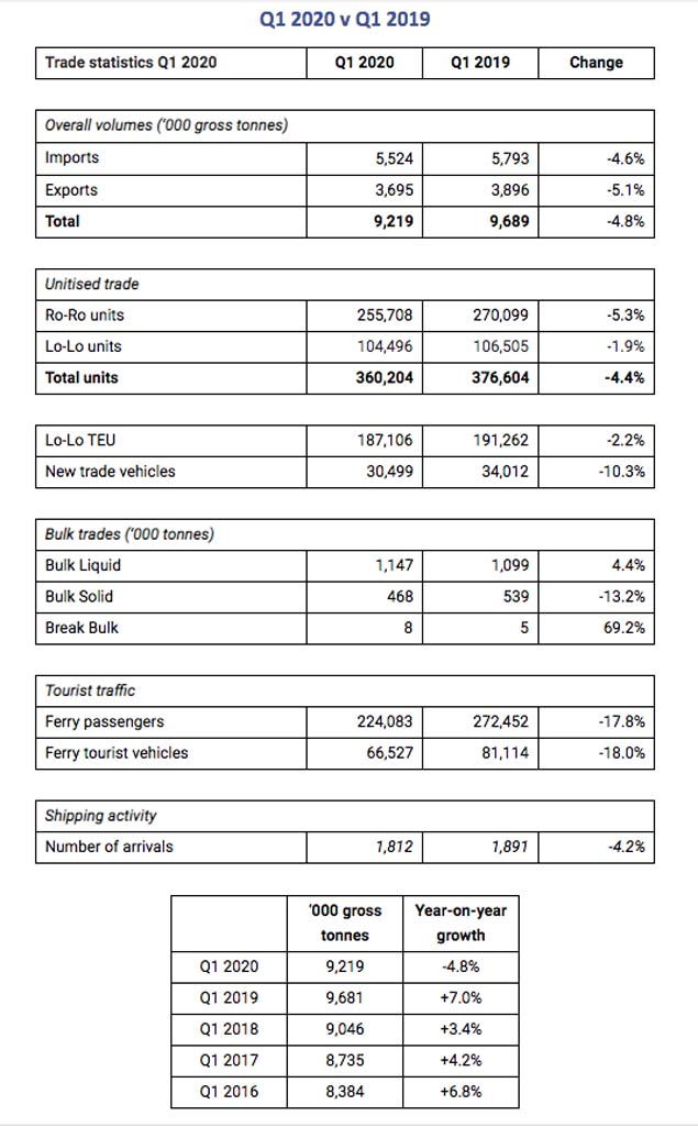
Bulk solid commodities declined by -13.2% to 468,000 tonnes.
Ferry Passengers
Ferry passenger volumes decreased by -17.8% to 224,000. Similarly, the number of tourist vehicles fell by -18.0% to 67,000. One cruise ship called to Dublin Port in Q1 2020 and the outlook for this sector everywhere for the remainder of the cruise season to end-September is bleak.
Commenting on the results, Dublin Port’s Chief Executive, Eamonn O’Reilly, said:
“Against the background of an exceptionally buoyant first quarter in 2019 because of Brexit, we did not expect to see continued strong growth in Q1 2020. However, the combination of exceptionally bad weather in February and the rapid impact of the coronavirus during March has caused port throughput to decline by 470,000 tonnes or 4.8% in the first three months of the year. Although our throughput was behind that of 2019, volumes in Q1 2020 were still ahead of Q1 2018 by 1.9%.
“The not too disappointing figures for Q1 2020 are irrelevant, however, as we look ahead to the second quarter during which we will see a very significant decline in volumes across all cargo modes and in passenger traffic.
“While work on long-term Masterplan development projects will continue once work restrictions are lifted, we will focus determinedly over the next three months on keeping day to day port operations going in order to maintain critical trade flows particularly of foodstuffs, essential consumer goods and medicines. It is at times like this that we see the importance of the supply chains we can normally take for granted in our daily lives.
Keeping Dublin Port open
“Keeping Dublin Port open depends on a small number of critical marine operations, maintenance, security and fire warden staff working 24 / 7. We have adapted normal working arrangements to protect staff and their families to ensure that key functions remain manned at all times and ships can enter and leave Dublin Port safely. We are also delighted to welcome back two recently retired pilots to service to provide additional manpower resilience for this essential function.
“Outside of our own operations, all of the cargo terminals in Dublin Port continue to operate normally and hauliers are maintaining the flow of goods in and out of these terminals. The contribution of port workers, of hauliers and of the anonymous ships' crews who maintain our supply chains is immense.
Dublin Port voluntary redundancy scheme
“In advance of finalising debt facilities of €300m in December 2019, we had been reducing the company’s cost base in recent years notably by way of a voluntary redundancy scheme which is reducing employee numbers by 11% and we are in a good position now to absorb the shock of reduced volumes as a result of the coronavirus in anticipation of economic recovery whenever that might happen. In particular, we are well placed to continue the long lead time challenge of providing additional port capacity for long-term growth”.
Operators of Dublin and Cork ports have said imports of food and other essential items have increased since the Covid-19 outbreak here over a month ago.
According to RTE News, the ports said contingencies are in place to ensure ports stay open and supply chains remain intact.
Their trading figures indicate the Covid-19 outbreak has seen increased demand for food and other essential items.
This is backed up by evidence of panic buying and empty supermarket shelves.
The Port of Cork insists that trade is up and supply chains have been unaffected by the coronavirus outbreak.
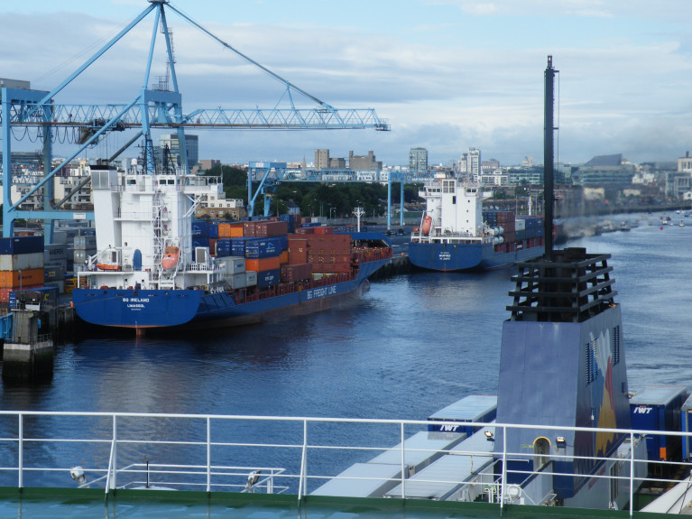
At Cork's deep water terminal in Ringaskiddy, unloading of a Portuguese cargo ship, AS Petronia, began at 5am.
The ship left Costa Rica in Central America a fortnight ago, and tied up in Ringaskiddy in the early hours of this morning.
Ireland is its first port of call. The ship is carrying more than 2,000 shipping containers which are destined for ports all over Europe.
There were around 100 shipping containers for Ireland on board, carrying mangos, melons and pineapples, along with four million bananas - a mere week's supply to keep this country going.
More on this story by clicking here.
In recent months the concept of a fixed link between Ireland and Britain has been rapidly developing as various politicians have proposed bridges between Northern Ireland and Scotland across the narrow, storm-tossed and tide-riven waters of the North Channel.
But while the distance between Fair Head on the northeast corner of Antrim and the Mull of Kintyre in West Scotland is barely 13 miles, as one critic has pointed out, this would be a link “from the back of beyond to the middle of nowhere”. For even when Scotland has been reached at Kintyre, any traffic would have hundreds of miles of driving before getting anywhere near the main road system, let alone the primary motorway routes.
As for a connection across the established ferry route between Larne in Northern Ireland and Stranraer in southwest Scotland, that would also bring traffic from Ireland into a relatively remote part of Scotland, with a long slow drive to the nearest part of the motorway system towards Carlisle in northwest England. That in turn then involves a long haul through the notoriously congested M6 in order to connect with other main routes into the prosperous southeast of England and on into mainland Europe.
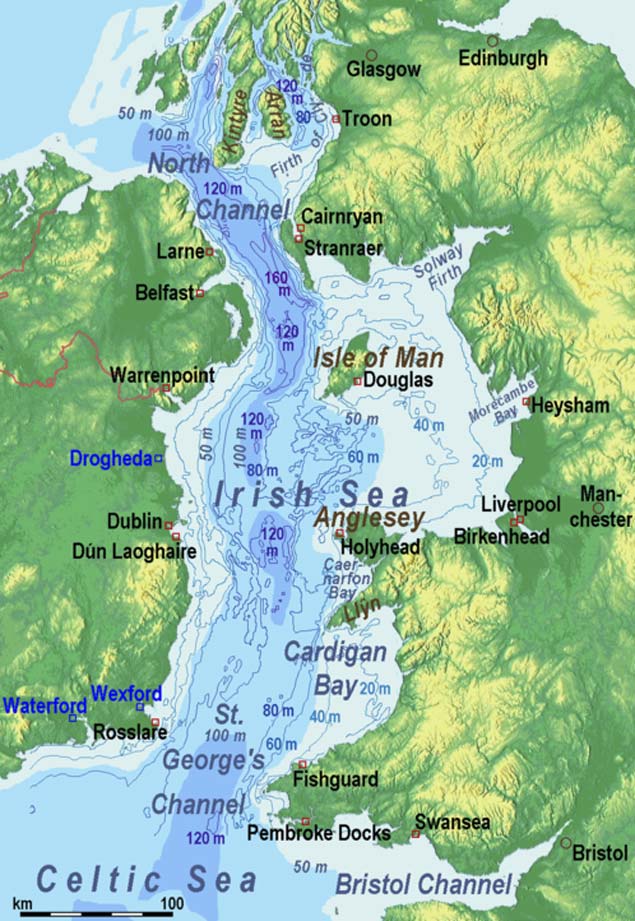 The challenges of providing a fixed link between Ireland and Britain are abundantly clear in this image, with the 160 metres depth of the explosives-filled Beaufort Dyke in the southern North Channel clearly in evidence. In terms of providing a relatively level seabed for the proposed Brunel Link from the greater Dublin area to North Wales, it looks as though a straight line between Skerries and Holyhead would offer the best option
But in any case, it has been pointed out that a Larne-Stranraer link would be considerably longer than the shorter County Antrim link between Black Head in Northern Ireland and Corsewall Point in Scotland. Yet both of these would involve difficult shoreside access, whereas a link slightly further south from Donaghadee in County Down through the nearby Copeland Island and across to Portpatrick in Scotland is only about 20 miles, although putting a motorway through the choice residential districts of North Down and across Copeland Island might meet with some local resistance.
In any case, in this area, the North Channel includes the 160 metres deep fissure which is the Beaufort Dyke, a hidden depth which has the added hazard of use as a dumping group for explosives – millions of them – after World War II ended in 1945. Even after 75 years, there is no reason to assume that they still are anything other than extremely dangerous.
Yet in theory, a viable bridge could be built at this point, for civil engineers reckon anything is possible if they’re only given enough resources to do it. Nevertheless, even though it might be less expensive than a tunnel, it boggles the mind to think of the expenditure which would be required to create a bridge structure which could withstand the really extreme conditions of the North Channel, and thus another idea which has been around for some time has been put forward as a possible solution.
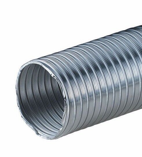 The basic structure of the Brunel Link is very simple. In the completed full-size project, a motorway standard dual carriageway with three lanes either side will be in place across the middle, while a two-line railway will run along the floor.
This is the Bridge/Tunnel, the “Brunnel”, which is somewhere between a bridge and a tunnel. It is in effect a giant tube which is laid along the sea-bed in such a way that it flexibly follows the contours when they are reasonably even, but by its nature, the structure can be reinforced to become a rigid tube-bridge when it is necessary to cross an undersea valley.
As the portmanteau name of Brunnel is so near to the surname of Brunel to remind us of the great Victorian engineer-builder Isambard Kingdom Brunel (who would be just the man for a massive and visionary project of this nature), the concept is becoming known as the Brunel Link. And its potential for being extruded in virtually infinite lengths by a giant (and we really mean giant) tube-making machine from a reinforced mixture of concrete and advance epoxies has been taken into consideration by a mysterious Dublin-based organisation known as the Committee for the Re-Alignment of Ports.
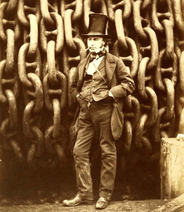 The greatest engineer? Isambard Kingdom Brunel (1806-1859) has been deservedly honoured in the name of the Brunel Link.
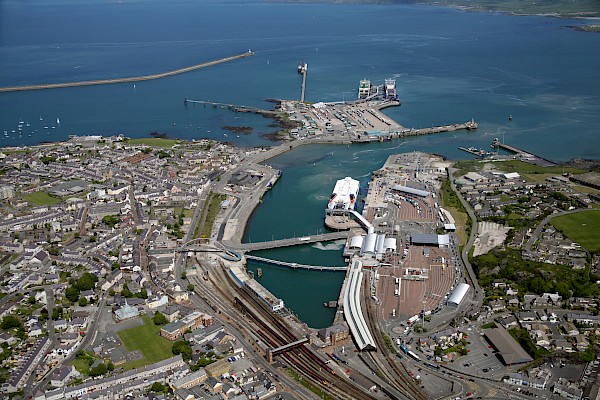
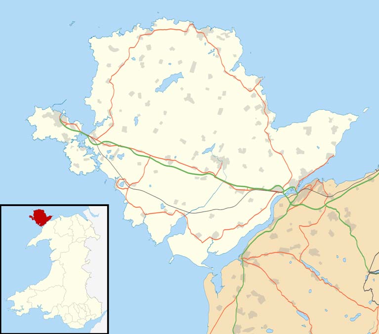
Basically, this Committee is primarily concerned with connecting Ireland as directly as possible with the most prosperous and industrious part of middle and southeast England, which in turn gives connections into the commercial, financial and industrial heartlands of Europe. In order to achieve this, they have concluded that the key arterial route to be followed would be based around the Dublin to Holyhead route.
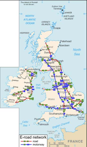 The logic of the Dublin-Holyhead link as the most efficient inter-connector from the island of Ireland to Britain’s industrial and commercial heartlands and on into mainland Europe is evident from this map of the main routes
Thus the Committee’s plan is for a Brunel cross-channel tube connection from somewhere on the coast of the Greater Dublin region to Holyhead, the structure to be of sufficient diameter to accommodate a dual carriageway motorway with three lanes either side, plus vitally important hard shoulders, at its widest horizontal diameter, and below this would be a twin-track railway system running along the Brunel Link floor which will somehow accommodate the differing railway gauges to be found on either side of the Irish Sea.
As the impetus for this huge project is essentially coming from the Irish side, the group behind it plan to invest heavily in Holyhead harbourside property. In fact, one development of this idea is that Ireland should buy Holy Island, the offlyer beside Anglesey on which Holyhead is located, and make it in effect an extension of the Irish Republic. Ideally, in fact, the promoters would like to take over the entire island of Anglesey to provide Dublin with the potential for an easterly extension and its useful hinterland.
 With the Brunel Link in place, the port of Holyhead could have a brighter future as an extension of Dublin Port.
 The promoters of the Brunel Link are thinking in terms of initially taking over Holy Island on which Holyhead is located, and ideally, they hope to buy all of Anglesey in due course to provide Dublin with a viable eastern hinterland.
At the moment that is only the stuff of dreams, but with the Brunel cross-channel connection, the entire geography of the northern area of St George’s Channel would be changed. With Anglesey less than an hour’s drive away from Dublin regardless of the weather, Holyhead could be transformed from an economic blackspot into becoming part of one of Europe’s most successful technical and financial hubs.
This ready access to Holyhead would, in turn, add another option to the regularly-issued demand by high-flown economic commentators and urban planners that Dublin Port be moved entirely out of the city in order to facilitate the “proper 21st Century potential” of the Capital. Those of us who think that the regular and much-observed ship movements in and out of the Port and Dublin Bay are integral to the character of the city may disagree with this, but nevertheless it’s interesting to see how the Holyhead option may affect the overall thinking.
For the “Move the Port out of the City” movement assumes that somewhere else can be conveniently found to place the large and complex infrastructure of Dublin port. Yet no remotely comparable natural harbour exists any nearer than Carlingford Lough to the north, and Wexford Harbour to the south, while the proposals for a new port at Bremor close north of Balbriggan seem to take no account of the need there would be for the construction of massive new breakwaters to create an artificial harbour which would have to be many times the size of Dun Laoghaire.
Yet with Holyhead brought into the equation through the Brunel Link, valuable land on the East Coast of Ireland could be retained for residential and recreational use, while an under-utilised industrial area and harbour on the Welsh coast could be brought to life as an extension of Dublin port.
 Sunset for Dublin Port? With ferry operations removed by the opening of the Brunel Link to Holyhead, and with Holyhead thereby enabled to take over the freight services of Dublin, the way would be clear for the Dublin port area to be re-developed for residential, office and recreational use.
Behind all this re-alignment of ports, the new arterial connection from the heart of Ireland through Britain to the heart of Europe would be made even more viable in several obvious ways. With the rapidly increased use of electrically-powered vehicles in the near future, the convenience and environmental compatibility of the Brunel Link, and the inescapable logic of its location, arguably make the visionary proposals from the Committee for the Re-Alignment of Ports a real no-brainer.
Sea Trade for Dublin Port Set for 17% Hit Due to Covid-19
Dublin's sea trade which is around 17% could be affected by the coronavirus pandemic according to the Dublin Port Company.
It a statement the company says it "fully expects" a fall-off when the next quarterly results are published.
It says that 17% of trade in the port is with deep sea destinations such as China, which are "exposed" to the impact of the virus.
"We know that we will see a reduction in volumes affecting this portion of our trade, but we cannot comment meaningfully on the impact until after the end of the first quarter".
More on the story RTE reports here.
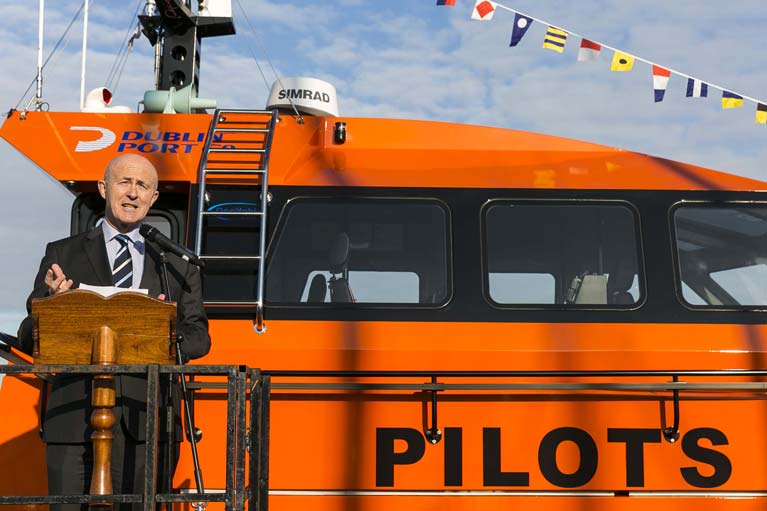
New Dublin Port Pilot Boat 'Tolka' Christened
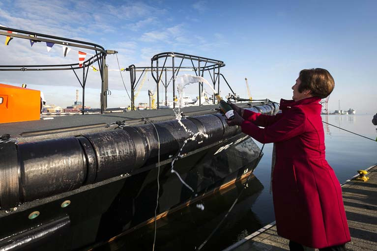
Dublin Port Company has today officially christened its new Pilot Boat, DPC Tolka, in a short ceremony held at Poolbeg Yacht Club. The state-of-the-art vessel arrived in Dublin Port in December.
Father Ivan Tonge of Ringsend Parish and Reverend William Black, Port Chaplin from the Mission to Seafarers, blessed the 17.1-metre vessel before the boat’s godmother, Eileen Murray, carried out the traditional smashing of a champagne bottle on its bow. Eileen, a local of Ringsend, is the Vice Commodore of Poolbeg Yacht Club and her father was one of its founding members.
 Eamonn O’Reilly, Chief Executive of Dublin Port Company Dublin at the Tolka Christening ceremony
As Afloat reported previously, DPC Tolka is the newest addition to the port’s fleet of working vessels, which includes tug boats Shackleton and Beaufort, multi-purpose workboat the Rosbeg, and pilot boats Liffey and Camac. She replaces the Port’s oldest pilot boat Dodder, which was retired from service after 23 years.
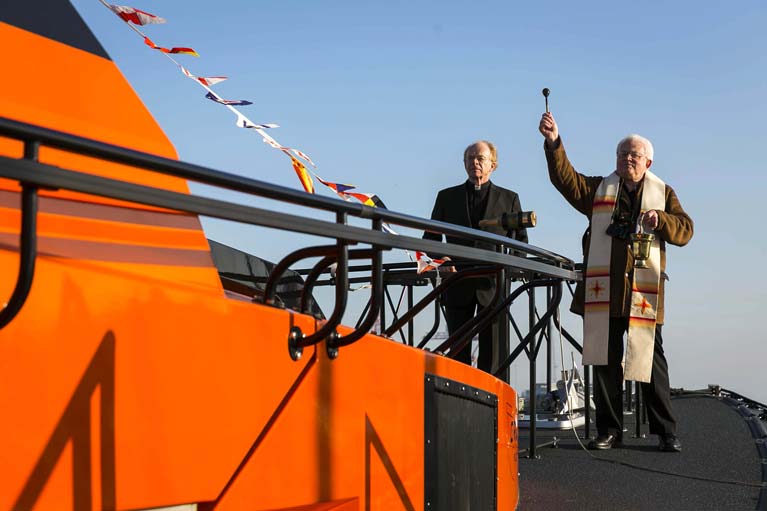 Father Ivan Tonge of Ringsend Parish and Reverend William Black, Port Chaplin from the Mission to Seafarers, blessed the 17.1-metre vessel
DPC Tolka represents a vital upgrade in the provision of pilotage services at the Port and will allow Dublin Port’s team of highly skilled marine pilots to reach and board large ships in all weather conditions from a greater distance out into Dublin Bay. Pilots have been training on the new vessel since her arrival.
Eamonn O’Reilly, Chief Executive, Dublin Port Company, said: “The christening of a new vessel is a longstanding tradition and I cannot think of a more suitable godmother to the Tolka than Vice Commodore Murray, whose family are steeped in Poolbeg Yacht Club’s history. I thank Eileen and the Club for hosting this event today and Dublin Port looks forward to continuing to work closely with both the local community and sailing organisations in the future.”
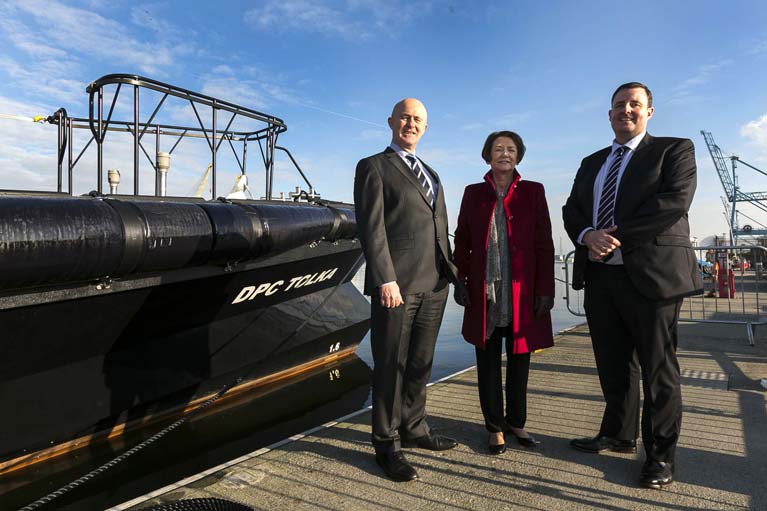 (From left) Dublin Port CEO Eamonn O’Reilly, Eileen Murray and Dublin Port Harbour master Captain Michael McKenna
Hopes High for Dublin Dock Workers' Preservation Society Photo Archive
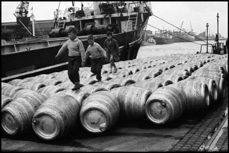
Good news from the Dublin Dock Workers' Preservation Society in their attempts to save their 6,000 historical photographs collection. The problem was reported earlier this week on Afloat.
Declan Byrne of the Society says: "We have been overwhelmed by the offers of help and support to preserve our archive. We are meeting up with Lar Joye Port Heritage Director of Dublin Port Company"
Hopefully, there will be a positive outcome and the important collection will be saved.


 Michael Murphy Schull Harbour Sailing Club (SHSC), Eric Coogan Heineken Ireland, Mark Murphy, Commodore SHSC, Jack Allen SHSC, Carmel O'Regan SHSC, Cornelious Ndlovu, Schull Harbour Hotel Operations Manager and Derval Murphy SHSC")

