


Displaying items by tag: marine science
Marine Notice: Deployment Of Scientific Moorings At Goban Spur
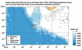
#MarineNotice - The latest Marine Notice from the Department of Transport, Tourism and Sport (DTTAS) advises that the German Federal Maritime and Hydrographic Agency (BSH) and the University of Bremen will deploy three scientific deep-sea moorings at Goban Spur off the southwestern Irish shelf.
The work will be carried out by the German research vessel Maria S Merian (Callsign DBBT) and is expected to start on or around Sunday 3 April, lasting for approximately five days, weather permitting.
The top elements of all three moorings are yellow or orange in colour and carry flags as well as radio and Iridium beacons that only signal once the top element is at the surface. Scientific instruments are attached at different depths to ropes and chains. Sub-surface floatation bodies will keep the moorings upright.
As this is sensitive scientific equipment it is requested that fishermen and marine operators engaged in such activities as bottom trawling or laying of static gear avoid the locations concerned.
The moorings will be in place for a period of 12-15 months and will be positioned at the locations detailed in Marine Notice No 12 of 2016, a PDF of which is available to read or download HERE.
Mini Research Vessel Returns To The Sea
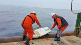
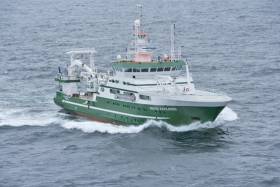
#CoastalNotes - Marine Institute researchers assisted marine technology students from Cape Fear Community College in the USA by deploying their miniature marine research vessel from the RV Celtic Explorer last Sunday 20 March.
The students in Cape Fear Community College’s boat building programme spent two months building Marlin Spikin’ Miller, which washed up on the shores of a Connemara island recently some eight months after being put to sea 6,000 miles across the Atlantic, as previously reported on Afloat.ie.
The boat is a miniature fibreglass sailboat designed to journey with the ocean winds and currents. It is embedded with a small satellite transmitter mounted on the deck and sends back data to the students which they use to monitor ocean and wind currents.
Cape Fear's boat building programme is unique in its kind and is part of a project in which a handful of schools across the USA are included.
Ciaran O’Donnell of the Marine Institute commented: “We are delighted to have this opportunity to play a role in this project and will look forward to seeing where the vessel will end up next.”
The Celtic Explorer launched the Marlin Spikin’ Miller at the most south-westerly point of the current blue whiting acoustic survey off the coast of Ireland.
The survey will run for another fortnight and will assess the size of the spawning stock of blue whiting in western waters. Ireland has participated in the international survey programme since 2004.
Acoustic data, age and maturity of blue whiting samples from all participants are combined to provide a measure of the relative abundance of the blue whiting stock.
The annual abundance estimate and stock numbers at age are presented to the ICES Working Group of Widely Distributed Stocks (WGWIDE).
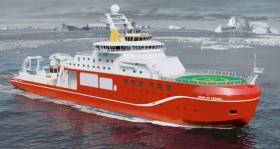
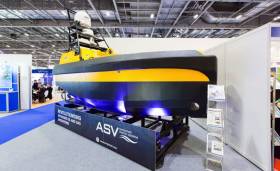
#BoatyMcBoatface - The operators of a new British marine research vessel may be left red-faced as an online poll to name the ship has a clear favourite: Boaty McBoatface.
The tongue-in-cheek submission is far ahead of rival choices such as David Attenborough in the public vote to name the Natural Environment Research Council's (NERC) new polar research ship, as The Independent reports. SEE VIDEO BELOW.
And it's not the only witticism in the running, with Usain Boat, Ice Ice Baby and Notthetitanic also proving popular on social media ahead of the voting deadline on 16 April.
Whatever name it eventually gets, the £200 million (€253 million) vessel will carry up to 90 scientists and support staff on lengthy research voyages to the Arctic and Antartica, forming part of what NERC describes as "the most advanced floating research fleet in the world".
The Independent has more on the story HERE.
Blue Whiting Acoustic Survey Begins For 2016
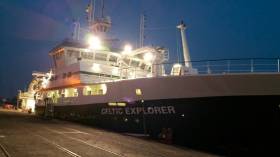
#MarineScience - Marine scientists on board the RV Celtic Explorer have posted their first blog entry from this year's blue whiting acoustic survey voyage.
Setting sail from Cork on St Patrick's Day last week, the team – comprising acousticians, biologists and marine wildlife observers – are preparing to cover a massive area between the West of Ireland and the west coast of Scotland, including Rockall, as part of a flotilla of international research vessels from the Netherlands, Norway and the Faroe Islands.
Applications Open For Scientific Eel Fisheries
#Eels - Inland Fisheries Ireland is in the process of setting up a network of scientific fisheries for eel around Ireland.
These scientific fisheries will cover the different life stages (elver, yellow and silver eel) and be distributed in key catchments around Ireland.
The purpose of the fisheries is to increase the data and knowledge of eel in Ireland ahead of the next EU review in 2018 which will help inform management on the state of the eel stocks as part of the Eel Monitoring Programme.
Details of the type of fisheries and the locations is outlined in the application document HERE.
IFI requests that former eel fishermen apply, and include an application specifying which of the locations and life stages they are interested in applying for.
The engagement of services will be a rolling contract – reviewed on an annual basis likely to extend for a period of three years, subject to an annual review and funding.
The research fishery will be authorised with the successful application of a certificate of authorisation under Section 14 of the Fisheries (Consolidation) Act, 1959 as substituted by Section 4 of the Fisheries (Amendment) Act, 1962. IFI will engage with the applicants in relation to the successful operation of the research fisheries.
Any questions in relation to the scientific eel fisheries can be sent by email to [email protected] or in writing to:
Scientific Eel Fishery
Inland Fisheries Ireland,
3044 Lake Drive,
Citywest Business Campus,
Dublin 24
D24 Y265
The closing date for applications is Friday 15 April 2016.
Marine Institute Promoting Ireland as 'Centre for Innovation in the Sea' at Oceanology
The Galway based Marine Institute and some of Ireland’s most innovative marine technology organisations are in London this week at one of the leading global ocean technology events, Oceanology International, at ExCel London (March 15-17). They are promoting Ireland as a centre for innovation in the sea and an ideal location to develop and test novel marine technology because of Ireland's marine research infrastructure and marine innovation clusters.
See a full list of the Irish exhibitors below.
Dr Edel O’Connor, Coordinator of the national marine technology programme said, “This is one of the largest ever representations of Irish organisations at Oceanology International. Irish companies are developing innovative products and services that are being exported internationally. The conditions are being put in place to ensure Ireland is at the forefront of expertise and investment opportunities in a growing global blue economy.”
Ireland is developing a critical mass of research and innovation activities in marine technologies through the development of innovation clusters and investment in a suite of world-class test and development infrastructure. One such development, the SmartOcean initiative is building on Ireland’s existing cohort of ICT and engineering SMEs and multinationals to drive innovation in new and unanticipated ways to support the sustainable development of its large-scale ocean territory and to develop products and services for the global blue economy.
The Ireland Pavilion includes Irish SMEs Geomara, JFC Marine, TFI Marine, SonarSim, Marine Technology Ltd., and the Entrepreneur Ship which represents a number of SMEs based on the IMERC campus in Cork. Irish research platforms and infrastructures will also be showcased as part of the Pavilion. These include the marine energy and ocean technologies test site and sub-sea cabled observatory in Galway Bay; the national marine research vessels, RV Celtic Explorer and RV Celtic Voyager; and INFOMAR, the national seabed mapping programme managed by the Marine Institute and Geological Survey of Ireland. Other Irish SMEs such as Cathx Ocean and IDS monitoring are also showcasing their innovative products and services at the trade show. This year the Marine Institute, Enterprise Ireland and IDA will also speak at the inaugural international trading sessions at the event to showcase Ireland as a destination for expertise in marine ICT.
Exhibitors on the Ireland Pavilion
|
The Entrepreneur Ship |
The Entrepreneur Ship is the world's first dedicated Blue Tech and Energy co-working space for startups and larger companies seeking touchdown space in Cork, Ireland. We are part of Ireland's Maritime Cluster, IMERC. Companies joining us on our stand include SEA-Tech, Exceedence and MUX’. |
|
TFI Marine |
TfI Marine supplies elastomeric mooring tethers that reduce mooring loads by ~ 70% and protect against shock loads. They reduce both capital and maintenance costs and are available for use in mooring Data Buoys; Aquaculture Cages and Feed Barges; Marine Energy devices and Oil and Gas structures. |
|
Marine Technology Ltd |
Established in 1980, Marine Technology Ltd is a precision engineering, design and development company. We specialise in the design and manufacture of bespoke marine projects, and across a range of other industries. We also specialise in batch production work of subsea components or one-off designs. |
|
SonarSim |
SonarSim provide smart software to improve the efficiency of underwater SONAR workflows & operations. We offer real-time Multibeam, Sidescan, & Imaging SONAR processing, automation & simulation solutions to support enhanced Hydrographic training, survey planning, mapping & security applications. |
|
JFC Marine |
JFC Marine offer an extensive range of floating buoy structures for both Navigation and Data buoy acquisitions. Our in-house R&D department are capable of providing custom build solutions integrating new technologies and data sensors, supplying real-time information to pilots at sea. |
|
Geomara |
Subsea Survey, Asset Protection and Intervention. |
|
Marine Institute |
The Marine Institute is promoting Irish marine research infrastructure; including the cabled seafloor observatory, national Research Vessels, the INFOMAR seabed mapping programme (joint programme with the Geological Survey of Ireland and MI) and the digital Ocean. SmartBay Ireland is the national test & demonstration facility for technology and ocean energy. |
|
SmartBay Ireland |
|
|
INFOMAR |
Research Vessel Users Workshop In April
#MarineScience - The research vessel operations team at the Marine Institute are hosting a workshop for research vessel users at the institute's Oranmore headquarters on Thursday 28 April.
The aim of the workshop is to give marine scientists across a range of disciplines the opportunity to discuss their research, and their experience on both the RV Celtic Explorer and RV Celtic Voyager, as well as using the ROV Holland 1.
It will also allow the research vessel operations team to highlight the capabilities of both research vessels post 2015 refits, and to gather feedback about how the service could be improved.
The meeting will commence at 9am and it is planned to finish at 6pm. There will be an opportunity to have a Q&A session around the talks and gather feedback from both the user and the service provider. Contact [email protected] with any queries.
The research vessel users workshop will be followed by a SMARTSkills day workshop also in Oranmore on Friday 29 April with training sessions on the following:
- MaxSea plotting software.
- Shipboard Computer System (SCS) training.
- IxBlue Echoes Sub Bottom Profiler training: practice and processing.
- CTD training.
- ADCP training.
- Kongsberg Multibeam operating system (SIS).
All of the above equipment will be available for hands-on training and there will also be a wide selection of other scientific equipment on display on the day. See the SMARTSkills website for further information. A draft agenda for the SMARTSkills training can be found HERE.
Marine Institute Hosts Kenyan Delegation
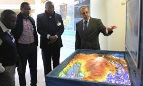
#MarineScience - On Wednesday 17 February the Marine Institute hosted a delegation of officials from the Kenyan Ministry of Agriculture, Livestock and Fisheries.
The delegation, headed by Micheni Ntiba, Secretary General of the Ministry of Agriculture, Livestock and Fisheries, was greeted by Dr Paul Connolly, director of fisheries ecosystems advisory services, who gave an overview of the work carried out at the Marine Institute and highlighted the extensive range of research vessel surveys that support fisheries management.
Tommy Furey of INFOMAR demonstrated how we can map the seabed using the latest technology and also demonstrated the importance of topography, contouring, geology and seabed mapping with Ireland’s first augmented reality (AR) sandbox.
The AR sandbox is based on a concept first developed as part of a National Science Foundation (NSF) funded project lead by visualisation collaboration KeckCAVES at the University of California.
The Delegation toured the building to get a first-hand glimpse of the work undertaken, visiting the biotoxin lab to learn about the work involved in the biotoxin monitoring programme, and the underwater TV survey lab, viewing footage of the burrows of Dublin Bay prawn (Nephrops norvegicus), getting an insight into some of the services provided to the Irish Government.
The delegation remarked that they could see may ideas that could be used in Kenya and that they could learn a lot from the Irish experience with Harnessing Our Ocean Wealth.
Kenya is very interested in developing an integrated marine plan for their ocean resources and the delegates were very interested to hear about Ireland’s Harnessing Our Ocean Wealth strategy and how it has progressed.
There is a new acceptance in Kenya on the importance of the ocean and its potential to contribute to the Kenyan economy.
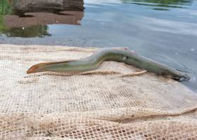
US College's Research Vessel Washes Up On Galway Island
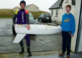
#CoastalNotes - An American college's unmanned research vessel has been found on the shores of a Connemara island some eight months after students put it to sea 6,000 miles across the Atlantic in North Carolina.
As Port City Daily reports, the Cape Fear Community College (CFCC) vessel, appearing like a miniature sailboat, was discovered recently with its mast broken off on the coast of Illaunurra by kayaking father-and-son duo Keith and Graham Roberts.
Inside the boat, they found instructions on who to contact if it were recovered – which is how CFCC marine science teacher Jacqui Degan and her class learned the fate of their project.
Marlin Spikin’ Miller, as the boat was named, is one of two fibreglass boats kitted out with transmitters that the students set adrift south of Wilmington, North Carolina.
And that it survived its long-distance journey over many months relatively intact is a testament to the college's boatbuilding students, who collaborated with the science department on the project
Port City Daily has more on the story HERE.
Westport To Host Sea Lice Conference This September
#MarineScience - The 11th International Sea Lice Conference will be hosted by the Marine Institute in Westport, Co Mayo from 26-28 September 2016, it has been announced.
This biennial gathering of the world's most prominent sea lice research will hear the latest papers, presentations and posters of the most up-to-date research in the field – such as last year's paper that identified salmon farming's impact on wild salmon and sea trout stocks.
The goal of the conference is to bring together leading international researchers, groups and regulatory agencies to foster collaboration and communication on sea lice research and to advance our understanding of the key biological, environmental and management factors associated with sea lice in both wild and farmed settings.
Presenters will be invited to submit papers which may be published in the Journal of Fish Diseases as a special edition.
Registration is now open for prospective presenters, who should also submit abstracts of their research. A limited number of scholarships for students are also available.
For more information visit the conference website HERE.


 at 10am, meanwhile can anyone tell us more about the white cruising yacht in the background here?")


, at the sod-turning event for the new Deep Water Quay Development at the Rossaveal Fishery Harbour Centre. (Forbairt Ché Dhomhain, Lárionad Chuan Iascaigh Ros An Mhíl) in February")

