


Displaying items by tag: Marine Institute
Bluefin Tuna Data Collection Fishery Programme Returns for 2021
Building on the success of pilot programmes in 2019 and 2020, the Tuna CHART (CatcH And Release Tagging) fishery to collect scientific data on bluefin tuna will return in 2021, subject to COVID-19 restrictions.
Tuna CHART is a collaborative scientific programme between Inland Fisheries Ireland and the Marine Institute in partnership with the Sea Fisheries Protection Authority, the Department of Agriculture, Food and the Marine (DAFM) and the Department of Environment, Climate and Communications (DECC).
In 2020, the Tuna CHART programme authorised 22 charter skippers to operate a scientific fishery — in which anglers participated fully — to catch, tag and release bluefin tuna. These professional skippers were trained to tag, measure and record bluefin data.
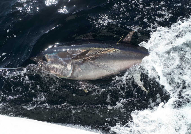
Despite the limitations of the pandemic, 685 bluefin tuna were caught, tagged and released around the Irish coast — a 230% increase in bluefin tagged on the previous year.
 File image of bluefin tuna in Donegal Bay Photo: David Morrissey
The most productive sites were the North-West and the South coast, mainly the waters of the Cork coastline. As many as 11 bluefin were tagged on one angling trip, a new Irish record. The largest tuna tagged was 275cm, weighing an estimated 822lbs.
All tuna were carefully handled subject to strict guidelines set by the Tuna CHART programme and all were released alive. Data from the tagging programme has been collated by the partnership for reporting to the International Commission for the Conservation of Atlantic Tuna (ICCAT).
This year a maximum of 25 authorisations may be granted to qualifying vessels and skippers around the Irish coast for fishing between 1 July and 12 November. Applications are now open and will be accepted until 1pm on Friday 9 April.
Depending on the successful operation and review of this year’s fishery, it is intended that a scientific catch-and-release fishery may also operate in 2022.
The partnership says a core aspect of the Tuna CHART programme is the welfare and successful release of the bluefin tuna. Authorised skippers will be required to have high specification rods, reels and line in advance of the open season in order to ensure that the fish is brought alongside the vessel to be measured and tagged in the water in a timely manner.
Data collection for scientific assessment is the primary purpose of the fishery and will continue to be a key requirement for skipper participation in this scientific catch-and-release fishery, the partnership adds.
Skippers will be required to collect data on every bluefin trip undertaken and each bluefin tuna they catch, tag and release, and their angling and data recording expertise is an important part of the overall survey programme.
Anglers will have an opportunity to participate in this fishery and contribute to this important scientific study by chartering and fishing from authorised vessels only. Unauthorised vessels are not permitted to target or catch bluefin tuna, and any unauthorised person found to be targeting bluefin tuna will be prosecuted. Applications for authorisations are open to charter skippers only.
Irish Whale & Dolphin Group to Provide Marine Mammal Observer on Upcoming Fisheries Surveys
The Irish Whale and Dolphin Group (IWDG) won the tender to provide a marine mammal observer on three fisheries acoustic surveys with the Marine Institute this year.
These include a survey for blue whiting this month, the Western European Shelf Pelagic Acoustic (WESPAS) survey during June and July and the Celtic Sea Herring Acoustic Survey in October.
The aforementioned missions are annual stock assessment surveys and cover a huge area of the Irish EEZ.
Data on higher trophic predators such as marine mammals and seabirds are essential to provide the data to support the development of an ecosystem approach to fisheries management.
Experienced offshore surveyor Dr Justin Judge will be joining each cruise to record all sightings of whales and dolphins and other interesting endangered, threatened and protected (ETP) species, as well as recording the vessels’ track and environmental conditions.
He follows in the footsteps of Dave Wall, who used data collected from these annual surveys in 2014 to built the dataset to publish the first Offshore Atlas of Marine Mammal Distribution.
Aquaculture Advances in Marine Institute Researchers Showcase at Burrishoole Research Day
On Thursday 25th February 2021, the Marine Institute will host the Burrishoole Research Day, a virtual symposium showcasing the wide network of researchers connected to the Marine Institute’s Newport Research Facility in Co Mayo.
The symposium will include short talks from 26 researchers representing seven Irish and UK Higher Education Institutions, including the Marine Institute. Researchers will share insights into their research projects and advances in areas such as climate change, fish telemetry, genomics, aquaculture and ecological change.
The Newport Research Facility in Co Mayo has been in operation since 1955, and has been part of the Marine Institute since 1999. Located at the base of the Burrishoole catchment, the facility is located at the interface of the freshwater and marine ecosystems. The combination of the unique location, and long time series of environmental datasets have attracted national and international researchers to the facility for many decades.
Fisheries research at the Newport Research Facility focuses on migration, ecology, genetics, population dynamics and management advice for species including salmon, sea trout, eel, sea bass, blue fin tuna, pollack and stickleback. There are also a range of research projects on the impacts of climate and land use change on aquatic ecosystems, limnology, oceanography and sustainable aquaculture.
Researchers based at the Marine Institute’s Newport Research Facility have secured competitive funding in a number of research areas. As part of the Marine Institute’s Cullen Scholarship Programme, a number of postgraduate students have also been based at the Newport Research Facility to work on projects relevant to the Marine Institute whilst studying for a higher degree. The resulting research network, encompassing researchers from the Marine Institute and Higher Education Institutes, is diverse and collaborative. This symposium will highlight progress on research projects in the last three years, as well as introduce some new projects.
The symposium will include four sessions via Zoom from 10am to 4pm on Thursday 25th February 2021. To access the programme and the Zoom link, email [email protected]
Marine Institute Recruiting for Oceanographer
The Marine Institute is recruiting for a physical oceanographer to join its existing team of oceanographers and modellers to gather, analyse and generate services from oceanographic data.
The oceanographer will support the institute’s data collection at sea and work with data management colleagues to robustly archive, quality assure and analyse the oceanographic datasets of interest to users.
These include — but are not limited to — tide gauges, offshore weather buoys, conductivity, temperature and depth (CTD) profiles from ships, CTD from moored platforms, ocean gliders, Argo floats and acoustic Doppler current profilers (ADCP).
This temporary specified purpose contract of employment, providing redeployment cover, will run for up to 31 December 2023. The successful candidate will be on probation for the first six months.
A detailed job description is available from the Marine Institute website, and the closing date for applications is Wednesday 24 February at 12 noon.
Female Marine Scientists on the Crest of a Research Wave
Some 30 per cent of researchers worldwide are female, according to UNESCO which marks International Day of Women and Girls in Science this week
About 35 per cent of all students in STEM-related fields – that’s science, technology, engineering and maths – are women, UNESCO says.
However, about 51 per cent of staff at the Marine Institute in Galway are female, and about 70 per cent hold key roles in science, technical analysis and research, extending from oceanography and ocean climate to fishery ecosystems, marine environment and food safety.
Marine Institute director of corporate services Patricia Orme says the organisation also has women working in policy, innovation and research, maritime development and corporate roles.
“We are extremely proud to note that 80% of our female employees hold bachelor, masters or doctorate level qualifications," she says.
Wavelengths spoke to three of those women – starting with postdoctoral researcher Julia Calderwood who is involved in designing what will be a very useful app for the fishing industry to help reduced unwanted catches as part of the IFish project funded by Science Foundation Ireland.
 lizabeth Tray, from North Carolina, is team leader for data co-ordination and reporting on marine spatial planning
Elizabeth Tray, from North Carolina, is team leader for data coordination and reporting on marine spatial planning and the EU’s Marine Strategy Framework Directive.
Yvonne Bogan from Donegal took her PhD in marine biotoxins and formerly worked with the Environmental Protection Agency. She is now quality manager team leader with the Marine Institute.
 Yvonne Bogan, a quality manager team leader with the Marine Institute
For more profiles of female scientists in marine research, follow #WomenInScience on the Marine Institute’s Facebook, Twitter and Instagram pages.
You can listen to Wavelengths below
Marine Institute’s Bursary Scholarship Programme Now Open for Student Applications

The Marine Institute is inviting marine science undergraduates to apply for a number of work experience placements as part of the 2021 Summer Bursary Scholarship Programme.
This year the programme will offer a number of eight- to 12-week placements for up to 11 undergraduate students who will be based at either the Marine Institute headquarters in Oranmore, Co Galway or the research facility at Newport, Co Mayo.
The programme offers students practical experience in areas such as freshwater fisheries, salmon scale archiving, aquaculture, oceanography data sets, marine infrastructure asset management, finance, human resources and marine communications.
As previously reported on Afloat.ie, the Bursary Scholarship Programme has been running for over 30 years, providing essential career development and support, and inspiring the next generation of marine scientists and experts. It is aimed at undergraduates of universities, institutes of technology and national institutes for higher education.
To participate in the programme, undergraduate students must have completed two years of study in a relevant discipline by the beginning of June 2021. Successful applicants will receive a scholarship worth €275 per week for the duration of the work placement.
To apply for the 2021 Bursary Programme:
- View the bursary titles available
- Select the two bursary positions that interest you the most and in order of preference
- Complete the application form and return it FAO Helen McCormick, Marine Institute, Rinville, Oranmore, Galway, H91 R673
The application deadline date is Friday 26 February.
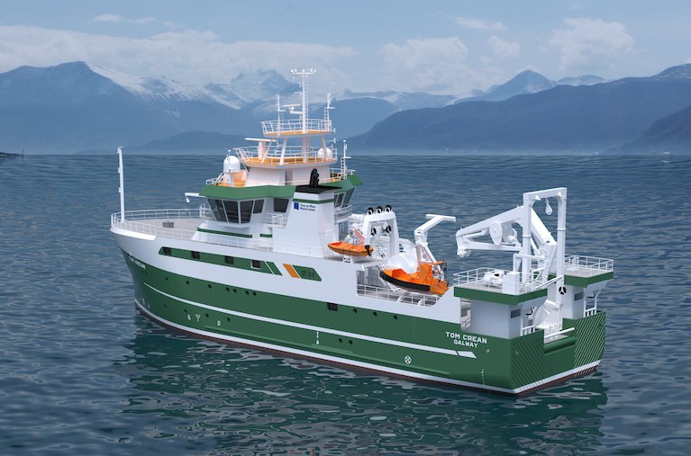
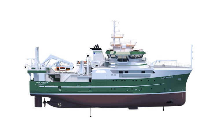
As Afloat first highlighted the Marine Institute's name of RV Tom Crean chosen for the new €25m research vessel due for delivery in Autumn 2022, is to feature a suite of the latest state of the art technology equipment, writes Jehan Ashmore.
RV Tom Crean of 52.8m will be one of world's most advanced research vessels is to directly replace the smaller RV Celtic Voyager of 31.40m and of 23 years service having operated duties in more inshore waters.
While the larger fleetmate, RV Celtic Explorer of 65.5m dating to 2003 will be joined by the newbuild to carry out an extensive capability of marine research activities. They include vital fisheries data (incl. EU Common Fisheries Policy), Irish seabed mapping (INFOMAR) and oceanography and critical climate change related research given this year marks the start of the UN Decade of the Ocean (2021-2030) and its urgency.
The newbuild was commissioned by the Department of Agriculture, Food and the Marine with the approval of the Government of Ireland, to enable the State's national integrated marine plan, 'Harnessing Our Ocean Wealth' and the national Marine Research and Innovation Strategy.
Afloat can also reveal that RV Tom Crean will be around 1,900 gross registered tonnes, with the first block laid down on 4th November last year at the Spanish shipyard of Astilleros Armon Vigo S.A. So far, 19 out of 32 block sections constructed are in place, with September 2021 scheduled for starting a 'fitting-out' period of the semi-completed newbuild prior to the newbuild's commissioning around a year later.
The shipyard is working to a design of Norwegian naval architects, Skipsteknisk AS based in Ålesund which was awarded the work following a EU tender process. The design consultancy were also responsible for the RV Celtic Explorer which will be joined by RV Tom Crean in the M.I.'s homeport of Galway, strategically located on the western seaboard and with easy access to the North Atlantic Ocean.
Afloat contacted the Marine Institute since (their press release), for further details of the RV Tom Crean characteristics, in particular the all important aft work deck, where the primary action is to take place in water operations in depths down to 4,000m.
According to Aodhán FitzGerald, Research Vessel Manager of the MI, the RV Tom Crean will feature an articulated boom crane aft (6t@ 10m, 3T@ 15m), located on the aft-gantry. This will be largely used for loading science equipment and net and equipment handling offshore.
Mounted at the stern is a 10T A frame aft which can articulate through 170 degrees which is for deploying and recovering large science equipment such as remotely operated vehicle (ROV’s), towed sleds and for fishing operations.
The vessel also has a heave compensated CTD system (system for measuring water temperature, salinity and depth and for collecting water samples) consisting of a deepwater winch and Frame to allow CTD operations in water depths down to 4000m.
Part of the equippment will be a regulation MOB boat on a dedicated davit and the facility to carry a 6.5m Rigid Inflatable tender on the port side.
Also at the aft deck is where the 'Holland 1' Work class ROV and the University of Limericks 'Etain' sub Atlantic ROV will be positioned. In addition up to 3 x 20’ (TEU) containers can be carried.
The newbuild has been engineered to endure increasing harsher conditions and the punishing weather systems encountered in the North-East Atlantic where deployments of RV Tom Crean on surveys spent up to 21 days duration.
In addition, RV Tom Crean will be able to operate in an ultra silent-mode, which is crucial to meet the stringent criteria of the ICES 209 noise standard for fisheries research purposes.
Of course all this broad-tasking can only be achieved with a team combining 12 crew and 14 scientists accommodated in the research vessel with associated laboratory facilities. In addition there will also be an on board hospital.
Marine Institute Celebrates Women in Science
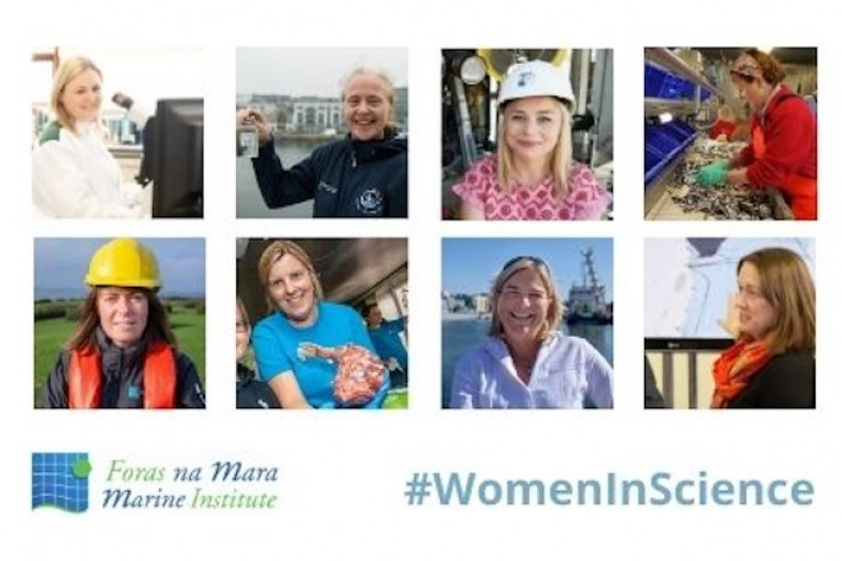
The Marine Institute is celebrating the International Day of Women and Girls in Science on 11th February 2021, by highlighting the many brilliant women who play transformative and ambitious roles in understanding, exploring, protecting and sustainably managing the wealth of our oceans.
"The Marine Institute recognises our people as a critical enabler of success, and we are committed to supporting a diverse workforce and a culture of high performance driven by our people. Just as the ocean supports a great diversity of life and ecosystems, the Marine Institute values our diverse workforce," said Patricia Orme, Director of Corporate Services at the Marine Institute.
The Marine Institute has a staff of 234 employees, and supports a strong workforce of female employees at 51%. The organisation continues to recognise that its employees’ skills, experience, diversity and passion for the marine are central to the work that is undertaken for the government and other partners.
"Almost 70% of the women working at the Marine Institute work in roles that deliver key services centred around science, technical analysis and research including areas of oceanography & ocean climate, fisheries ecosystems and advisory roles, marine environment and food safety and the development of applications. We also have women working in policy, innovation and research, maritime development and corporate roles. We are extremely proud to note that 80% of our female employees hold bachelor, masters or doctorate level qualifications," Patricia Orme added.
From the 8th – 12th February 2021, the Marine Institute will share photos, animations and profiles of female scientists, sharing their study and career paths, the work they do at the Marine Institute and the important contribution their work delivers. Follow #WomenInScience on the Marine Institute’s Facebook, Twitter and Instagram to meet some of our female scientists, learn about their work and their many successes.
The International Day of Women and Girls in Science Forum has been one of the flagship events of the United Nations, since its inception in 2016. It is a key event for women and girls in science, science experts, policy-makers and diplomats to share their vision, expertise and best practices to achieve internationally agreed development goals, including the 2030 Agenda for Sustainable Development. According to data from the UN Scientific Education and Cultural Organization (UNESCO), 30% of researchers worldwide are women and approximately 35% of all students in STEM-related fields in higher education are women.
Explorers Education Programme Launches ‘We Love the Ocean’ Facts to Inspire Fun Activities at Home

The Marine Institute’s Explorers Education Programme team are getting ready for the season of love by launching a series of fascinating facts about the ocean.
“Making personal connections and hearing stories about what we love to do at home and why we also love the ocean is a great way to help us all increase awareness of the ocean and inspire new conversations about why the ocean is important to us,” said Cushla Dromgool-Regan, Explorers Education manager.
“With these fun facts, we hope to inspire parents, teachers and children to think more about how the ocean impacts their lives and how they impact the ocean – sometimes indirectly through their day-to-day activities at home and at school.
“Throughout February, we would love to hear about these ocean love connections posted on our social media sites or shared with us by email #LovetheOcean.”
Adding a personal touch to the 28 ‘We Love the Ocean’ facts, Dromgool-Regan adds, the team around Ireland are sharing what they love to do and connecting these activities with some of the amazing facts about the ocean.
The facts and connections also provide useful ideas for teachers and parents to link the ocean to subjects that are covered on the primary school curriculum.
If you would like to see more of the Explorers’ Love the Ocean facts for ideas to develop activities at home or in class, follow the Explorers Education Programe on Facebook and Twitter.
Ireland’s New Marine Research Vessel to Honour Irish Explorer Tom Crean
Ireland’s new marine research vessel will be named the RV Tom Crean. Due to be completed in summer 2022, the new state-of-the-art multi-purpose marine research vessel will carry out a wide range of marine research activities, including vital fisheries, climate change-related research, seabed mapping and oceanography.
The new 52.8-metre modern research vessel, which will replace the 31 metre RV Celtic Voyager, has been commissioned with funding provided by the Department of Agriculture, Food and the Marine approved by the Government of Ireland.
As Afloat's Jehan Ashmore reported at the weekend, Ireland’s new marine research vessel will be named the RV Tom Crean, after the renowned seaman and explorer who undertook three major groundbreaking expeditions to the Antarctic in the early years of the 20th Century which sought to increase scientific knowledge and to explore unreached areas of the world, at that time.
 An illustration of Ireland’s new marine research vessel, RV Tom Crean, produced by Norwegian architects Skipsteknisk AS
Minister for Agriculture, Food and the Marine, Charlie McConalogue T.D. said, “I am delighted to announce the name of Ireland’s new marine research vessel is the ‘RV Tom Crean’, acknowledging the contribution of a legendary Irish Explorer. The new vessel will enable Ireland to undertake critical research work which will support many of the projects outlined in the Programme for Government including fisheries assessment, offshore renewable energy, marine spatial planning, marine protected areas and addressing the challenges of climate change.”
The new marine research vessel will provide year-round service for expanded fisheries surveys, seabed mapping, deep water surveys and support increased research in the Atlantic Ocean. The new vessel will enable 300 operational days at sea each year, and up to 3000 scientist days per year. The new vessel will also enable the Marine Institute to continue to lead and support scientific, high-quality surveys that contribute to Ireland’s position as a leader in marine science.
A native of Annascaul in Co Kerry, Crean volunteered for Robert Falcon Scott’s Discovery expedition in 1901 and for his Terra Nova expedition in 1910. During the Terra Nova expedition, Crean made an 18-hour solo journey in desperate conditions to save the life of a fellow crew member and was awarded the Albert Medal for his acts of heroism. In 1914, he joined Ernest Shackleton on the Endurance expedition and, again, he proved himself to be a much-trusted crew member and someone capable of great endurance and heroism.
Dr Paul Connolly, CEO of the Marine Institute said, “The decision to name Ireland’s new research vessel after Tom Crean honours his achievements and gives due recognition to an Irish explorer of international renown. The Institute greatly appreciates the support of the descendants of Tom Crean in this decision. This naming decision also reflects the values of the Marine Institute, the collaborative efforts and achievements of its staff, particularly the service provided by all staff who go to sea.”
Speaking on the announcement today, grand-daughter of Tom Crean, Aileen Crean O’Brien, on behalf of the family, said: “We welcome the decision by the Irish government and the Marine Institute to name their new marine research vessel after Tom Crean, of whom we as a family are very proud.”
Dr Connolly continued, “This new multi-purpose research vessel, the RV Tom Crean will greatly enhance Ireland’s capacity to undertake collaborative research and acquire the data and knowledge essential to managing our marine resources.”
The two Marine Institute research vessels currently in operation, the RV Celtic Explorer and RV Celtic Voyager, are among the most intensively used research vessels in the world.
The new vessel will replace the RV Celtic Voyager, which was Ireland’s first purpose-built research vessel and was commissioned in 1997. It has been vital in providing marine scientists, researchers and its crew members with many years of valued experience at sea, expanding and strengthening marine science in Ireland to help inform decisions affecting our oceans. It was joined by its 65-metre sister RV Celtic Explorer in 2003.
The construction of the new national research vessel continues on schedule in 2021 at a total build cost of €25 million, with the build process expected to be completed by summer 2022. Spanish shipyard Astilleros Armon Vigo S.A. was awarded the contract to build Ireland’s new state-of-the-art marine research vessel in 2019, following the completion of the design by Norwegian ship design consultants Skipsteknisk AS.
The new research vessel will be a modern, multipurpose, silent vessel, capable of operating in the Irish Exclusive Economic Zone (EEZ). The new vessel will be able to go to sea for at least 21 days at a time and will be designed to operate in harsh sea conditions. Based in Galway, the vessel will be used by the Marine Institute, other state agencies and universities to undertake fisheries research, oceanographic and environmental research, seabed mapping and other multidisciplinary surveys. It will also maintain and deploy weather buoys, observational infrastructure and our Remotely Operated Vehicle (ROV) Holland I.
It will be designed to incorporate the latest proven technologies to ensure that it operates as efficiently as possible, ensuring minimal fuel consumption and minimising the vessel’s environmental impact and carbon footprint.


 as lead helm, rounds the Fastnet Rock on the way to the overall win in 1987")


 Michael Murphy Schull Harbour Sailing Club (SHSC), Eric Coogan Heineken Ireland, Mark Murphy, Commodore SHSC, Jack Allen SHSC, Carmel O'Regan SHSC, Cornelious Ndlovu, Schull Harbour Hotel Operations Manager and Derval Murphy SHSC")
