Menu

Ireland's sailing, boating & maritime magazine

Inland afloat headers


Displaying items by tag: Climate Change

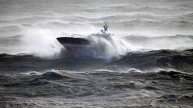
#RisingSeaLevels - Rising sea levels around Ireland due to climate change are almost 7cm since the early 1990s.

The Irish Examiner writes that this is due to the rising temperature of the planet, greenhouse gas emissions (GHGs) and the melting of glaciers.

And the next five to 15 years is a crucial time period within which to act if we want to halt any permanent changes to the planet.

According to the Environmental Protection Agency (EPA), climate change is most obvious in our changing sea levels.

The newspaper also writes that the number of high quality rivers has halved.

“Observed climate change impacts are most evident in the global temperature record, sea-level rise, loss of glaciers and ice sheets and changes in the nature and intensification of precipitation events,” the EPA report states.

“Since 1993, average sea level has risen around Ireland by just over 3cm per decade,” the report reads.

For further coverage the newspaper has more here 

Published in Weather

#MarineScience - Applications are invited from postgraduate students of marine science, atmosphere and climate-based sciences worldwide to participate in the Atlantic Ocean Climate Scholars Programme in Galway from 12-20 September 2016.

This intensive, accredited workshop will examine how climate and oceans interact, with particular examples from the Atlantic Ocean and higher latitudes.

The programme will be led by an international team of research leaders in climate science with contributions from policy makers and researchers in the field.

A number of scholarships are available to cover travel and accommodation expenses and the deadline for applications is this Friday 3 June 2016.

The relationships between human activities and the oceanic and atmospheric processes that drive our climate will be investigated in the context of the latest IPCC Assessment Report published in 2013.

Critical elements of the global climate system will be scrutinised with special reference to the Atlantic Ocean and its ecosystems. Ocean observation programmes, new technologies, and model outputs will be evaluated in the context of societal and governmental responses to climate change.

Workshop activities will include presentations, field trips and practical data sessions.

Applicants can apply online until 1800 UTC on Friday 3 June. Further information is available by emailing [email protected] or [email protected].

The Atlantic Ocean Climate Scholars Programme is a collaboration between the Strategic Marine Alliance for Research & Training (SMART) based in GMIT, NUI Galway, the Alfred Wegener Institute (AWI), the Partnership for the Observation of the Global Ocean (POGO), the Helmholtz Climate Programme REKLIM and is supported by the Nippon Foundation.

Published in Marine Science

#ClimateChange - Models to predict the future climate indicate that global temperatures will rise by an average of as much as 4.5C by the end of this century, bringing a rise in sea levels and changes to rainfall patterns.

And these changes in the weather are already being felt in Ireland, according to Met Éireann's head of climatology Séamus Walsh, who says that even slight shifts, such as an increase in the number of warm days over 20C, have "a knock-on effect on natural ecosystems" that have adapted to Ireland's climate.

"Fragile habitats in vulnerable upland, peatland and coastal areas will come under increasing stress," he adds, noting also a 5% increase in rainfall over the last three decades, more so in the West and North West.

"Climate projections for rainfall have greater uncertainty than for temperature," he explains. "They indicate that overall rainfall amounts in Ireland might decrease slightly, summers are likely to become drier while winters may be wetter, especially in the west and north."

There are also indications of an increase in the number of very wet days – days with rainfall over 20mm – which means that such projections, when applies to river flows, show "an increased risk of winter flooding, an increased risk of short duration ‘flash’ floods and to possible water shortages in summer months due to higher temperatures and lower rainfall.

"The rise in sea levels will make low lying coastal areas more prone to flooding, especially from storm surges," he adds.

Met Éireann has more on the story HERE.
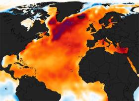
Published in Weather

#MarineScience - Climate change is rapidly warming lakes around the world, threatening freshwater supplies and ecosystems, according to a new study spanning six continents.

More than 60 scientists took part in the research, published in the journal Geophysical Research Letters and announced at the fall meeting of the American Geophysical Union on Wednesday 16 December.

The study – based on global analyses including unique long-term data from the Marine Institute's catchment research facility at Newport, Co Mayo – found that lakes are warming an average of 0.34C, or 0.61F, each decade.

That's greater than the warming rate of either the oceans or the atmosphere, and it can have profound effects, the scientists say.

At the current rate, algal blooms – which can ultimately rob water of oxygen – are projected to increase 20 percent in lakes over the next century. Algal blooms that are toxic to fish and animals would increase by five percent.

These rates imply that emissions of methane, a greenhouse gas 25 times more powerful than carbon dioxide, will increase four percent over the next decade.

"Lakes are important because society depends on surface water for the vast majority of human uses," said co-author Stephanie Hampton, director of Washington State University's Center for Environmental Research, Education and Outreach.

"Not just for drinking water, but manufacturing, for energy production, and for irrigation of our crops. Protein from freshwater fish is especially important in the developing world."

Temperature is one of the most fundamental and critical physical properties of water. It controls a host of other properties that include intricate living processes that have evolved within strict boundaries.

When the temperature swings quickly and widely from the norm, life forms in a lake can change dramatically and even disappear.

"These results suggest that large changes in our lakes are not only unavoidable, but are probably already happening," said lead author Catherine O'Reilly, associate professor of geology at Illinois State University.

Earlier research by O'Reilly has seen declining productivity in lakes with rising temperatures.

Funded in part by NASA and the National Science Foundation, the study is the largest of its kind and the first to use a combination of long-term hand measurements and temperature measurements made from satellites, offsetting the shortcomings of each method.

Study co-author Simon Hook, science division manager at the NASA Jet Propulsion Laboratory, said satellite measurements provide a broad view of lake temperatures over the entire globe. But they only measure surface temperature, while hand measurements can detect changes in temperature throughout a lake. Also, satellite measurements go back only 30 years while some lake measurements can go back more than a century.

Lough Feeagh in Co Mayo was one of 235 lakes in the study that have been monitored for at least 25 years. While that's a fraction of the world's lakes, they contain more than half the world's freshwater supply.

The Marine Institute measures the surface water temperature of Lough Feeagh as part of the long term ecological monitoring of the Burrishoole catchment. The Burrishoole research station is an internationally important index site for diadromous fish monitoring, and water temperature is a crucial variable controlling growth, migration and survival of salmon, trout and eel in the catchment.

"The inclusion of data from Lough Feeagh in this study highlights the value of collecting local environmental long term data to inform global analyses," said Dr Elvira de Eyto, a biologist at the Marine Institute facility in Burrishoole and one of the studies co-authors.

Marine Institute chief executive Dr Peter Heffernan added: "The sharing of such data with global scientific networks makes an important contribution to worldwide climate change analyses, and our understanding of how the warming climate will affect our valuable aquatic resources."

The surface water of Lough Feeagh has warmed at a rate of 0.35C per decade between 1985-2009, although the rate of warming was lower than some other northern hemisphere lakes.

"We want to be careful that we don't dismiss some of these lower rates of change," said Hampton. "In warmer lakes, those temperature changes can be really important. They can be just as important as a higher rate of change in a cooler lake."

The researchers said various climate factors are associated with the warming trend. In northern climates lakes are losing their ice cover earlier, and many areas of the world have less cloud cover, exposing their waters more to the sun's warming rays.

Many lake temperatures are rising faster than the average air temperatures. Some of the greatest warming is seen at northern latitudes, where rates can average 0.72C, or 1.3F, per decade.

Warm-water, tropical lakes may be seeing less dramatic temperature increases, but increased warming of these lakes can still have large negative impacts on fish. That can be particularly important in the African Great Lakes, home to one-fourth of the planet's freshwater supply and an important source of fish for food.

In general, the researchers write: "The pervasive and rapid warming observed here signals the urgent need to incorporate climate impacts into vulnerability assessments and adaptation efforts for lakes."

Published in Marine Science

Bray, Co Wicklow was the location for a unique Climate Change event on Friday (20th November) hosted by Seán Kelly MEP on the importance of achieving a global deal to reduce carbon emissions in Paris next month.

"I am honoured to have been chosen to be part of the delegation that will represent the European Parliament at the global UN Climate Change Conference in Paris in December and will be the only Irish MEP to do so. We received our mandate with a huge majority from the Parliament last month and we are ready to work in Paris to get our key points across," Mr Kelly told attendees.

"Climate Change is truly one of the key challenges of this century. Failure to address it effectively will result in major adverse impacts that will affect all countries.

"Ireland, for example, is particularly vulnerable to loss of coastal assets due to rising sea levels, along with increased precipitation and the resulting flood risks - all of these would prove hugely costly, both socially and economically.

"The bottom line is, we need an ambitious and binding global agreement and we will push for that in Paris. If EU ambition is matched globally, we keep jobs and economic growth here, while meeting the 2oC objective," the MEP added.

Climate change is a cross sector challenge according to Mr Kelly which requires a concerted global effort. "We need to take action to limit these temperature increases, but we have a challenge to do so while meeting the parallel challenges of ensuring food security and maintaining EU competitiveness."

"The bottom line is, we need an ambitious and binding global agreement and we will push for that in Paris. If EU ambition is matched globally, we keep jobs and economic growth here, while meeting the 2oC objective," he said.

Event speakers included Jean-Pierre Thebault, French Ambassador to Ireland, Eamon Ryan, Leader of the Green Party, Mauro Poinelli, Head of Unit Environment, Forestry and Climate Change, European Commission, who examined the agricultural side of the debate and Neil Walker, IBEC’s Head of Infrastructure, Energy and Environment who presented the Irish business perspective.

Published in Coastal Notes
Tagged under

#MarineWildlife - Climate change is driving fish species away from the tropics for more hospitable, warming waters elsewhere, according to scientists from the University of British Columbia.

RTÉ News has more on the story, which outlines that even in the best case scenario, the waters of the tropics are set to warm by one degree Celsius, promoting fish to migrate some 15 kilometres every decade towards the Arctic and Antarctic.

The Canadian university researchers used climate modelling based on findings from the past few decades to predict the situation for more than 800 fish species and marine invertebrates – and the results could be catastrophic for all coastal communities as the ecosystem changes.

Published in Marine Wildlife

#MarineWildlife - "What if whales were nature's ultimate geoengineers?" That's the question Philip Hoare poses on the Guardian's Comment Is Free section upon the news that US scientists have identified cetacean waste as a potentially pivotal link in the climate change chain.

Marine scientists from the University of Vermont compiled decades' worth of research in their new report that claims whale faeces – and deceased whales on the ocean floor – might comprise "massive carbon sinks" absorbing the CO2 human industry puts into the environment while also providing nutrients for other marine wildlife.

Indeed, it's now thought that areas where cetacean populations have shown signs of recovery after decades of hunting are also seeing "higher rates of productivity" among commercial fishing species.

The new report also supports the notion that climate change "may have been accelerated by the terrible whale culls of the 20th century" that removed a necessary balancing effect to counter the huge levels of man-made carbon emissions.

As Hoare writes: "A burgeoning global population of cetaceans might not just be good for the whalewatching industry, they may play a significant role in the planet's rearguard action against climate change."

The Guardian has much more on the story HERE.

Published in Marine Wildlife

#Jellyfish - Jellyfish are coming to Ireland's shores in bigger numbers than ever before, as the Belfast Telegraph reports.

The "worrying" finding comes with the latest figures of the annual Coastwatch survey of the island of Ireland that concluded in mid October.

Stats collected from volunteers around the coast show that jellyfish have been sighted in more areas and in greater numbers than any other time in the 25-year history of the survey - most likely the result of climate change.

Among them was an "absolutely enormous" specimen more 5 feet in diameter, found on the West coast.

"What this says to us is that our waters are warming," said Coastwatch International co-ordinator Karin Dubsky, who highlighted an explosion in the numbers of small brown jellyfish "which do a lot of damage to wildlife".

The Belfast Telegraph has more on the story HERE.

Published in Marine Wildlife
Tagged under

#POWER FROM THE SEA - Marine-based renewable energy projects could be introduced without a damaging impact on marine wildlife, according to a new briefing paper from Friends of the Earth.

Business Green reports on the paper from the environmental campaign group, written by marine ecologist Martin Attrill of Plymouth University's Marine Institute, which draws together research on the biodiversity impact of offshore wave energy, tidal energy and wind power schemes.

Attrill found that the deployment of sea energy arrays could ultimately benefit many marine species by reducing the effects of fishing activity, and even acting as reefs to attract new sea life.

He cites the example of a grey seal colony in Strangford Lough that has steered clear of a nearby tidal turbine over the three years of its operation in the lough.

However, Business Green says the report makes clear that the deployment of such projects "must be done sensitively", noting that any negative impact on biodiversity "would be significantly lower than the damage done to marine wildlife by rising sea levels caused by climate change".

Business Green has more on the story HERE.

Published in Power From the Sea
Brendan Smith TD, Minister for Agriculture, Fisheries and Food visited (Saturday 2nd Oct) the Marine Institute laboratories in Co. Mayo to see at first hand the important work being carried out by the Institute in collaboration with UCD and Trinity College on the impacts of climate change. This work has been developed as part of the NDP funded RESCALE project (Review and Simulate Climate and Catchment Responses at Burrishoole) and involves the development of computer models to assist land use and fisheries managers to deal with impacts of climate change on sensitive peatland river catchments. In an Irish context this is the first time that Global Climate Models have been downscaled to a catchment scale and the work has clearly shown that in addition to milder winters and warmer summers we can also expect more frequent flood events in the west of Ireland by the 2080's. Inland Waterways

Launching the publication of the final report on RESCALE project, Minister Smith said that the project was a major milestone in our understanding of the effects of climate change on sensitive upland catchments in the west of Ireland. "While global climate change is a worldwide phenomenon, the research findings in this report provide information at the local level that will be invaluable to fisheries and land use managers," said the Minister. "Practical research work such as RESCALE is essential if we are to plan for the future management of our valuable agriculture, fisheries and forestry resources in the west of Ireland."

The project is studying data from an unbroken record of information on water temperature, air temperature, river discharge, rainfall and a host of other factors which exists for the catchment dating back to the 1950s for the Burrishoole river. This information collected at the Furnace facility and the neighbouring Met Eireann synoptic station, is invaluable as a resource, not only for measuring physical change over the past sixty years, but also as a proven yardstick to "ground-truth" any computer-generated models describing the likely effects of global warming. Minister Smith said "I am very impressed with the work being done here in Newport and the high level of collaboration between the Institute and the Universities on marine research and its practical application to real situations to help inform decision making into the future."

Published in Inland Waterways
Page 7 of 8

General Information on using Waterways Ireland inland navigations

Safety on the Water

All users of the navigations are strongly recommended to make themselves aware of safety on the water for whatever activity they are involved in and to read the advice offered by the various governing bodies and by:

The Dept. of Transport, Ireland: www.gov.ie/transport and The Maritime and Coastguard Agency, UK, The RNLI – Water Safety Ireland for information in terms of drowning prevention and water safety.

Registration of Vessels

All vessels using the Shannon Navigation, which includes the Shannon-Erne Waterways and the Erne System must be registered with Waterways Ireland. Only open undecked boats with an engine of 15 horsepower or less on the Shannon Navigation, and vessels of 10 horsepower or less on the Erne System, are exempt. Registration is free of charge.

Craft registration should be completed online at: https://www.waterwaysireland.org/online-services/craft-registration

Permits for use of the Grand and Royal Canals and the Barrow Navigation

All vessels using the Grand and Royal Canals and the Barrow Navigation must display appropriate valid Permit(s) i.e A Combined Mooring and Passage Permit (€126) and if not intending to move every five days, an Extended Mooring Permit (€152).

Permit applications should be completed online at: https://www.waterwaysireland.org/online-services/canal-permits

Passage on the Royal and Grand Canals – Dublin Area

For boat passage through the locks east of Lock 12 into / out of Dublin on either the Royal or Grand Canals, Masters are requested to contact the Waterways Ireland Eastern Regional Office (M-F 9.30am-4.30pm) on tel: +353(0)1 868 0148 or email [email protected] prior to making passage in order to plan the necessary lock-keeping assistance arrangements.

On the Grand Canal a minimum of two days notice prior to the planned passage should be given, masters should note that with the exception of pre-arranged events, a maximum of 2 boats per day will be taken through the locks, travelling either east or west.

Movements in or out of the city will be organised by prior arrangement to take place as a single movement in one day. Boaters will be facilitated to travel the system if their passage is considered to be safe by Waterways Ireland and they have the valid permit(s) for mooring and passage.

Newcomen Lifting Bridge

On the Royal Canal two weeks’ notice of bridge passage (Newcomen Lifting Bridge) is required for the pre-set lift date, and lock assistance will then also be arranged. A minimum of 2 boats is required for a bridge lift to go ahead.

Waterways Ireland Eastern Regional Office (Tel: +353(0)1 868 0148 or [email protected] ) is the point of contact for the bridge lift.

A maximum number of boats passing will be implemented to keep to the times given above for the planned lifts (16 for the Sat / Sun lifts & 8 for the weekday lifts). Priority will be given on a first come first served basis.

On day of lift, boaters and passengers must follow guidance from Waterways Ireland staff about sequence of passage under bridge & through Lock 1, and must remain within signed and designated areas.

Events Held on the Waterways

All organised events taking place on the waterways must have the prior approval of Waterways Ireland. This is a twelve week process and application forms must be accompanied with the appropriate insurance, signed indemnity and risk assessment. The application should be completed on the Waterways Ireland events page at :

https://www.waterwaysireland.org/online-services/event-approval

Time Limits on Mooring in Public Harbours

On the Shannon Navigation and the Shannon-Erne Waterway craft may berth in public harbours for five consecutive days or a total of seven days in any one month.

On the Erne System, revised Bye Laws state that: No master or owner shall permit a vessel, boat or any floating or sunken object to remain moored at or in the vicinity of any public mooring, including mooring at any other public mooring within 3 kilometres of that location, for more than 3 consecutive days and shall not moor at that same mooring or any other public mooring within 3 kilometres of that location within the following 3 consecutive days without prior permission by an authorised official.

Winter Mooring on the Shannon Navigation and Shannon Erne Waterway

Winter mooring may be availed of by owners during the period 1 Nov to 31 Mar by prior arrangement and payment of a charge of €63.50 per craft. Craft not availing of Winter Mooring must continue to comply with the “5 Day Rule”. Winter Mooring applications should be completed online at : https://www.waterwaysireland.org/online-services/winter-moorings-booking

Owners should be aware that electricity supply and water supply to public moorings is disconnected for the winter months. This is to protect against frost damage, to reduce running costs and to minimise maintenance requirements during the winter months.

Vessel owners are advised that advance purchasing of electricity on the power bollards leading up to the disconnection date should be minimal. Electricity credit existing on the bollards will not be recoverable after the winter decommissioning date. Both services will be reinstated prior to the commencement of the next boating season.

Smart Cards

Waterways Ireland smart cards are used to operate locks on the Shannon Erne Waterway, to access the service blocks, to use the pump-outs along the navigations, to avail of electrical power at Waterways Ireland jetties.

Berthing in Public Harbours

Masters are reminded of the following:

  • Equip their vessel with mooring lines of appropriate length and strength and only secure their craft to mooring bollards and cleats provided for this purpose.
  • Ensure the available berth is suitable to the length of your vessel, do not overhang the mooring especially on finger moorings on floating pontoon moorings.
  • Ensure mooring lines, electric cables and fresh water hoses do not create a trip hazard on public jetties for others users.
  • Carry sufficient fenders to prevent damage to your own vessel, other vessels and WI property.
  • Allow sufficient space between your vessel and the vessel ahead /astern (c.1m) for fire safety purposes and /or to recover somebody from the water.
  • Do not berth more than two vessels side by side and ensure there is safe access/egress at all times between vessels and onto the harbour itself.
  • Do not berth in such a way to prevent use of harbour safety ladders, slipways or pump-outs.
  • Do not allow the bow of your vessel to overhang the walkway of a floating mooring thus creating a hazard for others with an overhanging anchor or bow fendering.
  • Animals are not allowed to be loose or stray at any time.
  • Harbour and jetty infrastructure such as railings, power pedestals, fresh water taps, electric light poles, safety bollards, ladders etc are not designed for the purpose of mooring craft , they will not bear the strain of a vessel and will be damaged.
  • At Carrybridge on the Erne System, Masters of vessels are not permitted to use stern on mooring. Masters of vessels must use the mooring fingers for mooring of vessels and for embarkation / disembarkation from vessels.

Passenger Vessel Berths

Masters of vessels should not berth on passenger vessel berths where it is indicated that an arrival is imminent. Passenger vessels plying the navigations generally only occupy the berths to embark and disembark passengers and rarely remain on the berths for extended periods or overnight.

Lock Lead-in Jetties

Lead-in jetties adjacent to the upstream and downstream gates at lock chambers are solely for the purpose of craft waiting to use the lock and should not be used for long term berthing.

Vessel Wake

Vessel wake, that is, the wave generated by the passage of the boat through the water, can sometimes be large, powerful and destructive depending on the hull shape and engine power of the vessel. This wake can be detrimental to other users of the navigation when it strikes their craft or inundates the shoreline or riverbank. Masters are requested to frequently look behind and check the effect of their wake / wash particularly when passing moored vessels, on entering harbours and approaching jetties and to be aware of people pursuing other activities such as fishing on the riverbank.

Speed Restriction

A vessel or boat shall not be navigated on the Shannon Navigation at a speed in excess of 5 kph when within 200 metres of a bridge, quay, jetty or wharf, when in a harbour or canal or when passing within 100 metres of a moored vessel or boat.

Vessels navigating the Shannon-Erne Waterway should observe the general 5 kph speed limit which applies along the waterway. This is necessary in order to prevent damage to the banks caused by excessive wash from vessels.

Vessels navigating the Erne System should observe the statutory 5kt / 6mph / 10kph speed limit areas.

A craft on the Royal and Grand canals shall not be navigated at a speed in excess of 6km per hour.

A craft on the Barrow Navigation shall not be navigated at a speed in excess of 11km per hour except as necessary for safe navigation in conditions of fast flow.

Bank Erosion

Narrow sections of all the navigations are particularly prone to bank erosion due to the large wash generated by some craft. Masters are requested to be vigilant and to slow down to a speed sufficient to maintain steerage when they observe the wash of their craft inundating the river banks.

Unusual Waterborne Activity

Unusual waterborne vessels may be encountered from time to time, such as, hovercraft or amphibious aircraft / seaplanes. Masters of such craft are reminded to apply the normal “Rule of the Road” when they meet conventional craft on the water and to allow extra room to manoeuvre in the interest of safety.

Sailing Activity

Mariners will encounter large numbers of sailing dinghies from late June to August in the vicinity of Lough Derg, Lough Ree and Lower Lough Erne. Sailing courses are marked by yellow buoys to suit weather conditions on the day. Vessels should proceed at slow speed and with due caution and observe the rules of navigation when passing these fleets, as many of the participants are junior sailors under training.

Rowing

Mariners should expect to meet canoes and vessels under oars on any part of the navigations, but more so in the vicinity of Athlone, Carrick-on-Shannon, Coleraine, Enniskillen and Limerick. Masters are reminded to proceed at slow speed and especially to reduce their wash to a minimum when passing these craft as they can be easily upset and swamped due to their very low freeboard and always be prepared to give way in any given traffic situation.

Canoeing

Canoeing is an adventure sport and participants are strongly recommended to seek the advice of the sport’s governing bodies i.e Canoeing Ireland and the Canoe Association of Northern Ireland, before venturing onto the navigations.

Persons in charge of canoes are reminded of the inherent danger to these craft associated with operating close to weirs, sluice gates, locks and other infrastructure particularly when rivers are in flood and large volumes of water are moving through the navigations due to general flood conditions or very heavy localised precipitation e.g. turbulent and broken water, stopper waves. Shooting weirs is prohibited without prior permission of Waterways Ireland.

Canoeists should check with lockkeepers prior entering a lock to ensure passage is done in a safe manner. Portage is required at all unmanned locks.

Canoe Trail Network – "Blueways"

Masters of powered craft are reminded that a canoe trail network is being developed across all navigations and to expect more organised canoeing along these trails necessitating slow speed and minimum wash when encountering canoeists, rowing boats etc

Rockingham and Drummans Island Canals – Lough Key

It is expected that work on Rockingham and Drummans Island Canals on Lough Key will be completed in 2021. Access to these canals will be for non-powered craft only, eg canoes, kayaks, rowing boats.

Fast Powerboats and Personal Watercraft (Jet Skis)

Masters of Fast Powerboats (speed greater than 17kts) and Personal Watercraft (i.e.Jet Skis) are reminded of the inherent dangers associated with high speed on the water and especially in the confines of small bays and narrow sections of the navigations. Keeping a proper look-out, making early alterations to course and /or reducing speed will avoid conflict with slower vessels using the navigation. Personal Watercraft are not permitted to be used on the canals.

Towing Waterskiers, Wakeboarders, Doughnuts etc

Masters of vessels engaged in any of these activities are reminded of the manoeuvring constraints imposed upon their vessel by the tow and of the added responsibilities that they have to the person(s) being towed. These activities should be conducted in areas which are clear of conflicting traffic. It is highly recommended that a person additional to the master be carried to act as a “look-out” to keep the tow under observation at all times.

Prohibition on Swimming

Swimming in the navigable channel, particularly at bridges, is dangerous and is prohibited due to the risk of being run over by a vessel underway in the navigation.

Age Restrictions on operating of powered craft

In the Republic of Ireland, Statutory Instrument 921 of 2005 provides the legal requirements regarding the minimum age for operating of powered craft. The Statutory Instrument contains the following requirements:

- The master or owner of a personal watercraft or a fast power craft shall take all reasonable steps to ensure that a person who has not attained the age of 16 years does not operate or control the craft

- The master or owner of a pleasure craft powered by an engine with a rating of more than 5 horse power or 3.7 kilowatts shall take all reasonable steps to ensure that a person who has not attained the age of 12 years does not operate or control the craft.

Lifejackets and Personal Flotation Devices (PFDs)

Lifejackets and PFD’s are the single most important items of personal protective equipment to be used on a vessel and should be worn especially when the vessel is being manoeuvred such as entering / departing a lock, anchoring, coming alongside or departing a jetty or quayside.

In the Republic of Ireland, Statutory Instrument 921 of 2005 provides the legal requirements regarding the wearing of Personal Flotation Devices. The Statutory Instrument contains the following requirements:

- The master or owner of a pleasure craft (other than a personal watercraft) shall ensure, that there are, at all times on board the craft, sufficient suitable personal flotation devices for each person on board.

- A person on a pleasure craft (other than a personal watercraft) of less than 7 metres length overall shall wear a suitable personal flotation device while on board an open craft or while on the deck of decked craft, other than when the craft is made fast to the shore or at anchor.

- The master or owner of a pleasure craft (other than a personal watercraft) shall take all reasonable steps to ensure that a person who has not attained the age of 16 years complies with paragraph above.

- The master or owner of a pleasure craft (other than a personal watercraft), shall take all reasonable steps to ensure that a person who has not attained the age of 16 years wears a suitable personal flotation device while on board an open craft or while on the deck of a decked craft other than when it is made fast to the shore or at anchor.

- The master or owner of a pleasure craft (other than a personal watercraft) shall take all reasonable steps to ensure that a person wears a suitable personal flotation device, at all times while – (a) being towed by the craft, (b) on board a vessel or object of any kind which is being towed by the craft.

Further information is available at: http://www.irishstatutebook.ie/eli/2005/si/921/made/en/print

Firing Range Danger Area – Lough Ree

The attention of mariners is drawn to the Irish Defence Forces Firing Range situated in the vicinity of buoys No’s 2 and 3, on Lough Ree on the Shannon Navigation. This range is used regularly for live firing exercises, throughout the year, all boats and vessels should stay clear of the area marked with yellow buoys showing a yellow "X" topmark and displaying the word "Danger".

Shannon Navigation, Portumna Swing Bridge Tolls

No attempt should be made by Masters’ of vessels to pay the bridge toll while making way through the bridge opening. Payment will only be taken by the Collector from Masters when they are secured alongside the jetties north and south of the bridge.

Navigating from Killaloe to Limerick on the Shannon Navigation

The navigation from Killaloe to Limerick involves passage through Ardnacrusha locks, the associated headrace and tailrace and the Abbey River into Limerick City. Careful passage planning is required to undertake this voyage. Considerations include: lock passage at Ardnacrusha, water flow in the navigation, airdraft under bridges on Abbey River in Limerick, state of tide in Limerick

Users are advised to contact the ESB Ardnacrusha hydroelectric power station (00353 (0)87 9970131) 48 hours in advance of commencing their journey to book passage through the locks at Ardnacrusha. It is NOT advised to undertake a voyage if more than one turbine is operating (20MW), due to the increased velocity of flow in the navigation channel, which can be dangerous. To ascertain automatically in real time how many turbines are running, users can phone +353 (0)87 6477229.

For safety reasons the ESB has advised that only powered craft with a capacity in excess of 5 knots are allowed to enter Ardnacrusha Headrace and Tailrace Canals.

Passage through Sarsfield Lock should be booked on +353-87-7972998, on the day prior to travel and it should be noted also that transit is not possible two hours either side of low water.

A Hydrographic survey in 2020 of the navigation channel revealed that the approach from Shannon Bridge to Sarsfield Lock and the Dock area has silted up. Masters of vessels and water users are advised to navigate to the Lock from Shannon bridge on a rising tide one or two hours before High Tide.

Lower Bann Navigation

The attention of all users is drawn to the “Users Code for the Lower Bann”, in particular to that section covering “Flow in the River” outlining the dangers for users both on the banks and in the navigation, associated with high flow rates when the river is in spate. Canoeists should consult and carry a copy of the “Lower Bann Canoe Trail” guide issued by the Canoe Association of Northern Ireland. Users should also contact the DfI Rivers Coleraine, who is responsible for regulating the flow rates on the river, for advisory information on the flow rates to be expected on any given day.

DfI Rivers Coleraine. Tel: 0044 28 7034 2357 Email: [email protected]

Lower Bann Navigation – Newferry – No wake zone

A No Wake Zone exists on the Lower Bann Navigation at Newferry. Masters of vessels are requested to proceed at a slow speed and create no wake while passing the jetties and slipways at Newferry.

Overhead Power Lines (OHPL) and Air draft

All Masters must be aware of the dangers associated with overhead power lines, in particular sailing vessels and workboats with cranes or large air drafts. Voyage planning is a necessity in order to identify the location of overhead lines crossing the navigation.

Overhead power line heights on the River Shannon are maintained at 12.6metres (40 feet) from Normal Summer level for that section of navigation, masters of vessels with a large air draft should proceed with caution and make additional allowances when water levels are high.

If a vessel or its equipment comes into contact with an OHPL the operator should NOT attempt to move the vessel or equipment. The conductor may still be alive or re-energise automatically. Maintain a safe distance and prevent third parties from approaching due to risk of arcing. Contact the emergency services for assistance.

Anglers are also reminded that a minimum ground distance of 30 metres should be maintained from overhead power lines when using a rod and line.

Submarine Cables and Pipes

Masters of vessels are reminded not to anchor their vessels in the vicinity of submarine cables or pipes in case they foul their anchor or damage the cables or pipes. Look to the river banks for signage indicating their presence.

Water Levels - Precautions

Low Water Levels:

When water levels fall below normal summer levels masters should be aware of:

Navigation

To reduce the risk of grounding masters should navigate on or near the centreline of the channel, avoid short cutting in dog-legged channels and navigating too close to navigation markers.

Proceeding at a slow speed will also reduce “squat” effect i.e. where the vessel tends to sit lower in the water as a consequence of higher speed.

Slipways

Reduced slipway length available under the water surface and the possibility of launching trailers dropping off the end of the concrete apron.

More slipway surface susceptible to weed growth requiring care while engaged in launching boats, from slipping and sliding on the slope. Note also that launching vehicles may not be able to get sufficient traction on the slipway once the craft is launched to get up the incline.

Bank Erosion

Very dry riverbanks are more susceptible to erosion from vessel wash.

Lock Share

Maximising on the number of vessels in a lock will ensure that the total volume of water moving downstream is decreased. Lock cycles should be used for vessels travelling each way.

High Water Levels:

When water levels rise above normal summer level masters should be aware of:

Navigation

Navigation marks will have reduced height above the water level or may disappear underwater altogether making the navigable channel difficult to discern.

In narrow sections of the navigations water levels will tend to rise more quickly than in main streams and air draft at bridges will likewise be reduced.

There will also be increased flow rates particularly in the vicinity of navigation infrastructure such as bridges, weirs, locks etc where extra care in manoeuvring vessels will be required.

Harbours and Jetties

Due care is required in harbours and at slipways when levels are at or near the same level as the harbour walkways' as the edge will be difficult to discern especially in reduced light conditions. It is advised that Personal Flotation Devices be worn if tending to craft in a harbour in these conditions.

Slipways

Slipways should only be used for the purpose of launching and recovering of water craft or other objects from the water. Before using a slipway it should be examined to ensure that the surface has sufficient traction/grip for the intended purpose such as launching a craft from a trailer using a vehicle, that there is sufficient depth of water on the slipway to float the craft off the trailer before the concrete apron ends and that the wheels of the trailer do not drop off the edge of the slipway. That life-saving appliances are available in the vicinity, that the vehicle is roadworthy and capable of coping with the weight of the trailer and boat on the incline. It is recommended that slipway operations are conducted by two persons.

Caution to be Used in Reliance upon Aids to Navigation

The aids to navigation depicted on the navigation guides comprise a system of fixed and floating aids to navigation. Prudent mariners will not rely solely on any single aid to navigation, particularly a floating aid to navigation. With respect to buoys, the buoy symbol is used to indicate the approximate position of the buoy body and the ground tackle which secures it to the lake or river bed. The approximate position is used because of the practical limitations in positioning and maintaining buoys in precise geographical locations. These limitations include, but are not limited to, prevailing atmospheric and lake/river conditions, the slope of and the material making up the lake/river bed, the fact that the buoys are moored to varying lengths of chain, and the fact that the buoy body and/or ground tackle positions are not under continuous surveillance. Due to the forces of nature, the position of the buoy body can be expected to shift inside and outside the charted symbol.

Buoys and perches are also moved out of position or pulled over by those mariners who use them to moor up to instead of anchoring. To this end, mariners should always monitor their passage by relating buoy/perch positions with the published navigation guide. Furthermore, a vessel attempting to pass close by always risks collision with a yawing buoy or with the obstruction that the buoy or beacon/perch marks.

Masters of Vessels are requested to use the most up to date Navigation guides when navigating on the Inland Waterways.

Information taken from Special Marine Notice No 1 of 2023