


Displaying items by tag: Marine Notice
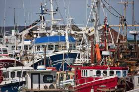
Marine Notice: Annual Monkfish & Megrim Survey
#MarineNotice - The latest Marine Notice from the Department of Transport, Tourism and Sport (DTTAS) advises that the Marine Institute is carrying out its annual Irish anglerfish and megrim survey (IAMS 2017) in fulfilment of Ireland’s Common Fisheries Policy obligations from this Tuesday 14 February to Friday 17 March.
The IAMS is a demersal trawl and beam trawl survey consisting of around 85 otter trawls (60 minutes) and 25 beam trawls (30 minutes) in International Council for Exploration of the Sea (ICES) area 7b, 7c, 7g, 7h, 7j and 7k off the West, South West and South Coasts.
Fishing in 2017 will take place within a three-nautical-mile radius of the positions indicated in Marine Notice No 5 of 2017, a PDF of which is available to read or download HERE.
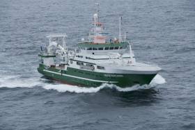
The survey will be conducted by the RV Celtic Explorer (Callsign EIGB), which will display all appropriate lights and signals during the survey and will also be listening on VHF Channel 16.
The vessel will be towing a Jackson demersal trawl or two 4m beam trawls during operations. The Marine Institute requests that commercial fishing and other marine operators to keep a 3nm area around the tow points clear of any gear or apparatus during the survey period outlined above.
While there is no statutory provision for the loss of gear at sea, the Marine Institute will make every effort to avoid gear adequately marked according to legislation that may be encountered in the notified areas.
In the event that an operator has static gear or other obstructions within 3nm of the points listed, it is the responsibility of the owner to notify the survey managers or vessel directly.
This should be communicated by identifying specifically which ‘station’ is of concern using the appendix and contact details provided in the Marine Notice. It is not required to provide positional details of commercial operations beyond 4nm of the survey points provided.
Specifics of any fishing gear or other obstructions that are known and cannot be kept clear of these survey haul locations can be notified using the contact details provided.
Marine Notice: Rossaveal Fishery Harbour Works Continue
#MarineNotice - Marine Notice No 4 of 2017 advises of the continued drilling and blasting of bedrock, construction of breakwater and resentment, installation of piles and pontoons and other associated works at Rossaveal Fishery Harbour Centre.
As previously reported on Afloat.ie, the works commenced on Monday 22 August last with a view to completion in January, but will now continue till July.
All previously notified dumping activities have finished. Drilling and blasting of bedrock, installation of piles, and installation of pontoons is ongoing. These works are
being carried out from causeways, a jack-up barge and work boats.
All vessels will be listening on VHF Channel 16 throughout the project.
Marine Notice: Hi-Line Protocols For Helicopter SAR Assistance
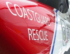
#MarineNotice - The latest Marine Notice from the Department of Transport, Tourism and Sport (DTTAS) details the proper hi-line protocols when receiving assistance from a search and rescue helicopter.
The notice follows the findings of last year’s MCIB report into the sinking of the fishing trawler Iúda Naofa off Scotland in January 2015.
As previously reported on Afloat.ie, it was determined that the crew of the trawler lacked knowhow regarding the use of hi-line, which meant they were unable to release an emergency pump dropped to the vessel on a standard clasp from a UK coastguard helicopter.
Full details are included of Marine Notice No 3 of 2017, a PDF of which is available to read or download HERE.
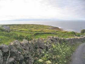
#MarineNotice - The latest Marine Notice from the Department of Transport, Tourism and Sport (DTTAS) advises that University College Dublin is running a scientific wave measurement campaign deploying a bed mounted ADCP at Inis Meáin in the Aran Islands s of yesterday (Saturday 28 January).
The ADCP, or acoustic Doppler current profiler, is deployed in a seabed-mounted frame at a depth of around 40 metres, with a ground line between the frame and a clump weight also rested on the seabed.
The purpose of the deployment is for measurement of waves and currents of the coast of Inis Meáin. This is a temporary deployment and it is proposed that the ADCP will be recovered before 15 May this year.
Co-ordinates and a map showing the deployment location are included in Marine Notice No 2 of 2017, a PDF of which is available to read or download HERE.
Piling & Pontoon Installation Works At Howth Trawler Dock
#MarineNotice - Marine Notice No 46 of 2016 advises that piling works were set to commence at Howth Fishery Harbour Centre, weather permitting, on or around this past Monday 21 November.
The works involve the installation of 3 No. circular steel piles and the subsequent installation of a floating pontoon at the trawler dock (Western Basin) at latitude 53°23'32” N and longitude 6°4’6” W.
The works are being advanced by a marine contractor working from a jack-up barge 18m x 18m in size, using heavy civil engineering plant and machinery, work vessels and platforms. Divers will be employed onsite to install anodes to the piles.
For safety reasons, mariners are requested to proceed slowly and with caution in the trawler dock and to give the works a wide berth. Wave wash from vessels should be avoided.
These works are expected to be ongoing until the end of December 2016, weather permitting.
Marine Notice: Annual Groundfish Survey Off South & West Coasts
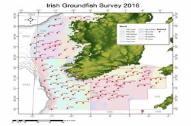
#MarineNotice - The Marine Institute advises that the annual Irish Groundfish Survey (IGFS2016) will be carried out off the South and West coasts of Ireland between Monday 14 November and Sunday 18 December in fulfilment of Ireland’s Common Fisheries Policy obligations.
The IGFS is a demersal trawl survey consisting of a minimum of 125 fishing hauls of 30 minutes duration each. Fishing in 2016 will take place within a 2nm radius of the positions indicated in Marine Notice 44 of 2016, available to read or download HERE.
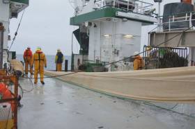
The survey will be conducted by the RV Celtic Explorer (Callsign EIGB), which will display all appropriate lights and signals during the survey and will also be listening on VHF Channel 16. The vessel will be towing a high headline GOV 36/47 demersal trawl during fishing operations.
The Marine Institute requests that commercial fishing and other marine operators keep a 2nm area around the tow points clear of any gear or apparatus during the survey period.
While there is no statutory provision for the loss of gear at sea, the Marine Institute will make every effort to avoid gear adequately marked according to legislation that may be encountered in the notified areas.
In the event that an operator has static gear or other obstructions within 2nm of the points listed above it is the responsibility of the owner to notify the survey managers or vessel directly. This should be communicated by identifying specifically which ‘Prime Station’ is of concern using the appendix and contact details provided in the Marine Notice. It is not required to provide positional details of commercial operations beyond 3-4nm of the survey points provided.
Specifics of any fishing gear or other obstructions that are known and cannot be kept clear of these survey haul locations can be notified using the contact details provided in the Marine Notice.
Annual Irish Groundfish Survey Now Under Way
#Fishing - The Marine Institute’s annual Irish Groundfish Survey (IGFS2016) began off the North West Coast on Sunday 25 September, continuing till Thursday 6 October, in fulfilment of Ireland’s Common Fisheries Policy obligations.
IGFS2016 is a demersal trawl survey consisting of a minimum of 45 fishing hauls each of 30 minutes’ duration. Fishing in 2016 is taking place within a two-nautical-mile radius of positions indicated in Marine Notice No 41 of 2016, available to read or download HERE.
The survey is being conducted by the RV Celtic Explorer (Callsign EIGB), which will display all appropriate lights and signals throughout and is also listening on VHF Channel 16.
The Celtic Explorer will be towing a high headline GOV 36/47 demersal trawl during fishing operations. The Marine Institute requests that commercial fishing and other marine operators keep a two-nautical-mile area around the tow points clear of any gear or apparatus during the survey period outlined above.
While there is no statutory provision for the loss of gear at sea, the Marine Institute will make every effort to avoid gear adequately marked according to legislation that may be encountered in the notified areas.
In the event that an operator has static gear or other obstructions within 2nmi of the haul points, it is the responsibility of the owner to notify the survey managers or vessel directly.
This should be communicated by identifying specifically which ‘Prime Station’ is of concern using the appendix and contact details provided.
It is not required to provide positional details of commercial operations beyond 3-4nmi of the survey points provided. Specifics of any fishing gear or other obstructions that are known and cannot be kept clear of these survey haul locations can be notified using the contact details provided in the Marine Notice.
Marine Notice: Seabed Mapping Off East Coast
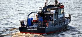
#MarineNotice - All vessels on the East Coast, particularly those engaged in fishing, are requested to give a wide berth to a survey vessel carrying out seabed mapping operations on behalf of Clinton Marine Survey AB.
M/V Northern Wind (Callsign 2IOX2) began its survey on Thursday 22 September for a 15-day period, weather permitting. The vessel is displaying appropriate lights and markers, and is listening on VHF Channel 16 throughout the project.
The vessel may also be towing equipment including a sonar scanner, prompting the call for all other boats to keep a sharp lookout in relevant areas, the co-ordinates for which are detailed in Marine Notice No 40 of 2016, available to read or download HERE.
Aran Islands Cable Repairs Under Way Weeks After Power Outage
#MarineNotice - Repair works are currently ongoing on the Inis Mór–Inis Meáin cable weeks after a fault left the Aran Islands without power for a number of days.
The works, which began last Saturday 10 September and will continue for another week, weather permitting, are being carried out from an offshore platform manoeuvred with the assistance of workboats, as detailed in Marine Notice No 39 of 2016.
The tug ABBE is also operational in the vicinity of the platform during the repairs. Both platform and tug vessel maintain a listening watch on VHF Channels 12 and 16 for the duration of the project.
The platform is displaying day shapes and night lights as required in accordance with the International Regulations for Prevention of Collisions at Sea (COLREGS).
All vessels, particularly those engaged in fishing, are requested to give the area a wide berth and keep a sharp lookout in the relevant areas.
Another recent Marine Notice advises of a programme of maintenance and inspection on the Corrib subsea facilities from this week for the next three week.
Marine Notice No 38 of 2016 says the work will all take place within the 500m Safety Zone and will involve carrying out a programme of maintenance to investigate and repair some of
the subsea facilities as required.
The support vessel Olympic Ares will carry out the maintenance and inspection using a remote operated vehicle or ROV. The vessel will be listening on VHF Channel 16 throughout the project.
Marine Notice: Site Investigation Works At Dingle Fishery Harbour Centre
#MarineNotice - Site investigation works are being carried out at Dingle/An Daingean Fishery Harbour Centre in Co Kerry, according to the latest Marine Notice from the Department of Transport, Tourism and Sport.
The works involve the drilling of multiple boreholes at locations, subject to minor variations, as indicated by the co-ordinates and map included in Marine Notice No 37 of 2016, a PDF of which is available to read or download HERE.
Drilling was expected to begin yesterday (Monday 5 September) and will finish on or around Friday 28 October, weather permitting.
A jack-up barge will be moved to the various borehole locations by the tug Samson (Callsign ZQVL6) and will remain on site overnight during the operations.
All appropriate lights will be displayed by the barge at night. Radio navigation warnings will be transmitted on VHF Channel 16 throughout the works.


 in Belfast Harbour to encourage more women to pursue a career in Port Operations.")
")

 Sarah Phelan (6 yrs) and Sophie Costello (8 yrs)")


 won the Round Ireland Race from Wicklow every which way as Tonnere de Breskens for the late great Piet Vroon in 2010, and with her return for 2024’s race as Searcher, she is immediately among the favourites")

 will be going head-to-head with long-lost multi-club-representing sister Two Farr at Howth’s three-day Wave Regatta, starting Friday")

